
Hiking Krafla Volcano: A Complete Guide to Iceland’s Active Caldera and Lava Fields
Explore the dynamic volcanic landscape of Krafla in Northeastern Iceland. This guide covers the geology, hiking terrain, routes, safety, permits, and accommodation options for trekking the active Krafla caldera, including the famous Viti Crater and Leirhnjúkur lava fields.
Quick Volcano Snapshot
| Attribute | Value |
|---|---|
| Volcano type | Caldera |
| Elevation | 818 meters (2,684 feet) |
| Location | Northeastern Iceland, near Lake Mývatn |
| Activity status | Active |
| Trekking difficulty | Moderate |
| Typical trek duration | 1 to 3 hours depending on route |
| Altitude gain | Minimal to moderate (up to 50 meters on some trails) |
| Terrain type | Lava fields, ash slopes, rocky paths, geothermal areas |
| Best season | June to September |
| Temperature range | 5°C to 15°C (41°F to 59°F) in summer |
| Permit requirement | No special permit required for hiking; guided tours recommended |
The Experience of Hiking Krafla Volcano
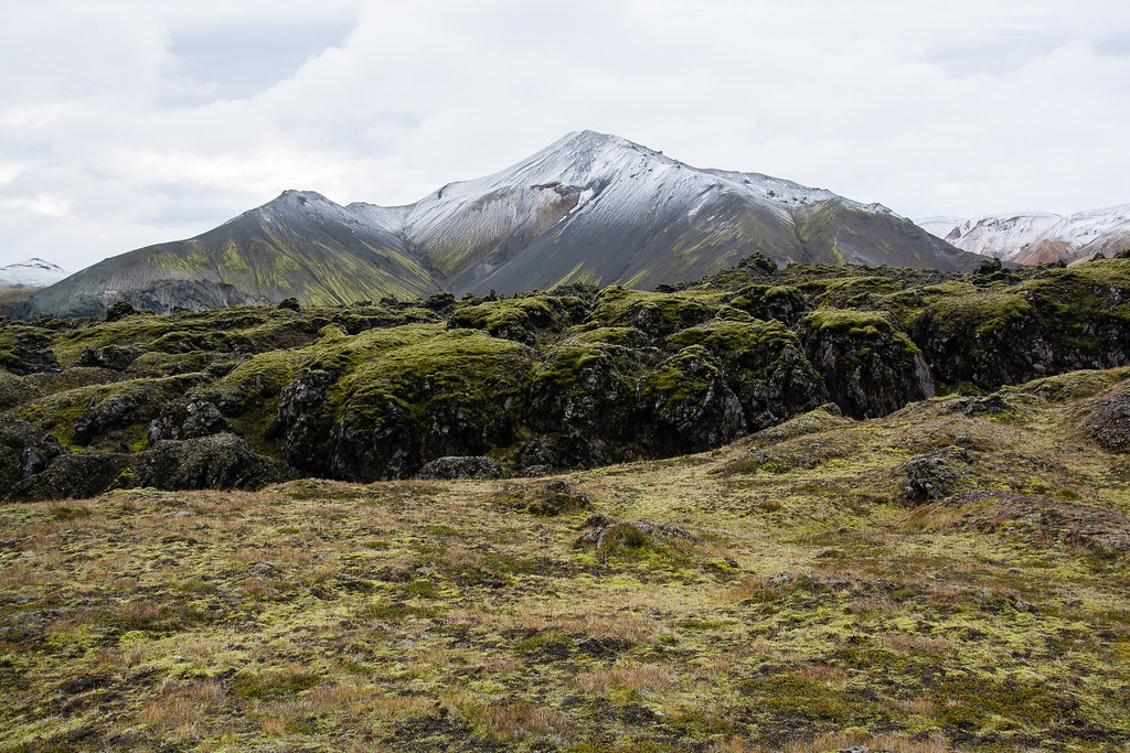
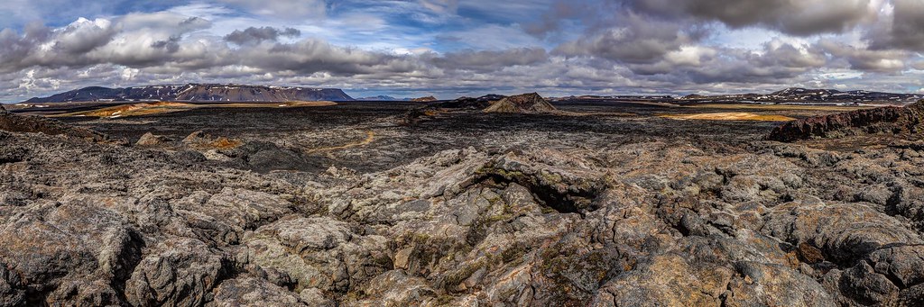
Approaching Krafla Volcano, hikers are immediately immersed in a landscape shaped by raw geological forces. The vast caldera stretches before you, dotted with steaming vents and jagged lava fields that tell stories of fiery eruptions. The contrast between the barren, black basalt terrain and the vivid blue-green waters of the Viti Crater lake creates a surreal atmosphere. Walking along the crater rim or across the Leirhnjúkur lava fields, you feel the pulse of the Earth beneath your feet. The scent of sulfur and the hiss of escaping steam deepen the connection to the planet’s inner power. Reaching the crater’s edge offers a profound sense of awe and accomplishment, standing on the rim of one of Iceland’s most active volcanic systems.
Geological Background of Krafla Volcano
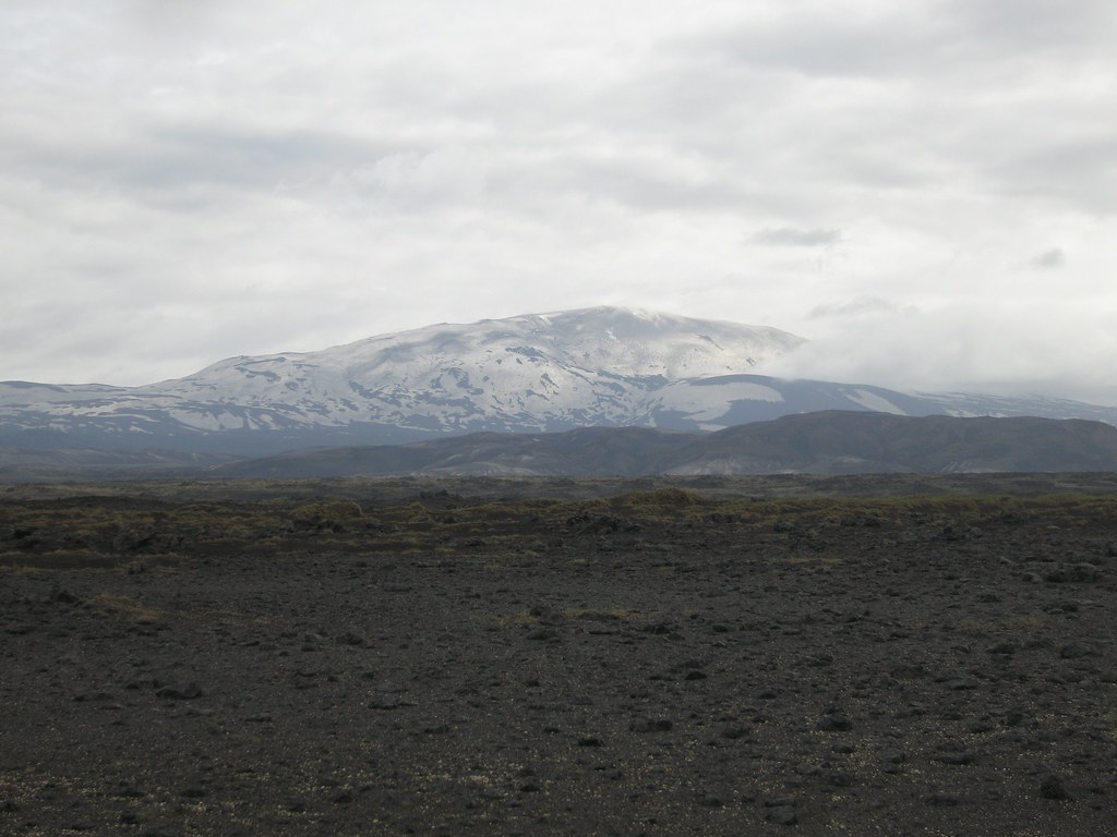
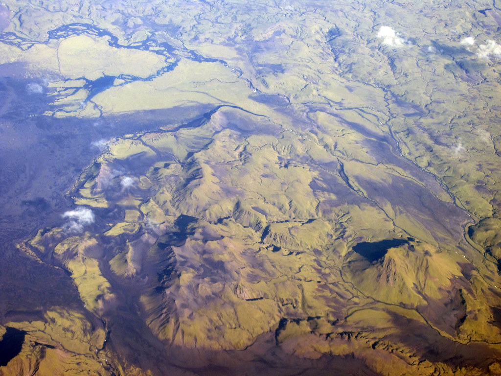
Krafla is a vast volcanic caldera located in Northeastern Iceland, formed during the last glacial period approximately 100,000 years ago. It is part of a larger volcanic system that extends about 90 kilometers along the Mid-Atlantic Ridge, where the North American and Eurasian tectonic plates diverge. This tectonic setting makes Krafla one of the most volcanically active regions in Iceland. The caldera itself spans roughly 10 kilometers in diameter and contains numerous craters, fissures, and geothermal features. Notably, Krafla has erupted 29 times since Iceland was settled, with two major eruptive episodes: the Mývatn Fires (1724–1729) and the Krafla Fires (1975–1984). These eruptions produced extensive lava flows and reshaped the landscape, creating the dark, rugged lava fields visible today. The Viti Crater, formed during an explosive eruption in 1724, contains a striking turquoise lake that contrasts sharply with the surrounding black lava. The area is also rich in fumaroles, mud pots, and sulfur deposits, providing a vivid display of ongoing geothermal activity.
Terrain and Hiking Experience at Krafla
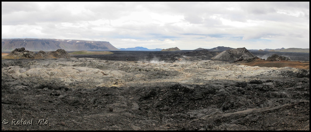
Hiking in the Krafla volcanic region offers a unique and varied terrain that challenges and delights trekkers. The primary trails wind through hardened lava fields, ash-covered slopes, and geothermal zones marked by steaming vents and bubbling mud pots. The lava fields, formed during the Krafla Fires between 1975 and 1984, consist of jagged basalt rocks and uneven surfaces that require sturdy footwear and careful footing. Some sections involve scrambling over rough lava formations, while others traverse smoother, moss-covered paths that provide a softer walking experience. The Leirhnjúkur area is particularly notable for its active geothermal features, where steam rises continuously from cracks in the earth, and the ground feels warm beneath your feet. The trail around the Viti Crater is shorter and less demanding, with a well-maintained path leading to viewpoints overlooking the vivid blue crater lake. However, access around the full crater rim is restricted for safety reasons, limiting hikers to about one-third of the perimeter. Weather conditions can vary rapidly, with strong winds and sudden temperature drops common near the summit and exposed ridges. Altitude is modest, but the volcanic terrain’s unevenness and loose scree can increase hiking difficulty. Overall, the hike combines moderate physical exertion with extraordinary geological scenery, making it accessible to hikers with reasonable fitness and experience. The surreal landscape, punctuated by geothermal activity and stark contrasts between black lava and vibrant mineral deposits, creates an otherworldly hiking experience unlike any other.
What Makes the Krafla Volcano Trek Unique
Krafla’s volcanic landscape is distinguished by its recent and ongoing geological activity, which shapes a terrain that feels both ancient and alive. The presence of the Viti Crater, with its striking turquoise lake formed by explosive eruptions, offers a rare and vivid focal point for hikers. The surrounding lava fields, still warm decades after the last eruptions, provide a tactile connection to the Earth’s molten interior. The Leirhnjúkur geothermal area, with its steaming vents and bubbling mud pots, showcases the dynamic forces beneath the surface. Unlike many dormant volcanoes, Krafla’s frequent eruptions and geothermal phenomena create a constantly evolving environment. The proximity to Lake Mývatn and other volcanic features in the region allows trekkers to combine multiple geological wonders in one trip. Additionally, the integration of the Krafla Geothermal Power Station highlights the human use of volcanic energy, blending natural power with sustainable technology. This combination of active volcanism, unique crater lakes, and geothermal landscapes makes Krafla a singular destination for volcano enthusiasts and adventurous hikers.
The Summit and Crater Experience at Krafla
Reaching the rim of the Viti Crater is a highlight of any Krafla trek. The crater’s steep walls descend to a vivid blue-green lake, whose color contrasts dramatically with the surrounding black lava and red volcanic soil. The air here is tinged with the sharp scent of sulfur, and the ground occasionally emits warm steam from fumaroles hidden among the rocks. Standing at the highest accessible point along the crater rim, hikers are rewarded with panoramic views of the vast caldera, the sprawling lava fields, and the distant peaks of the Icelandic Highlands. The soundscape is dominated by the gentle hiss of escaping gases and the occasional rumble from deeper within the volcanic system. The crater’s raw beauty and the palpable presence of geothermal energy create a sensory experience that is both humbling and exhilarating. Visitors are reminded of the immense power that forged this landscape and the ongoing forces that continue to shape it.

Best Time to Trek Krafla Volcano
The optimal time to hike Krafla is during the Icelandic summer months, from June through September. During this period, temperatures are milder, ranging from 5°C to 15°C (41°F to 59°F), and daylight hours are extended, allowing for flexible trekking schedules. The trails are generally free of snow, and weather conditions are more stable, although sudden changes can still occur. Winter and shoulder seasons bring harsher weather, including snow cover, icy paths, and limited daylight, which increase the difficulty and risk of hiking. Additionally, some areas may be inaccessible or closed due to volcanic monitoring or safety concerns during periods of increased activity. Early morning or late evening hikes can offer spectacular lighting for photography, especially around the crater rim. Visitors should always check current volcanic activity reports and weather forecasts before planning their trek to ensure safe conditions.
Routes and Trail Options for Krafla Volcano
The primary hiking route in the Krafla area is the loop trail through the Leirhnjúkur lava fields and geothermal area, starting from the designated parking area near the Krafla power station. This trail covers approximately 3.5 kilometers and typically takes 1 to 1.5 hours to complete. It offers a comprehensive experience of the volcanic terrain, passing steaming vents, mud pots, and fresh lava flows. The path is well-marked and suitable for hikers with basic fitness, though sturdy footwear is essential due to uneven and rocky surfaces. Another popular option is the short trail to the Viti Crater, which begins at a nearby parking lot. This easy walk leads to viewpoints along about one-third of the crater rim, providing stunning views of the turquoise crater lake. Full circumnavigation of the crater is currently restricted for safety reasons. For more adventurous hikers, combining these trails with nearby volcanic sites around Lake Mývatn, such as Hverfjall crater or Dimmuborgir lava formations, creates a longer and more varied trekking itinerary. Guided tours often include transportation and expert commentary, enhancing the experience and ensuring safe navigation of the geothermal landscape.

Difficulty Assessment of Krafla Volcano Trek
The Krafla trek is classified as a moderate volcano hike. The terrain includes uneven lava fields, rocky paths, and some loose scree, requiring good balance and sturdy hiking boots. Elevation gain is minimal, with the highest points rising only about 50 meters above the surrounding landscape, so altitude sickness is not a concern. The main challenges stem from the rugged volcanic terrain and exposure to variable weather conditions, including strong winds and sudden temperature changes. The trails are generally well-marked and do not require technical climbing skills or specialized equipment. Hikers should possess a reasonable level of fitness to comfortably navigate the uneven ground and maintain stability on loose volcanic rock. Overall, the trek is accessible to most hikers with some experience on rough terrain and a preparedness for Iceland’s unpredictable weather.
Essential Gear for Hiking Krafla Volcano
Proper gear is crucial for a safe and enjoyable hike at Krafla. Recommended items include sturdy hiking boots with strong grip to handle jagged lava and loose scree. Trekking poles can provide additional stability on uneven terrain. A windproof and waterproof jacket is essential due to Iceland’s variable weather and strong winds. Layered clothing helps manage temperature fluctuations. Sun protection, including sunglasses and sunscreen, is important as the volcanic landscape offers little shade. A headlamp is useful for early morning or late evening hikes during extended daylight hours. Carry sufficient water and snacks, as there are no facilities along the trails. A gas mask or respirator is generally not required but may be considered by sensitive individuals due to occasional sulfur fumes near fumaroles. A map or GPS device and a fully charged mobile phone enhance safety. Finally, a camera is recommended to capture the extraordinary volcanic scenery.
Safety and Volcanic Hazards at Krafla
While hiking Krafla offers spectacular views, it also requires awareness of volcanic hazards. The area is geothermally active, with fumaroles emitting sulfurous gases that can irritate the respiratory system, especially for sensitive individuals. Staying on marked trails is critical to avoid unstable ground and fragile crusts that may collapse. Crater edges can be steep and unstable, so caution is necessary near rims, especially where access is restricted. Loose volcanic rock and scree increase the risk of slips and falls. Although Krafla is actively monitored by Icelandic volcanic agencies, sudden eruptions or increased geothermal activity can occur. Visitors should check current volcanic activity reports and heed any warnings or trail closures. Weather can change rapidly, bringing strong winds, rain, or fog, which reduce visibility and trail safety. Carrying appropriate gear and informing others of your plans enhances safety. Guided tours provide expert knowledge and reduce risks associated with the volcanic environment.
Permits, Guides, and Logistics for Visiting Krafla Volcano
No special permits are required to hike the Krafla volcanic area, making it accessible for independent travelers. However, guided tours are widely available and recommended for those seeking expert insights and enhanced safety. Notable tour operators include Iceland Volcano Tours, Arctic Adventures, and Zephyr Adventures, all offering day trips and multi-day hiking packages that cover Krafla and surrounding volcanic sites. These tours often include transportation from Reykjavik or Akureyri, guiding services, and safety briefings. The Krafla area is accessible by car via Route 863 from Lake Mývatn, approximately a 15-minute drive from the Ring Road. Renting a car in Akureyri or Reykjavik is the most convenient way to reach the site independently. The Krafla Geothermal Power Station is open to visitors during summer months and provides educational exhibits on geothermal energy. Parking is available near the Viti Crater and Leirhnjúkur trailheads. Visitors should plan for variable weather and bring appropriate gear. While no entry fees apply, some guided tours charge between €50 and €150 depending on duration and inclusions. Booking in advance is advised during peak summer months. Public transportation options are limited, so self-drive or guided tours are preferred. Overall, logistics are straightforward, with well-maintained roads and clear signage facilitating access to this active volcanic region.
Where to Stay Near Krafla Volcano
The best base for exploring Krafla Volcano is the Lake Mývatn area, located about 10 kilometers southwest of the caldera. Reykjahlíð, the main village on the lake’s shore, offers a range of accommodations including guesthouses, hotels, and hostels. Popular options include the Fosshotel Mývatn, known for its modern amenities and proximity to natural attractions, and the Vogafjós Guesthouse, which combines cozy lodging with a farm-to-table restaurant experience. For budget travelers, the HI Mývatn Hostel provides affordable dormitory and private rooms. Many accommodations offer easy access to the Ring Road and Route 863 leading to Krafla, with driving times of approximately 15 minutes. Amenities in the area include restaurants, grocery stores, and geothermal spas such as the Mývatn Nature Baths, ideal for relaxing after a day of hiking. For those seeking a more remote experience, several eco-camps and cabins are available around the lake, offering tranquility and direct access to hiking trails. Akureyri, Iceland’s second-largest city, is about 100 kilometers west of Krafla and provides additional lodging, dining, and transport options. Staying in these nearby bases allows visitors to combine Krafla hikes with exploration of other volcanic and geothermal sites in the region.