

Mount Ngauruhoe Summit via Tongariro Northern Circuit: Ultimate Volcano Trekking Guide in New Zealand
Explore the demanding and iconic Mount Ngauruhoe summit trek via the Tongariro Northern Circuit in New Zealand’s Central North Island. This multi-day volcanic hike offers dramatic landscapes, volcanic craters, emerald lakes, and a close encounter with one of the most active stratovolcanoes in the region.
Quick Volcano Snapshot
| Attribute | Value |
|---|---|
| Volcano type | Stratovolcano |
| Elevation | 2,291 m (7,516 ft) |
| Location | Central North Island, New Zealand |
| Activity status | Active |
| Trekking difficulty | Demanding |
| Typical trek duration | 3-4 days |
| Altitude gain | Approx. 1,100 m |
| Terrain type | Lava fields, ash slopes, scree, volcanic rock |
| Best season | Late October to April |
| Temperature range | 5°C to 20°C (varies with altitude and season) |
| Permit requirement | Booking required for huts and campsites during Great Walks season |
The Experience of Hiking Mount Ngauruhoe via Tongariro Northern Circuit
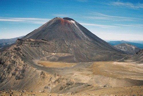
Approaching Mount Ngauruhoe through the Tongariro Northern Circuit immerses you in a raw volcanic landscape sculpted by fire and time. The trek winds through barren lava flows, steaming vents, and vividly colored crater lakes, contrasting sharply with the lush forests and alpine meadows nearby. The imposing, perfectly conical summit of Ngauruhoe dominates the skyline, evoking a sense of awe and respect. As you ascend, the terrain shifts from rugged volcanic rock to loose scree slopes, challenging your footing and endurance. Reaching the summit offers a profound connection with the Earth’s fiery heart, rewarding trekkers with panoramic views of the Central North Island and a visceral sense of the volcano’s power.
Geological Background of Mount Ngauruhoe
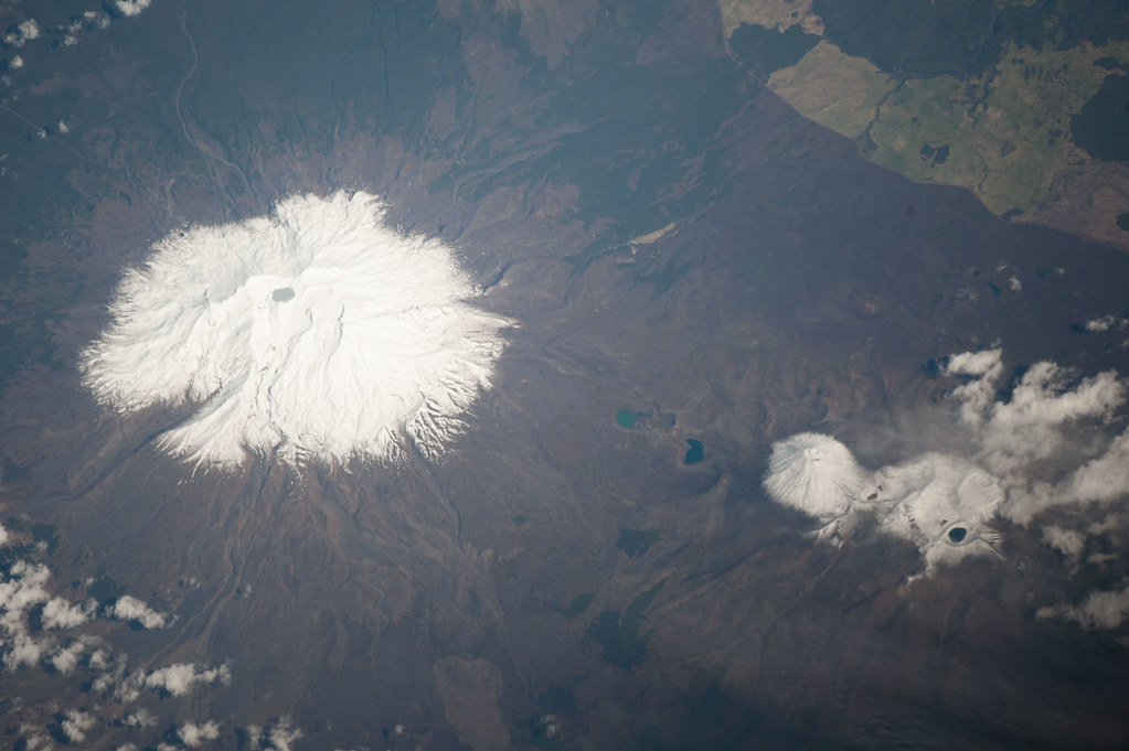
Mount Ngauruhoe is a classic stratovolcano formed by successive layers of lava, ash, and volcanic debris. It is part of the Tongariro volcanic complex within Tongariro National Park, a UNESCO World Heritage site. The volcano emerged as a parasitic cone on the flank of Mount Tongariro and is one of New Zealand’s most active volcanoes, with its last eruption recorded in 1977. The region’s volcanic activity is driven by the subduction of the Pacific Plate beneath the Indo-Australian Plate, part of the Pacific Ring of Fire. The landscape features explosion craters, lava flows, and fumaroles emitting steam and sulfurous gases. The mineral-rich volcanic soils and thermal activity create unique ecological niches and strikingly colored lakes such as the Emerald Lakes, formed in explosion pits. This dynamic geology offers trekkers a vivid lesson in volcanic processes and landscape evolution.
Terrain and Hiking Experience on the Tongariro Northern Circuit
The Tongariro Northern Circuit is a demanding multi-day trek covering approximately 43 kilometers, encircling Mount Ngauruhoe and traversing diverse volcanic terrain. The hike begins near Whakapapa Village, progressing through a landscape marked by ancient lava flows, rugged volcanic rock, and steaming vents. The initial sections feature stream beds and forested areas, but soon the trail ascends into alpine zones with sparse vegetation and exposed volcanic features.
Hikers encounter steep climbs, notably the ascent to the Mangatepōpō Saddle, which rewards with expansive views of the Central Plateau and distant peaks like Mount Taranaki. The trail then crosses the South Crater, a large volcanic basin, before climbing to the Red Crater, the highest point on the circuit at 1,868 meters. This section involves navigating loose scree fields and volcanic ash slopes, requiring careful footing and stamina.
The terrain is varied: from solidified lava flows to soft pumice and ash, with some scrambling over jagged volcanic rocks. Weather conditions can change rapidly, with strong winds and temperature fluctuations common at higher elevations. Descents can be tough on knees, especially on scree slopes, demanding trekking poles for stability.
Along the route, hikers pass the vividly colored Emerald Lakes, whose turquoise and green hues result from volcanic minerals. The trail then descends through the Oturere Valley, weaving among jagged lava formations and into beech forest before reaching the Waihohonu Hut.
The final day includes a gradual climb to Tama Saddle, with an optional side trip to the Tama Lakes, two old explosion craters offering serene alpine views. The trail then descends back to Whakapapa Village.
Overall, the trek combines strenuous ascents and descents with spectacular volcanic landscapes, requiring good fitness, proper gear, and readiness for alpine conditions. The trail is well-marked but can be eroded and rough in places, especially near the trailhead. The experience is both physically challenging and visually rewarding, offering intimate encounters with New Zealand’s volcanic heart.

What Makes the Mount Ngauruhoe Trek Unique
Mount Ngauruhoe’s trek stands out for its dramatic volcanic landscapes and cultural significance. The volcano’s near-perfect conical shape, famously featured as Mount Doom in the Lord of the Rings films, provides an iconic silhouette against the sky. The trek offers a rare opportunity to explore active volcanic terrain, including steaming fumaroles, explosion craters, and vibrant mineral-rich lakes.
The Tongariro Northern Circuit is one of New Zealand’s Great Walks, combining natural beauty with geological wonder. The diversity of terrain—from barren lava deserts to lush alpine meadows—creates a dynamic hiking experience. The cultural reverence of the local Māori iwi, Ngāti Tūwharetoa, adds a profound spiritual dimension, as the peaks are considered sacred. This respect influences access and conservation efforts, enhancing the trek’s authenticity.
The circuit’s multi-day format allows hikers to experience sunrise and sunset over the volcanic landscape, moments of solitude rare on popular day hikes. The panoramic views from the Red Crater and summit areas reveal the vastness of the Central Plateau and surrounding ranges, making this trek a unique blend of adventure, geology, and cultural heritage.
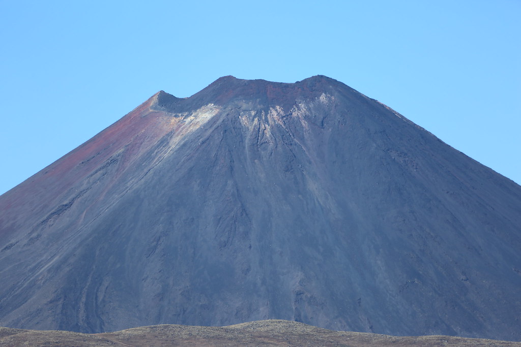
The Summit and Crater Experience on Mount Ngauruhoe
Reaching the summit of Mount Ngauruhoe is a thrilling climax to the trek. The final ascent involves a steep scramble up loose scree and volcanic rock, demanding concentration and physical effort. At the summit, hikers are rewarded with breathtaking 360-degree views encompassing the Central North Island’s volcanic plateau, including Mount Tongariro, Mount Ruapehu, and on clear days, distant peaks like Mount Taranaki.
The crater itself is a stark, rugged bowl marked by hardened lava and volcanic debris. The air carries a faint sulfuric tang from fumaroles and steam vents, a reminder of the volcano’s active nature. The ground may feel warm in places, and the sound of escaping gases adds to the sensory experience. The summit’s exposed position means wind can be strong and temperatures cooler, so hikers often pause briefly to absorb the dramatic landscape before descending.
This moment atop Mount Ngauruhoe connects trekkers to the primal forces shaping the Earth, offering a profound sense of achievement and awe.
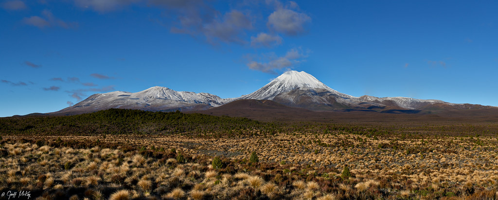
Best Time to Trek Mount Ngauruhoe via Tongariro Northern Circuit
The optimal trekking season for the Tongariro Northern Circuit and Mount Ngauruhoe summit is from late October through April, coinciding with New Zealand’s spring to autumn months. During this period, weather conditions are generally more stable, with longer daylight hours and reduced snow and ice hazards.
Outside this Great Walks season, from May to late October, the trail can be cold, wet, and snow-covered, requiring advanced alpine skills, equipment, and experience. The huts operate on a first-come, first-served basis with limited facilities, and weather conditions can be severe, including avalanches and short daylight.
Volcanic activity is monitored continuously, and access may be restricted during periods of increased activity for safety. Early morning starts are recommended to avoid afternoon weather changes and to experience the sunrise over the volcanic landscape.
Hikers should check current conditions and volcanic alerts before embarking and plan accordingly for seasonal hazards such as strong winds, sudden temperature drops, and potential volcanic gas emissions.
Routes and Trail Options for Mount Ngauruhoe Trekking
The primary route to summit Mount Ngauruhoe is via the Tongariro Northern Circuit, a 43.1 km loop that typically takes 3 to 4 days to complete. The circuit starts and ends at Whakapapa Village, with three main huts along the way: Mangatepōpō, Oturere, and Waihohonu.
Day 1 covers Whakapapa Village to Mangatepōpō Hut (8.5 km), featuring volcanic views and ancient lava flows. Day 2 is the most challenging, from Mangatepōpō Hut to Oturere Hut (12.8 km), including the steep climb to the Mangatepōpō Saddle, crossing South Crater, ascending Red Crater, and passing the Emerald Lakes. The summit of Mount Ngauruhoe is accessible via a marked but steep and loose scree path from the Red Crater area.
Day 3 leads from Oturere Hut to Waihohonu Hut (7.5 km), descending through valleys and beech forest. Day 4 returns to Whakapapa Village (14.3 km), including a climb to Tama Saddle and an optional side trip to the Tama Lakes.
For those seeking a shorter option, the Tongariro Alpine Crossing is a popular one-day hike covering 19.4 km, including the volcanic highlights but excluding the full circuit. Guided tours and shuttle services operate to facilitate logistics.
The circuit can be walked in either direction, with most hikers choosing to go clockwise to tackle the steepest climbs earlier. Very fit individuals may complete the circuit in 2 days, but each day involves at least 8 hours of hiking. The trail is well-marked but includes rough and eroded sections, requiring good navigation and fitness.
Difficulty Assessment of Mount Ngauruhoe Trek
The Mount Ngauruhoe summit trek via the Tongariro Northern Circuit is classified as a demanding volcano ascent. The terrain includes steep ascents and descents, loose scree slopes, volcanic ash, and rugged lava fields, requiring good balance and endurance. Altitude is moderate, with the summit at 2,291 meters, which can cause mild altitude effects in some hikers.
The trail demands a solid fitness level due to daily distances of 8 to 14 kilometers with significant elevation gain and loss. Technical climbing skills are not required, but the scree sections and exposed ridges necessitate caution and sure-footedness. Weather conditions can add to the challenge, with potential for strong winds, rapid temperature changes, and sudden storms.
This trek is not suitable for beginners or those with limited hiking experience. Preparation, proper gear, and physical conditioning are essential for a safe and enjoyable experience.
Essential Gear for Trekking Mount Ngauruhoe
Trekking Mount Ngauruhoe requires specialized gear to handle volcanic terrain and alpine conditions. Essential items include sturdy hiking boots with excellent grip for scree and rocky surfaces, trekking poles to aid balance and reduce knee strain on descents, and gaiters to protect against volcanic ash and debris.
A windproof and waterproof jacket is crucial due to unpredictable weather and strong winds at higher elevations. Layered clothing allows adjustment for temperature fluctuations. A headlamp is recommended for early starts or late finishes.
Given the presence of volcanic gases, carrying a lightweight respirator or gas mask can be prudent, especially near fumaroles. Sun protection, including a wide-brimmed hat, sunglasses, and high-SPF sunscreen, is necessary as the trail offers little shade.
Hydration systems and sufficient water are vital, as water sources are limited. A map, compass, or GPS device is advised despite the well-marked trail. Finally, pack a first aid kit, emergency shelter, and sufficient food for multi-day trekking.
Safety and Volcanic Hazards on Mount Ngauruhoe
Mount Ngauruhoe is an active volcano, presenting specific hazards that hikers must respect. Volcanic gases such as sulfur dioxide can be harmful, especially near fumaroles and steam vents. It is important to avoid lingering in these areas and heed any warnings or closures issued by monitoring agencies.
The terrain includes unstable crater edges, loose scree, and falling rocks, requiring careful footing and attention. Sudden weather changes can bring cold temperatures, strong winds, and reduced visibility, increasing risk.
Eruptions, while infrequent, can occur with little warning. The New Zealand Department of Conservation and GeoNet continuously monitor volcanic activity and provide alerts. Hikers should check current volcanic activity reports before and during their trek.
Emergency shelters and huts are available along the circuit, but communication can be limited. Carrying a personal locator beacon or satellite communication device is recommended for remote areas. Respecting cultural restrictions, such as avoiding summit ascents when advised, also contributes to safety and preservation.
Permits, Guides, and Logistics for Mount Ngauruhoe Trekking
The Tongariro Northern Circuit, including the Mount Ngauruhoe summit route, is managed as one of New Zealand’s Great Walks. During the Great Walks season (late October to April), hikers must book accommodation in the Department of Conservation (DOC) huts or campsites in advance. Huts provide bunks with mattresses, heating, toilets, gas cooking facilities, solar lighting, and cold running water. Campsites are located near huts for those preferring to camp.
Booking is essential as huts fill quickly during peak season. Outside the Great Walks season, huts operate on a first-come, first-served basis with limited facilities and no resident rangers.
Several reputable tour operators offer guided multi-day hikes on the Tongariro Northern Circuit, providing expert guidance, logistics support, and shuttle services. Notable operators include New Zealand Walks, Walking Legends, Unforgettable NZ Tours, and Entranced by Wilderness. These companies handle permits, accommodation bookings, transport, and provide knowledgeable guides familiar with volcanic terrain and local culture.
Trailheads are accessible from Whakapapa Village, which offers parking and visitor facilities. Shuttle services operate from nearby towns such as Turangi and Taupo, facilitating access and return. During peak season, parking at trailheads can be limited, making shuttle use advisable.
Permits and hut bookings can be made through the DOC website or authorized agents. Fees for huts are approximately NZD 56 per person per night, and campsites around NZD 24 per person per night during the Great Walks season. Outside season, fees are reduced.
Hikers should prepare for self-sufficiency, carrying food, water, and appropriate gear. Weather and volcanic activity updates should be monitored regularly. Respect for cultural sensitivities is paramount; climbing the summits of Mount Ngauruhoe and Mount Tongariro is discouraged by the local Māori iwi, Ngāti Tūwharetoa, due to their sacred status.
Planning well in advance, utilizing experienced guides if unfamiliar with alpine volcanic trekking, and adhering to safety protocols ensures a rewarding and safe adventure.
Where to Stay Near Mount Ngauruhoe and Tongariro Northern Circuit
Accommodation options near Mount Ngauruhoe and the Tongariro Northern Circuit cater to a range of preferences, from backcountry huts to comfortable lodges and holiday homes.
The Department of Conservation manages three main huts along the circuit: Mangatepōpō Hut, Oturere Hut, and Waihohonu Hut. These huts provide basic but comfortable shelter with bunk beds, heating, toilets, gas cooking facilities, and solar lighting. They are strategically located for multi-day trekking and require advance booking during the Great Walks season.
For those preferring to stay off the trail, Whakapapa Village serves as the primary gateway with several accommodation options. Tongariro Lodge offers comfortable rooms with easy access to the trailhead. Nearby National Park Village provides additional lodges, motels, and holiday parks.
In the nearby town of Turangi, approximately 30 minutes’ drive from Whakapapa, a variety of accommodations are available, including Riverstone Lodge, Turangi Bridge Motel, and boutique bed and breakfasts like Olive Rabbit. These establishments offer amenities such as Wi-Fi, parking, and proximity to local shops and restaurants.
Camping is permitted only at designated campsites near the huts, with no camping allowed within 500 meters of the track. These campsites provide basic facilities and are popular among backpackers.
Shuttle services operate from Taupo and Turangi, facilitating access to trailheads and accommodations. Booking accommodation and transport well in advance is recommended, especially during peak hiking season.
Overall, the region offers a blend of rustic and comfortable lodging options, enabling trekkers to tailor their experience according to their preferences and budget.

![Mount Iwate volcano trek - Mt. Iwate / 岩手山(いわてさん)[9120 x 3380 = 30.9MP]](https://volcanohiking.com/wp-content/uploads/2026/03/01-mt-iwate-9120-x-3380-30-9mp.jpg)