
Mount Komagatake Volcano Trekking Guide: Exploring Hokkaido’s Active Stratovolcano
Mount Komagatake in Hokkaido, Japan, is an active stratovolcano offering a moderate trekking experience with panoramic views over Lake Onuma and surrounding landscapes. This guide covers the volcano’s geology, hiking terrain, routes, safety, permits, accommodations, and more for adventurous volcano trekkers.
Quick Volcano Snapshot
| Attribute | Value |
|---|---|
| Volcano type | Stratovolcano |
| Elevation | 1,131 meters |
| Location | Hokkaido, Japan |
| Activity status | Active (Dormant with occasional minor eruptions) |
| Trekking difficulty | Moderate |
| Typical trek duration | 1 to 4 hours depending on route |
| Altitude gain | Approximately 600 meters from base trailheads |
| Terrain type | Volcanic gravel, rocky slopes, forested trails |
| Best season | June to October |
| Temperature range | 5°C to 20°C during trekking season |
| Permit requirement | Notification required for climbs above 6th station |
Introduction: The Experience of Hiking Mount Komagatake
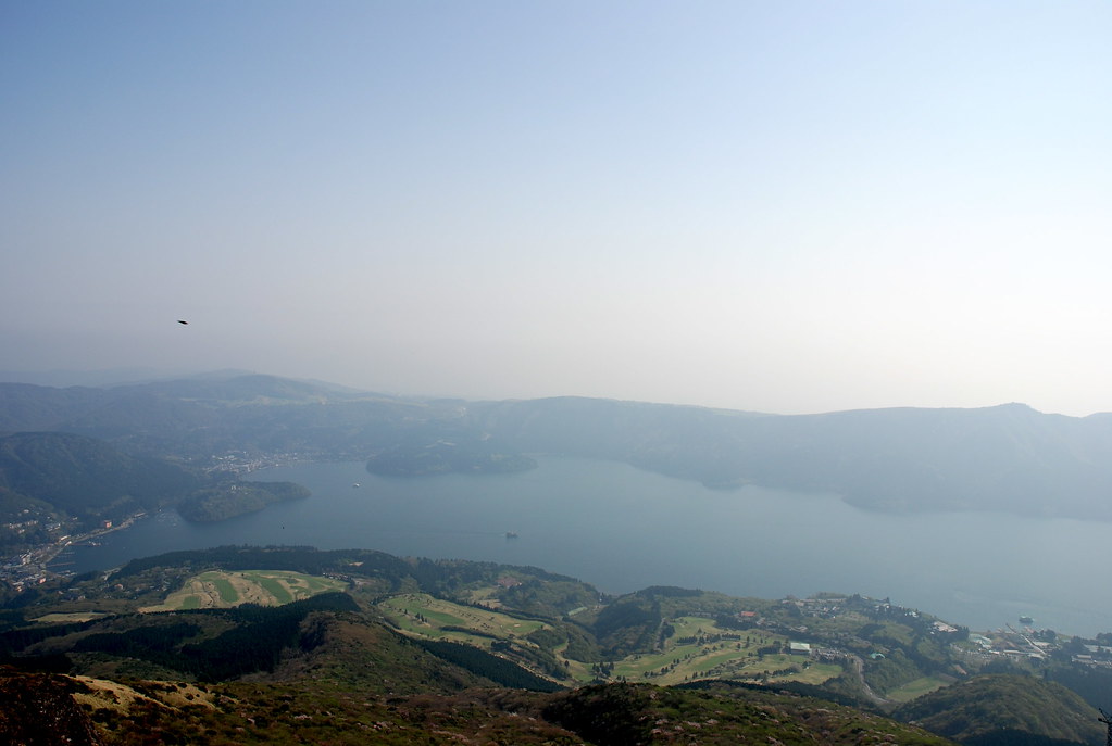
Approaching Mount Komagatake, hikers are greeted by the striking silhouette of a stratovolcano shaped by centuries of volcanic activity. The landscape transitions from dense forests to open volcanic gravel slopes, revealing the raw power of the earth beneath. As you ascend, the air cools and the scent of pine mingles with faint sulfurous hints near fumaroles. The panoramic views from the summit reward every step, with Lake Onuma’s shimmering surface reflecting the sky and the rugged ridges of the volcano’s peaks framing the horizon. The emotional impact of standing atop an active volcano, feeling the earth’s breath and witnessing the vastness of Hokkaido’s wilderness, is profound and unforgettable.

Geological Background of Mount Komagatake
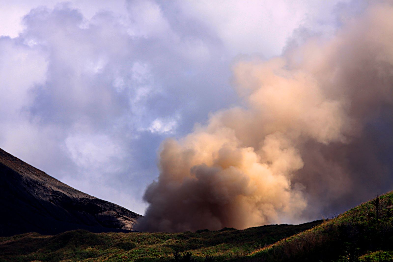
Mount Komagatake is a stratovolcano located in southern Hokkaido, Japan, rising to 1,131 meters. Its formation began approximately 27,000 years ago through repeated explosive eruptions that built up layers of lava and ash. The volcano’s summit once resembled a classic cone similar to Mount Fuji, but a major eruption in 1640 caused the summit area to collapse, creating a horseshoe-shaped crater approximately 2 kilometers in diameter. This collapse reshaped the mountain into a series of precipitous peaks such as Kengamine and Sawaradake, interspersed with gentler slopes. The crater floor still exhibits fumarolic activity, with steam vents and sulfur deposits indicating ongoing subterranean heat. The volcanic rocks around the summit include fragments of lava domes, and the area’s geology is marked by multiple lava flows and pyroclastic deposits. Mount Komagatake’s dynamic geological history is visible in its rugged terrain and changing landscape, offering hikers a direct connection to volcanic processes.
The Volcano Trek: Terrain and Hiking Experience
Hiking Mount Komagatake presents a varied terrain that challenges and delights trekkers. The ascent typically begins at the 6th station, where forested trails wind through dense larch and pine woods. Early sections offer shaded paths with soft soil and occasional roots, providing a gentle introduction. As the trail climbs higher, the forest thins and volcanic gravel and rocky scree dominate the landscape. Hikers encounter steep slopes composed of loose volcanic gravel that can shift underfoot, requiring careful footing and sometimes the use of trekking poles for stability. Near the summit, exposed volcanic rock faces and sharp ridges demand cautious navigation, especially in windy conditions. The trail’s moderate difficulty is compounded by occasional slippery patches from volcanic ash and gravel, and sudden weather changes can bring cold winds and reduced visibility. Despite these challenges, the trail rewards trekkers with expansive views of Lake Onuma, the Tsugaru Strait, and distant mountain ranges. The combination of forested paths, volcanic scree slopes, and rocky summit ridges creates a diverse hiking experience that immerses visitors in the volcano’s geological story. Altitude effects are mild due to the mountain’s moderate elevation, but hikers should be prepared for temperature shifts and wind exposure near the peak. Overall, the trek balances accessibility with authentic volcanic terrain, making it suitable for hikers with moderate fitness and some mountain experience.
What Makes the Mount Komagatake Trek Unique
Mount Komagatake stands out for its dramatic horn-like peaks formed by explosive eruptions and the horseshoe-shaped crater that reveals the volcano’s violent past. The trek offers unparalleled panoramic views over Lake Onuma, a serene volcanic lake whose surface mirrors the mountain’s changing moods through the seasons. The mountain’s ridgeline appears as if carved away, providing a distinctive silhouette visible from afar. The combination of active fumaroles near the summit and the surrounding lush forests creates a rare juxtaposition of volcanic power and natural beauty. Additionally, the cultural significance of Mount Komagatake as a sacred mountain with historic shrines adds a spiritual dimension to the trek. Seasonal changes transform the landscape dramatically, from vibrant autumn foliage to snow-dusted winter peaks, offering unique experiences year-round. This blend of geological intrigue, scenic vistas, and cultural heritage makes Mount Komagatake a compelling destination for volcano enthusiasts.
The Summit and Crater Experience
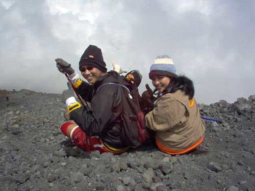
Reaching the summit of Mount Komagatake is a moment of awe and connection with the earth’s inner forces. The crater rim offers sweeping views of the surrounding volcanic peaks, the expansive Lake Onuma below, and on clear days, the distant cityscapes and the Tsugaru Strait. The air near the summit carries a faint sulfurous aroma from fumaroles venting steam and gases, a tangible reminder of the volcano’s active nature. The rocky terrain underfoot is warm in places, and the sound of escaping gases adds an eerie soundtrack to the experience. The summit shrine, Motomiya, invites reflection and respect for the mountain’s spiritual significance. The panoramic vistas and the sensory impressions of heat, smell, and sound combine to create a profound summit experience that resonates with both the adventurer and the contemplative traveler.
Best Time to Trek Mount Komagatake
The optimal trekking season for Mount Komagatake runs from June through October, when trails are free of snow and weather conditions are most stable. Summer months offer mild temperatures ranging from 10°C to 20°C, with lush greenery and blooming alpine plants. Autumn brings crisp air and vibrant foliage, enhancing the scenic beauty. Winter and early spring are generally inaccessible due to heavy snow and increased volcanic hazards. Hikers should be aware of occasional volcanic activity advisories and check local updates before planning their trip. Early morning climbs are recommended to avoid afternoon winds and to enjoy clearer views. Seasonal rains can make trails slippery, so proper gear is essential. Overall, late spring to early autumn provides the safest and most rewarding trekking conditions.
Trekking Routes and Trail Options
Mount Komagatake offers several trekking routes catering to different experience levels. The most popular trail starts at the 6th station parking area, ascending through forested paths to the summit in approximately 60 minutes. This route is well-marked and suitable for beginners with moderate fitness. For more adventurous hikers, longer routes begin from trailheads at Choshiguchi, Shikabe, and Sunahara, offering 3 to 4-hour ascents with varied terrain including scree slopes and rocky ridges. The trail from Choshiguchi passes along the lakeshore of Onuma before climbing steeply to the crater rim, providing diverse landscapes. Some routes merge near the upper slopes, leading to the prominent Kengamine peak, which requires rock scrambling and is recommended for experienced climbers. Descents can be made via the Komagatake Ropeway on the Hakone side, offering a scenic alternative to hiking down. Guided tours are available through local operators such as Hokkaido Adventure Tours and Go North Japan, providing logistical support and expert knowledge. Seasonal trail closures may apply due to volcanic activity or weather conditions, so checking current trail status is advised before setting out.
Difficulty Assessment
Mount Komagatake is classified as a moderate volcano trek. The terrain includes forest trails, loose volcanic gravel, and rocky summit ridges that require sure-footedness and moderate stamina. Altitude is relatively low at 1,131 meters, so altitude sickness is uncommon. However, the steepness of some sections and unstable scree slopes increase the physical demand. The hike is suitable for hikers with some mountain experience and good fitness, but beginners can also attempt the shorter routes with caution. Technical climbing is not generally required except for the Kengamine peak, which is recommended only for experienced climbers. Weather conditions can add difficulty, with wind and rain making trails slippery. Proper preparation and equipment are essential to safely enjoy the trek.
Essential Volcano Trekking Gear
For trekking Mount Komagatake, essential gear includes sturdy hiking boots with good grip to handle loose volcanic gravel and rocky terrain. Trekking poles are recommended to aid balance on scree slopes. Layered clothing is necessary to adapt to temperature changes and wind exposure near the summit. A windproof and waterproof jacket is essential due to sudden weather shifts. Sun protection such as a hat, sunglasses, and sunscreen is important as the trail offers limited shade at higher elevations. Carry sufficient water and snacks for energy. A headlamp is useful for early morning or late afternoon hikes. While volcanic gases are generally mild, sensitive individuals may consider a lightweight respirator or mask. A basic first aid kit and a map or GPS device are advisable for safety. Finally, a camera or smartphone will help capture the stunning panoramic views.
Safety and Volcanic Hazards
Mount Komagatake is an active volcano with occasional minor eruptions and fumarolic activity near the summit. Hikers should stay informed of current volcanic activity through the Japan Meteorological Agency and local authorities. Volcanic gases such as sulfur dioxide can be present near fumaroles and may cause respiratory irritation; sensitive individuals should take precautions. The terrain includes unstable scree slopes and loose volcanic gravel that can increase the risk of slips and falls. Crater edges may be unstable and should be approached with caution. Sudden weather changes can bring strong winds and reduced visibility, increasing hazards. It is essential to follow trail closures and advisories, avoid hiking alone, and carry communication devices. Emergency services are available in the region, but response times may vary. Overall, respecting the volcano’s power and preparing adequately ensures a safe trekking experience.
Permits, Guides, and Logistics
Climbing Mount Komagatake requires notifying local authorities if ascending above the 6th station, as the area is monitored for volcanic activity. No formal permit fee is charged, but hikers must register their intent with the Mori Town Disaster Mitigation and Traffic Section (contact: 01374-2-2181) to ensure safety and emergency preparedness. The volcano is open to hikers from June through October, between 9:00 and 15:00 hours, with seasonal closures during winter due to snow and volcanic hazards. Guided tours are offered by reputable operators including Hokkaido Adventure Tours, Go North Japan, Explore Share, and Ski Asia. These companies provide expert guides, transportation, and equipment rental, enhancing safety and enriching the trekking experience with geological insights. Access to trailheads is facilitated by public transport and local roads, with parking available at key stations. The Komagatake Ropeway offers an alternative descent route, connecting the summit area to Hakone-en Station near Lake Ashi. Visitors should plan logistics carefully, considering weather, transport schedules, and accommodation availability. Booking guided tours in advance is recommended during peak season to secure spots and permits.
Where to Stay Near Mount Komagatake
Accommodation options near Mount Komagatake cater to a range of preferences, from traditional Japanese inns to modern hotels. Mori Town, Shikabe Town, and Nanae Town provide convenient bases with access to trailheads. Popular lodgings include ryokans offering tatami rooms and onsen hot springs, ideal for relaxing after a day of trekking. Notable accommodations include the Lodge Iris in Semboku, Akita Prefecture, located near Towada-Hachimantai National Park, which offers rustic charm with indoor and outdoor hot spring baths and cozy dining by a wood-burning fireplace. In Hakone, near the Komagatake Ropeway, visitors can stay at the Prince Hotel on Lake Ashi, providing easy access to the ropeway and stunning lake views. The Hakone area also features numerous traditional guesthouses and modern hotels with amenities such as spas and restaurants. For budget travelers, guesthouses and minshukus in nearby towns offer affordable and authentic experiences. Early booking is advised during peak hiking season. Public transport and shuttle services connect accommodations to trailheads, facilitating smooth logistics for trekkers.