
Mount Batok Volcano Trekking Guide: Exploring East Java’s Distinctive Cinder Cone
Mount Batok is a dormant cinder cone volcano located in the Tengger caldera of East Java, Indonesia. Known for its unique coconut shell shape and panoramic views of the surrounding volcanic landscape, it offers an accessible yet technically interesting trekking experience. This guide covers the geological background, trekking routes, safety tips, and logistics for adventurers seeking to explore this serene volcanic peak near the famous Mount Bromo.
Quick Volcano Snapshot
| Attribute | Value |
|---|---|
| Volcano type | Cinder cone |
| Elevation | 2,440 meters (8,005 feet) |
| Location | East Java, Indonesia |
| Activity status | Dormant |
| Trekking difficulty | Easy to Intermediate |
| Typical trek duration | 2 to 3 hours |
| Altitude gain | Approximately 340 meters |
| Terrain type | Volcanic ash slopes, loose pumice, some overgrown sections |
| Best season | Dry season (May to October) |
| Temperature range | 5°C to 20°C (41°F to 68°F) depending on time of day and altitude |
| Permit requirement | National park entrance ticket required |
Introduction: The Experience of Hiking Mount Batok
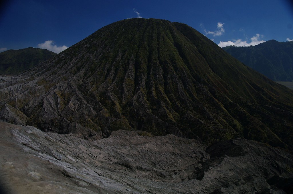
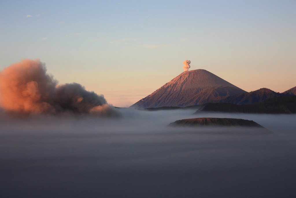
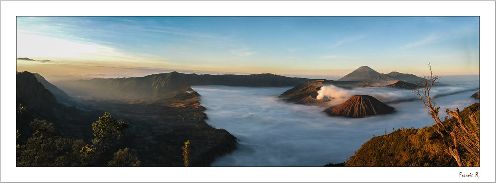
Approaching Mount Batok, the striking silhouette of this cinder cone rises sharply against the vast Tengger caldera landscape. The trek offers a profound sense of geological wonder, as hikers traverse fine volcanic ash and pumice slopes that contrast vividly with the lush valleys beyond. The mountain’s distinctive coconut shell shape, from which it derives its name, adds a unique character to the journey. Reaching the summit rewards trekkers with breathtaking panoramic views of the surrounding volcanic peaks, including the active Mount Bromo and the towering Mount Semeru. The quiet serenity of this dormant volcano provides a contemplative atmosphere, inviting adventurers to reflect on the immense forces that shaped this dramatic landscape.

The Volcano Itself: Geological Background
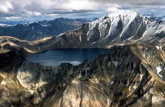
Mount Batok is a classic cinder cone volcano formed by explosive eruptions that ejected volcanic ash, lapilli, and volcanic bombs, which accumulated around the vent to create its steep, conical shape. Situated within the larger Tengger caldera, Mount Batok stands at approximately 2,440 meters above sea level and is one of several volcanic peaks in this geologically active region of East Java. Unlike its neighboring Mount Bromo, which remains active, Mount Batok is dormant, with no recent eruptions recorded. The volcano’s surface is characterized by fine volcanic ash and pumice deposits, with sparse vegetation clinging to its slopes. The caldera itself is a result of massive volcanic activity that created a vast depression surrounded by multiple volcanic cones. Local legends attribute Mount Batok’s formation to mythical tales involving giants and coconut shells, adding cultural depth to its geological significance.
The Volcano Trek: Terrain and Hiking Experience
Trekking Mount Batok offers a rewarding experience that combines moderate physical challenge with stunning natural beauty. The trail begins near the parking area in the Tengger caldera and ascends approximately 340 meters to the summit. The terrain is predominantly composed of fine volcanic ash and loose pumice, which can make footing unstable and requires careful attention to balance and step placement. The steep slopes resemble climbing a sand dune, where each step may cause the ground beneath to shift, demanding a steady pace and good hiking footwear with solid grip.
The trail is generally well-marked but includes sections where the path narrows and is bordered by fragile dried grasses and occasional overgrown vegetation. Rain can significantly increase the difficulty, making the ash slopes slippery and more prone to erosion, so trekking during the dry season is highly recommended. The ascent is relatively short, typically taking between two to three hours, but the steepness and loose terrain elevate the technical challenge beyond a simple walk.
As hikers climb, they encounter changing microclimates; the base of the mountain is cooler and shaded, while the upper slopes are exposed to wind and sun, with temperatures dropping noticeably near the summit. The wind can be strong and chilling, so layered clothing is advisable. The summit offers an expansive 360-degree view of the Tengger caldera, including the iconic Mount Bromo with its smoking crater and the distant Mount Semeru, Java’s highest peak. The panoramic vistas and the unique volcanic landscape make the effort worthwhile, providing excellent opportunities for photography and quiet reflection.
Overall, the Mount Batok trek is suitable for hikers with moderate fitness and some experience on uneven terrain. It is less crowded than Mount Bromo, offering a more solitary and immersive volcanic hiking experience. Trekkers should prepare for the physical demands of the loose ash and steep incline, and bring sufficient water and sun protection due to the exposed nature of the trail.
What Makes This Volcano Trek Unique
Mount Batok stands out for its distinctive shape resembling a coconut shell, a feature that is both visually striking and culturally significant. Unlike many other volcanoes in the region, it is dormant, providing a safer environment for trekkers seeking volcanic landscapes without the immediate risks of eruption. The mountain’s location within the vast Tengger caldera offers unparalleled panoramic views of multiple volcanic peaks, including the ever-smoking Mount Bromo and the majestic Mount Semeru.
The trek’s relative solitude compared to the busier Mount Bromo allows for a more intimate connection with the volcanic environment. The fine volcanic ash terrain presents a unique hiking challenge, akin to climbing a sand dune, which is uncommon among volcano treks. Additionally, the local legends surrounding Mount Batok enrich the experience, blending natural wonder with cultural storytelling. Photographers and nature lovers will appreciate the contrasting colors and textures of the volcanic ash, sparse vegetation, and dramatic sky, making Mount Batok a compelling destination for both adventure and contemplation.
The Summit and Crater Experience
Reaching the summit of Mount Batok is a moment of awe and tranquility. From this vantage point, hikers are rewarded with sweeping views across the Tengger caldera, where the active Mount Bromo emits a steady plume of white smoke. The crater of Mount Batok itself is dormant and overgrown, offering a stark contrast to the dynamic activity nearby. The air at the summit is crisp and often carries the faint scent of volcanic minerals.
The panoramic landscape stretches to include the rolling Sea of Sand, a vast plain of volcanic ash that surrounds the caldera floor, and the towering silhouette of Mount Semeru in the distance. The summit’s exposure to wind and open sky creates a sense of standing on the edge of a geological masterpiece shaped by millennia of volcanic activity. The quiet here invites reflection on the power and beauty of Earth’s volcanic forces, making the summit experience both visually and emotionally compelling.
Best Time to Trek Mount Batok
The optimal time to trek Mount Batok is during the dry season, which runs from May to October. During these months, the weather is generally clear and stable, providing excellent visibility and safer trail conditions. The volcanic ash slopes become significantly more treacherous in the rainy season due to mud and slippery surfaces, increasing the risk of falls.
Early morning treks are recommended to avoid the midday heat and to enjoy the cooler temperatures and softer light for photography. The dry season also coincides with clearer skies, enhancing the panoramic views from the summit. Visitors should be prepared for chilly temperatures before sunrise and warmer conditions as the day progresses. It is advisable to check local weather forecasts and volcanic activity reports before planning a trek, although Mount Batok’s dormant status means sudden volcanic hazards are unlikely.
Trekking Routes and Trail Options
The primary route to the summit of Mount Batok starts from the parking area near the Tengger caldera floor, accessible via the village of Cemoro Lawang or Tosari. The trail is a direct ascent of approximately 340 meters in elevation gain, covering a distance that can be completed in two to three hours round trip.
The path is well-marked but steep, winding through volcanic ash and pumice terrain. There are no alternative routes to the summit, making the trek straightforward in terms of navigation. However, hikers can combine the Mount Batok trek with visits to nearby attractions such as Mount Bromo’s crater rim and various viewpoints like King Kong Hill and Teletubbies Hill.
Guided tours often include Mount Batok as part of a broader itinerary encompassing the Bromo Tengger Semeru National Park. These tours typically provide transportation from major cities such as Surabaya or Malang, and include park entrance fees and local guides. Independent trekkers can access the trailhead by jeep or motorbike from Cemoro Lawang, with parking available near the base.
While the Mount Batok trail itself is short, it is technically challenging due to the loose volcanic ash and steep incline. Trekkers should allocate sufficient time for ascent and descent, and consider weather conditions that may affect trail safety. Combining the Mount Batok trek with sunrise or sunset visits to Mount Bromo offers a comprehensive volcanic experience in the Tengger caldera.
Difficulty Assessment
Mount Batok is classified as an easy to intermediate volcano trek. The trail is relatively short but features a steep ascent over loose volcanic ash and pumice, which requires good balance and moderate fitness. The unstable terrain can be physically demanding, especially for those unaccustomed to hiking on loose surfaces.
Altitude is moderate at 2,440 meters, so altitude sickness is generally not a concern for most trekkers. However, the exposed nature of the trail means hikers should be prepared for wind and temperature fluctuations. No technical climbing skills or equipment are required, but sturdy hiking boots with good grip and trekking poles are recommended to aid stability.
Overall, the trek is suitable for hikers with some experience on uneven terrain and a reasonable level of fitness. Beginners should proceed with caution and consider hiring a local guide for added safety and navigation assistance.
Essential Volcano Trekking Gear
For trekking Mount Batok, essential gear includes sturdy hiking boots with excellent grip to handle the loose volcanic ash and pumice. Trekking poles are highly recommended to assist with balance on the steep and unstable slopes. Layered clothing is important to adapt to temperature changes, including a windproof jacket for summit exposure and a moisture-wicking base layer.
A headlamp or flashlight is useful for early morning or late afternoon hikes when light is low. Sun protection is critical due to the lack of shade on the trail; bring sunscreen, sunglasses, and a wide-brimmed hat. Carry sufficient water to stay hydrated, as there are no water sources along the route.
A small first aid kit, snacks, and a camera to capture the stunning views are also advisable. While volcanic gases are minimal due to Mount Batok’s dormant status, sensitive individuals may still consider a lightweight mask. Finally, a map or GPS device can help with orientation, although the trail is generally well-marked.
Safety and Volcanic Hazards
Mount Batok is a dormant volcano, which significantly reduces the risk of volcanic hazards such as eruptions or toxic gas emissions. However, trekkers should remain cautious of the unstable terrain, particularly the loose volcanic ash and pumice that can cause slips and falls. The steep slopes require careful footing and attention to trail conditions.
Weather can change rapidly in the highlands, with strong winds and sudden temperature drops near the summit. Hypothermia risk exists during early morning or late evening treks if not properly equipped. There are no active fumaroles or steam vents on Mount Batok, but nearby Mount Bromo is active and monitored by local authorities.
Visitors should heed warnings from the Bromo Tengger Semeru National Park officials and avoid venturing into restricted areas. It is advisable to check volcanic activity updates before planning a visit. Emergency services are limited in the area, so trekking with a guide or in a group enhances safety. Carrying a basic first aid kit and informing others of your itinerary is recommended.
Permits, Guides, and Logistics
Mount Batok is located within the Bromo Tengger Semeru National Park, and all visitors are required to purchase an entrance ticket to access the park. Tickets must be bought online in advance through the official TNBTS website, as on-site sales are not available. The ticket system operates on a quota basis, especially during peak months such as July and August, so early planning is essential.
Several reputable tour operators offer packages that include Mount Batok trekking combined with visits to Mount Bromo and other nearby attractions. Notable operators include AOMIndonesia Tour and Adventure, Thalia Travel, Bromo Solution, Java Volcano Tour Operator (JVTO), Indo Travel Team, and Blue Flame Tours. These operators provide transportation from major cities like Surabaya and Malang, professional guides, park entrance fees, and accommodation arrangements.
Independent travelers can reach the trailhead via the village of Cemoro Lawang, which serves as the main gateway to the Tengger caldera. From Cemoro Lawang, jeep rentals or motorbike taxis are available to reach the base of Mount Batok. The village offers basic amenities and lodging options.
Guided treks are recommended for those unfamiliar with volcanic terrain or seeking cultural insights, as local guides provide valuable knowledge about the geology, legends, and safety. The trekking season aligns with the dry months from May to October, when trail conditions are optimal.
Visitors should prepare for early morning departures to avoid midday heat and to experience the best light for photography. Park regulations emphasize environmental preservation and respect for local customs, including the Tenggerese Hindu community’s sacred sites. Adhering to these rules ensures a safe and responsible trekking experience.
Where to Stay Near Mount Batok
The primary base for trekking Mount Batok is the village of Cemoro Lawang, located on the edge of the Tengger caldera. Cemoro Lawang offers a range of accommodations catering to different budgets, from simple guesthouses to mid-range hotels. Popular options include the Lava View Lodge, Bromo Permai Hotel, and Jiwa Jawa Resort, all providing comfortable rooms with views of the volcanic landscape.
These accommodations offer essential amenities such as hot showers, Wi-Fi, and dining facilities serving local Indonesian cuisine. Staying in Cemoro Lawang allows easy access to the Mount Batok trailhead and other key points in the national park, including Mount Bromo and various viewpoints.
For travelers seeking a more immersive experience, camping options are available near the caldera floor, though facilities are basic and require self-sufficiency. The village of Tosari, located about 53 kilometers from Pasuruan City, is another nearby settlement offering lodging and access routes to Mount Batok, though it is less frequented by tourists.
Probolinggo and Malang are larger towns within a two to three-hour drive from the park, providing additional accommodation choices, restaurants, and transport connections. These towns serve as logistical hubs for travelers arriving by train or bus from Surabaya and other major cities.
Booking accommodations in advance is advisable during peak seasons to secure availability. Many hotels and lodges in Cemoro Lawang also offer tour packages and transportation services, facilitating seamless planning for Mount Batok and surrounding volcano treks.