
Mount Sinabung Volcano Trekking: A Complete Guide to Indonesia’s Most Active Stratovolcano
Mount Sinabung, an active stratovolcano in North Sumatra, Indonesia, offers a demanding and thrilling trekking experience. This guide covers its geology, trekking terrain, routes, safety, permits, and accommodation options near the volcano.
Quick Volcano Snapshot
| Attribute | Value |
|---|---|
| Volcano type | Stratovolcano |
| Elevation | 2460 m |
| Location | North Sumatra, Indonesia |
| Activity status | Active |
| Trekking difficulty | Demanding |
| Typical trek duration | 6-8 hours round trip |
| Altitude gain | Approx. 1000 m |
| Terrain type | Dense jungle, rocky gullies, volcanic ash and lava fields |
| Best season | May to September (dry season) |
| Temperature range | 10°C to 25°C |
| Permit requirement | Required with local guide |
Introduction: The Experience of Hiking Mount Sinabung
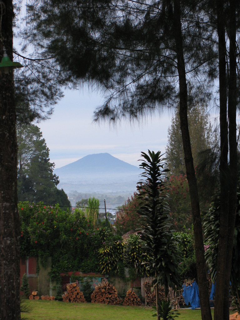
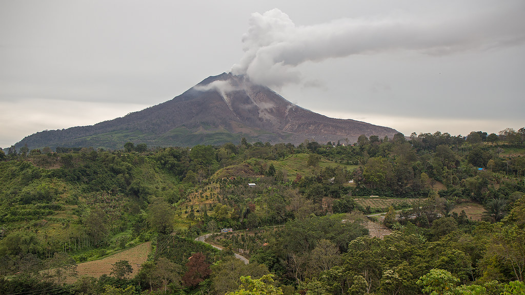
Approaching Mount Sinabung, the landscape shifts dramatically from lush tropical forests to stark volcanic terrain. The air carries a faint sulfuric tang, hinting at the mountain’s restless nature. Hiking this active volcano is a raw encounter with geological power, where every step brings you closer to the earth’s molten heart. The trail challenges your endurance as you ascend through dense jungle, then scramble over rocky gullies and ash slopes. Reaching the summit rewards you with panoramic views of the surrounding Karo Highlands, the vast Lake Toba, and the steaming craters below. The emotional intensity of standing on the edge of an active volcano, feeling the heat and hearing the distant rumble, is unmatched in the world of trekking.
The Volcano Itself: Geological Background
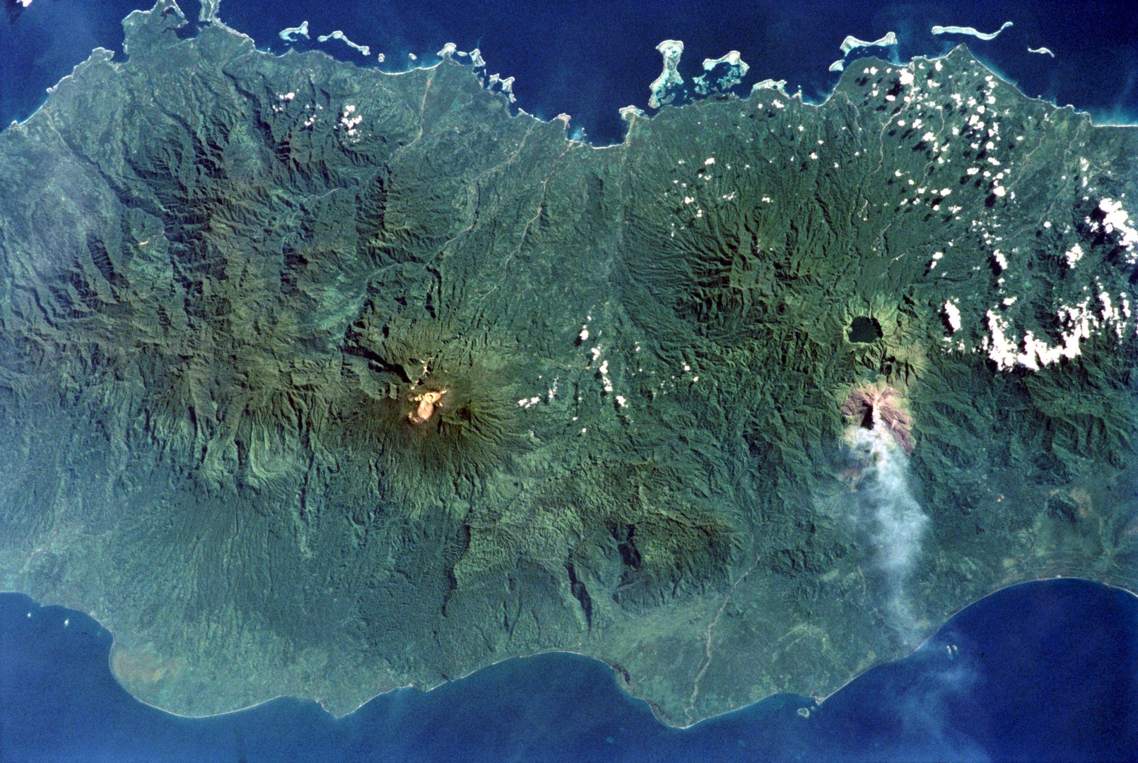
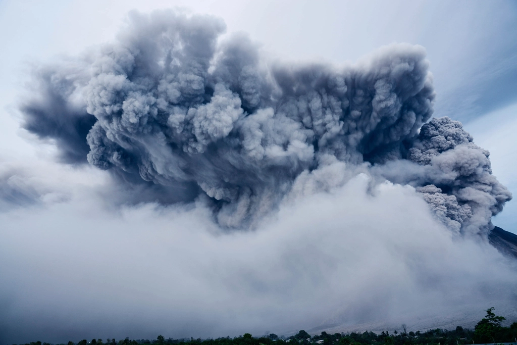
Mount Sinabung is a stratovolcano composed primarily of andesite and dacite, located on the Karo plateau in North Sumatra. It rises to 2,460 meters and is part of the Bukit Barisan mountain range. The volcano’s formation dates back to the Pleistocene, with Holocene activity shaping its current structure. After centuries of dormancy, Sinabung erupted explosively in August 2010, marking the start of a highly active phase that continues intermittently. Its eruptions have produced pyroclastic flows, ash plumes reaching several kilometers high, and lava domes. The volcano features multiple craters and fumaroles emitting steam and sulfur gases. The surrounding landscape is marked by fresh lava flows and volcanic minerals, creating a dynamic environment that is both beautiful and hazardous.
The Volcano Trek: Terrain and Hiking Experience
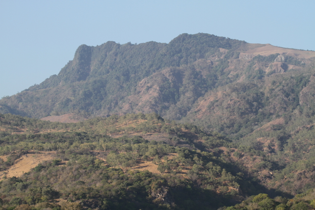
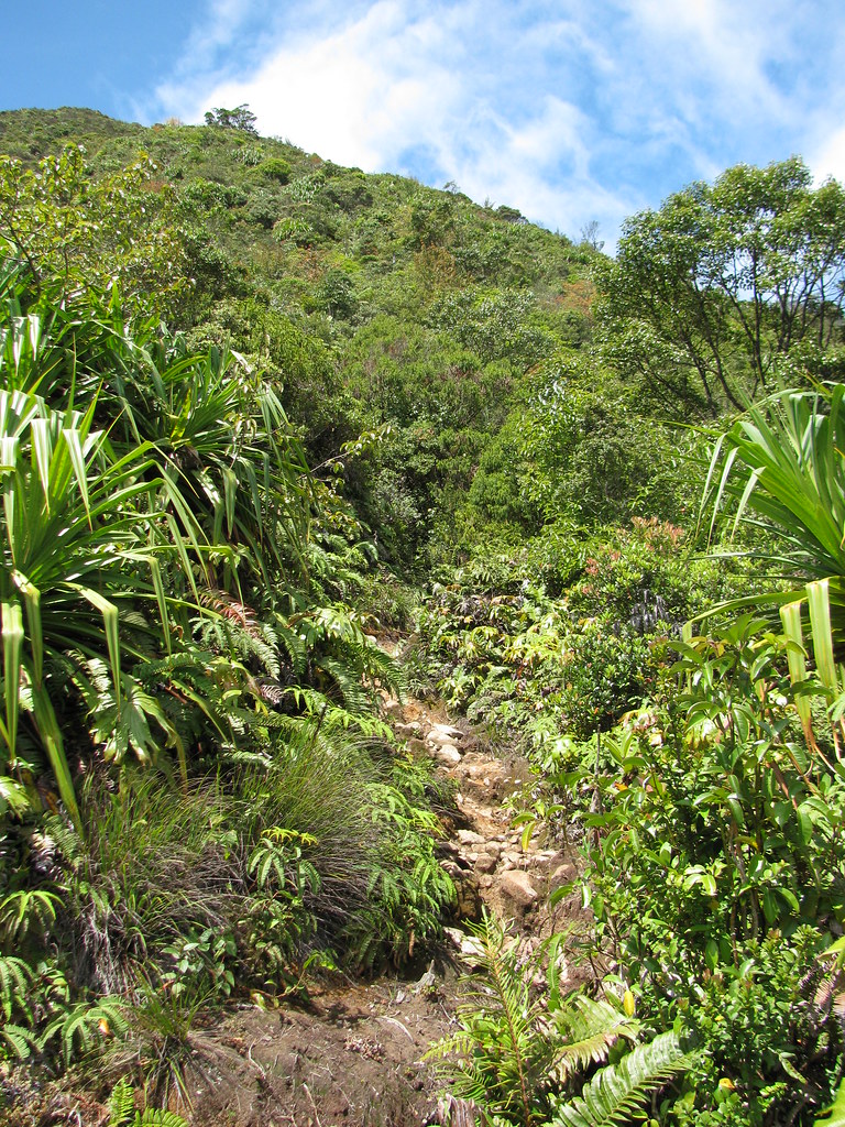
The trek up Mount Sinabung is a demanding adventure that tests both physical endurance and mental resilience. The ascent begins at Lake Lau Kawar, situated at approximately 1,460 meters elevation, where the trail initially winds through dense tropical jungle. This section is humid and buggy, with thick vegetation and occasional muddy patches. Hikers should be prepared for insects and leeches, especially during the rainy season. As you climb higher, the forest thins and the terrain becomes steeper and rockier. The trail transitions into a rocky gully strewn with loose volcanic debris, requiring careful footing and some scrambling skills. The volcanic ash and pumice make the ground slippery, and strong winds near the summit add to the challenge. The final hour of the climb feels more like rock climbing, with jagged lava rocks and sharp ridges. Altitude effects may be felt above 2,000 meters, so pacing and hydration are crucial. The trail is not well marked beyond the jungle section, so a knowledgeable local guide is essential to navigate safely. Weather can change rapidly, with mist and rain reducing visibility and increasing the risk of slips. Despite these challenges, the trek offers spectacular views of the crater, fumaroles, and the surrounding highlands. The volcanic terrain is raw and ever-changing, shaped by recent eruptions that have altered the landscape. Descending requires caution as loose scree and ash slopes can cause sliding. Overall, the hiking experience is intense and rewarding, suited for experienced trekkers seeking a true volcanic adventure.
What Makes This Volcano Trek Unique
Mount Sinabung stands out for its status as one of Indonesia’s most active volcanoes, with frequent eruptions since 2010. This ongoing activity creates a dynamic and unpredictable environment that few volcano treks can match. The volcano’s multiple craters and steaming fumaroles provide a vivid display of volcanic power. Unlike dormant volcanoes, Sinabung’s landscape is constantly reshaped by fresh lava flows and pyroclastic deposits, offering a rare glimpse into geological processes in action. The trek also passes near ghost villages abandoned due to eruptions, adding a poignant cultural dimension. The panoramic views from the summit include the vast caldera of Lake Toba and the lush Karo Highlands, contrasting sharply with the barren volcanic slopes. This combination of active geology, dramatic scenery, and cultural history makes Mount Sinabung a uniquely compelling destination for adventurous trekkers.
The Summit and Crater Experience
Reaching the summit of Mount Sinabung is a moment of awe and exhilaration. The expansive crater stretches before you, with steam rising from fumaroles and sulfur vents that emit a pungent, acrid smell. The ground beneath your feet is warm in places, a reminder of the molten forces below. The air is often filled with the low rumble of volcanic activity and the occasional sharp crack of shifting rocks. On clear days, the summit offers breathtaking views of Lake Toba’s shimmering waters, the surrounding forested hills, and neighboring volcanoes like Gunung Sibayak. The jagged rim of the crater frames the scene, creating a dramatic foreground for photography. The experience is sensory and intense — the heat, the smell, the sounds, and the vast panorama combine to create a powerful connection to the earth’s inner workings.
Best Time to Trek Mount Sinabung
The optimal time to trek Mount Sinabung is during the dry season, from May to September, when weather conditions are more stable and trails are less muddy. During this period, the risk of heavy rain and slippery terrain is reduced, making the ascent safer and more enjoyable. However, due to the volcano’s active status, trekkers must always check the latest volcanic activity reports and heed warnings from local authorities. Eruptions can occur unpredictably, and access may be restricted during heightened activity. Early morning climbs are common to avoid afternoon thunderstorms and to reach the summit for sunrise views. Avoid the monsoon season from October to April, as heavy rains increase the risk of landslides and make the trail more hazardous. Always plan your trek with flexibility to accommodate sudden changes in volcanic activity or weather.
Trekking Routes and Trail Options
Mount Sinabung offers several trekking routes, though the most commonly used trail starts at Lake Lau Kawar, north of the volcano. This trail begins at approximately 1,460 meters elevation and ascends roughly 1,000 meters to the summit at 2,460 meters. The route passes through dense jungle, volcanic ash slopes, and rocky gullies. The trail is challenging and requires a good level of fitness and experience with rugged terrain. There are two other less marked routes, but these are not recommended without an experienced guide due to the risk of getting lost and unstable terrain. Guided treks are strongly advised, as local guides provide safety, navigation, and insight into the volcano’s geology and history. The typical trek duration is 6 to 8 hours round trip, with an early start to reach the summit by sunrise. Due to ongoing volcanic activity, trail conditions can change rapidly, and some sections may be closed temporarily. It is essential to confirm current trail status with local authorities or tour operators before planning your hike.
Difficulty Assessment
Mount Sinabung is classified as a demanding volcano trek. The terrain includes steep ascents through dense jungle, slippery volcanic ash, loose rocks, and rocky gullies requiring scrambling skills. Altitude gain of approximately 1,000 meters over a relatively short distance challenges cardiovascular endurance. The trail is not well marked beyond the forested section, necessitating a local guide for safe navigation. Weather conditions can add difficulty, with strong winds near the summit and sudden rain showers. The active volcanic status introduces additional hazards such as ashfall and unstable ground. This trek is suitable for experienced hikers with good fitness and some technical hiking ability. It is not recommended for beginners or those with respiratory or mobility issues.
Essential Volcano Trekking Gear
For trekking Mount Sinabung, essential gear includes sturdy hiking boots with good grip to handle slippery ash and rocky terrain. Trekking poles are recommended to aid balance and reduce strain on knees during steep ascents and descents. A windproof and waterproof jacket is necessary due to unpredictable weather and strong summit winds. Headlamps are essential for early morning starts in darkness. Carry sufficient water (at least 2 liters) and high-energy snacks. A face mask or respirator is advisable to protect against volcanic ash and sulfur gases. Lightweight long pants and long-sleeved shirts help protect against insects and vegetation in the jungle section. A hat, sunglasses, and sunscreen are important for sun protection as the trail opens above the tree line. A small first aid kit, insect repellent, and a map or GPS device are also recommended. Always pack out all trash to preserve the fragile environment.
Safety and Volcanic Hazards
Mount Sinabung’s active status presents significant safety challenges. Volcanic gases such as sulfur dioxide can cause respiratory irritation, so trekkers should carry masks and avoid areas with strong gas emissions. The crater rim and upper slopes have unstable edges prone to collapse, requiring caution. Loose volcanic ash and pumice create slippery conditions, increasing the risk of falls. Pyroclastic flows and ashfall can occur suddenly during eruptions, making it critical to monitor volcanic activity reports from the Indonesian Center of Volcanology and Geological Hazard Mitigation (PVMBG). Emergency evacuation routes and procedures should be known before the trek. Weather changes rapidly, with fog and rain reducing visibility and increasing hypothermia risk. Hiring experienced local guides is essential for navigating hazards and responding to emergencies. Trekkers should have adequate fitness, carry communication devices, and avoid solo hiking. Always respect park regulations and closures for your safety.
Permits, Guides, and Logistics
Due to Mount Sinabung’s active volcanic status and associated hazards, trekking is regulated and requires permits issued by local authorities. Visitors must hire licensed local guides who are familiar with current trail conditions, volcanic activity, and safety protocols. Permits typically include park entry fees and guide services, with costs varying depending on the tour operator and group size. Gumilang Tours, Berastagi Adventure, Trijaya Travel, and Getaway Tours Indonesia are reputable operators offering guided treks with comprehensive safety measures and logistical support. These companies provide transportation from Medan or Berastagi to trailheads, arrange accommodation, and supply necessary equipment. It is essential to book tours in advance, especially during the dry season, as access may be restricted during heightened volcanic activity. Guides also assist with emergency planning and communication with authorities. Visitors should prepare for early morning starts and variable weather. Organizing transport independently is possible but less recommended due to the complexity of the region and safety concerns. Always check the latest volcanic activity reports from PVMBG before planning your trek. The permit process is straightforward when booking through tour operators, who handle all paperwork and ensure compliance with regulations. This system helps protect both visitors and local communities while preserving the fragile volcanic environment.
Where to Stay and Nearby Bases
The town of Berastagi, located approximately 20 kilometers south of Mount Sinabung, serves as the primary base for trekkers. Berastagi sits at around 1,200 meters elevation and offers a cool climate, making it an ideal place to acclimatize before the climb. Accommodation options in Berastagi range from budget guesthouses to mid-range hotels. Popular choices include Rudang Hotel & Resort Berastagi, which features rooms with private balconies and free Wi-Fi, and Hotel Miranda at Desa Wisata Berastagi, known for its 24-hour front desk and convenient location. For budget travelers, RedDoorz properties such as RedDoorz @ Jalan Ujung Aji Berastagi provide affordable rooms with basic amenities. Many hotels can arrange local guides and transportation to the trailhead at Lake Lau Kawar. The trailhead itself is accessible by a 30- to 45-minute drive from Berastagi, with parking available near the start. For those seeking a more immersive experience, camping near Lake Lau Kawar is possible but requires prior arrangement and permits. The nearby town of Kabanjahe also offers guesthouses and is an alternative base. After the trek, visitors can relax at natural hot springs near Berastagi, such as Lau Sidebuk-Debuk, which provide soothing geothermal baths with views of the surrounding mountains. Dining options in Berastagi include local markets and restaurants serving traditional Karo cuisine. Overall, Berastagi’s combination of accessibility, amenities, and scenic beauty makes it the preferred hub for Mount Sinabung expeditions.