
Mount Manucoco Volcano Trekking Guide: Conquer Timor-Leste’s Sacred Peak on Atauro Island
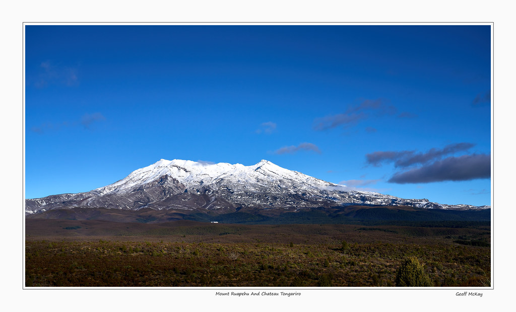
Mount Manucoco, the highest peak on Atauro Island in Timor-Leste, offers a challenging and rewarding volcano trek through diverse tropical forests and rugged terrain. This guide covers the geological background, trekking routes, essential gear, safety tips, and local logistics to help adventurers prepare for an unforgettable ascent of this sacred stratovolcano.
Quick Volcano Snapshot
| Attribute | Value |
|---|---|
| Volcano type | Stratovolcano |
| Elevation | 995 meters (3,264 feet) |
| Location | Atauro Island, Oecusse Special Administrative Region, Timor-Leste |
| Activity status | Dormant |
| Trekking difficulty | Moderate |
| Typical trek duration | 6 to 10 hours roundtrip |
| Altitude gain | Approximately 963 meters |
| Terrain type | Steep rocky paths, tropical semi-evergreen forest, grassy slopes, narrow ridges |
| Best season | May to November (dry season) |
| Temperature range | Warm tropical climate with hotter conditions near sea level and cooler forested summit |
| Permit requirement | Guide required due to sacred status and trail conditions |
Introduction: The Experience of Hiking Mount Manucoco
Approaching Mount Manucoco, the highest and most sacred peak on Atauro Island, immerses you in a landscape of raw natural beauty and cultural reverence. The trek begins in the coastal village of Vila, winding upward through changing vegetation zones—from dry grassy slopes to lush tropical forests alive with vibrant birdlife. The rugged terrain and steep ascents challenge your endurance, while the panoramic views of the surrounding Wetar Strait and coral reefs reward your effort. Reaching the summit, you stand atop a sacred mountain revered by local communities, feeling the profound connection between the island’s geological past and its living traditions. The contrast between the island’s coastal serenity and the mountain’s wild interior creates a powerful sense of adventure and discovery.
Geological Background of Mount Manucoco
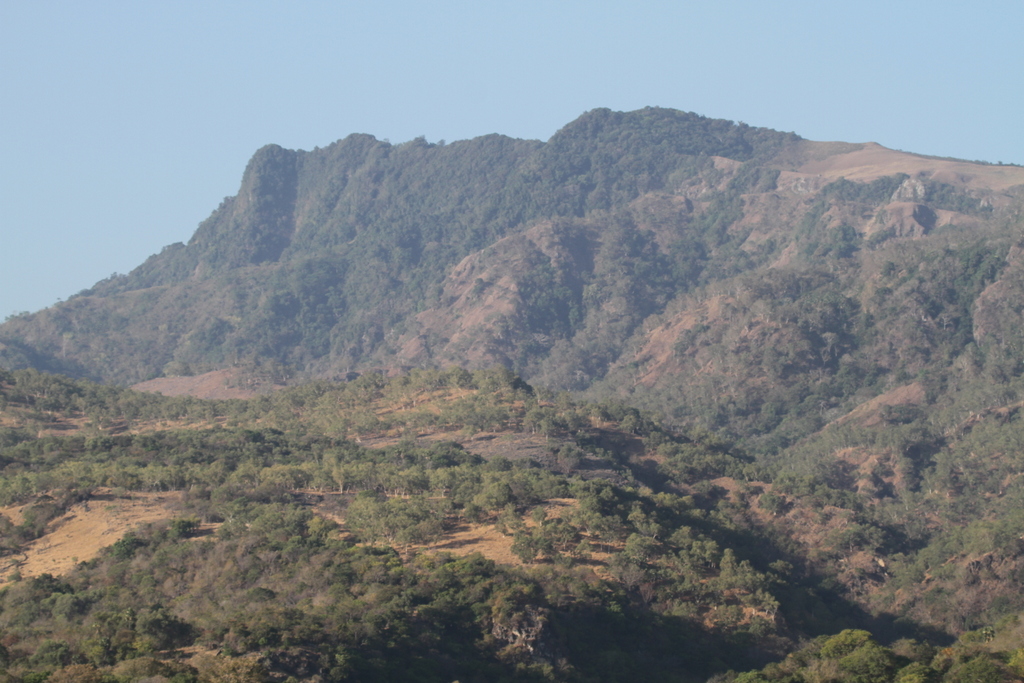
Mount Manucoco is a stratovolcano formed during the Neogene period as part of a series of submarine volcanoes uplifted and eroded over millions of years. Its rugged topography features narrow, dissected ridges and steep slopes shaped by volcanic activity and subsequent erosion. The mountain rises to approximately 995 meters above sea level, making it the highest point on Atauro Island. The upper elevations retain patches of tropical semi-evergreen mountain forest, which thrive in sheltered valleys. These forests contribute to the island’s rich biodiversity, supporting several restricted-range bird species unique to Timor and Wetar. Although currently dormant, the volcano’s geological features include rocky ridges and volcanic rock formations interspersed with limestone, reflecting its complex volcanic and tectonic history. The mountain’s formation and ongoing erosion create a dramatic landscape that fascinates geologists and trekkers alike.
The Volcano Trek: Terrain and Hiking Experience
The trek to Mount Manucoco’s summit is a physically demanding journey that tests both endurance and agility. Starting from Vila, hikers initially ascend a steep paved road passing landmarks such as the Cave of Our Lady Mary. Soon, the trail diverges onto a rugged path that climbs sharply through dry, grassy slopes. As elevation increases, the terrain transitions into dense tropical semi-evergreen forest, where the canopy provides welcome shade and the air fills with the sounds of exotic bird calls. The trail is often narrow, rocky, and uneven, requiring careful footing and sturdy hiking boots. Sections of the path include steep ascents over loose stones and scrambling along narrow ridges covered in scrub and volcanic rock. The final approach to the summit ridge involves negotiating a rocky, scrub-covered ridge that demands balance and concentration. The descent can be even more challenging due to slippery surfaces and steep gradients, making trekking poles highly recommended. Weather conditions vary, with hot temperatures near sea level and cooler, humid conditions in the forested upper reaches. Hikers should be prepared for sudden changes in weather and carry sufficient water, sunscreen, and protective clothing. The trail is not well-marked in places, so hiring a local guide is essential for navigation and safety. Along the way, trekkers experience a rich variety of flora and fauna, including endemic birds such as the endangered Timor Green Pigeon. Rest stops at culturally significant sites and scenic viewpoints provide opportunities to appreciate the island’s natural and cultural heritage. Overall, the terrain offers a rewarding blend of physical challenge and immersive nature experience, making the Mount Manucoco trek a must for seasoned hikers seeking an off-the-beaten-path adventure.
What Makes the Mount Manucoco Trek Unique
Mount Manucoco stands out for its combination of geological significance, rich biodiversity, and cultural importance. Unlike many volcano treks dominated by barren lava fields, this ascent traverses vibrant tropical forests that harbor rare and endemic bird species, making it a hotspot for birdwatchers and nature lovers. The mountain’s sacred status among the local Ataúro communities adds a profound cultural dimension, with traditions and legends woven into the landscape. The trek offers spectacular coastal views of the Wetar Strait and surrounding islands, providing a striking contrast between lush mountain greenery and turquoise waters. The challenging terrain, including steep ridges and rocky paths, demands physical fitness and agility, rewarding hikers with a sense of accomplishment and solitude rarely found on more commercialized volcano hikes. The requirement to hike with a local guide ensures an authentic experience enriched by indigenous knowledge and respect for the mountain’s spiritual significance.
The Summit and Crater Experience
Reaching the summit of Mount Manucoco is a moment of awe and reflection. From the peak, hikers are treated to sweeping panoramic views of Atauro Island’s rugged interior, the surrounding Wetar Strait, and distant islands shimmering under the tropical sun. The summit ridge is a narrow, rocky spine offering dramatic vistas in all directions. The air is cooler and carries the fresh scent of forest and sea. Although the volcano is dormant and lacks an active crater, the summit area retains a sacred aura, with local customs discouraging extensive disturbance. The silence is punctuated by bird calls and the rustle of wind through the scrub. The experience is both a physical triumph and a spiritual encounter, connecting trekkers to the island’s natural forces and cultural heritage. Photographers find ample opportunities to capture the interplay of light and shadow across the island’s diverse landscapes.
Best Time to Trek Mount Manucoco
The optimal time to hike Mount Manucoco is during the dry season, from May to November, when trails are less slippery and weather conditions are more stable. During these months, the likelihood of clear skies enhances visibility and the quality of summit views. Trekking in the early morning is advisable to avoid the midday heat, especially since the lower elevations near sea level can become quite hot. The dry season also reduces the risk of sudden rainstorms that can make the steep and rocky paths hazardous. Hikers should be aware that the wet season, from December to April, brings heavy rains that can cause trail erosion, slippery conditions, and increased difficulty. Additionally, local guides may restrict access during adverse weather to ensure safety. Planning your trek around these seasonal patterns maximizes enjoyment and reduces risks.
Trekking Routes and Trail Options on Mount Manucoco
The primary and most established route to Mount Manucoco’s summit begins in the village of Vila Maumeta, the island’s main settlement. From Vila, hikers follow a steep paved road past the Cave of Our Lady Mary before turning onto a rugged trail near Maulaco that ascends sharply toward the peak. This route covers approximately 27 kilometers roundtrip and typically takes between 6 to 10 hours, depending on fitness and pace. The trail passes through diverse vegetation zones, including dry grasslands, tropical forests, and rocky ridges. Due to the mountain’s sacred status and challenging terrain, hiking with a local guide is mandatory. Guides provide navigation assistance, cultural insights, and safety support. Alternative access points include joining the trail from Anartutu village, which connects to the main path near the summit ridge. While some trekkers attempt self-guided hikes, the lack of clear signage and the presence of steep, slippery sections make guided treks strongly recommended. The route includes several rest stops, such as Fatuk Batas, a culturally significant border rock, and Aldeia Antiga, an old village offering scenic views and refreshments. Transport options to the trailhead include tuk-tuks from Vila, facilitating access for visitors staying in local accommodations. Overall, the route offers a comprehensive experience of Atauro’s natural and cultural landscapes, combining physical challenge with immersive exploration.
Difficulty Assessment of the Mount Manucoco Trek
Mount Manucoco presents a moderate to demanding volcano trek suitable for experienced and relatively fit hikers. The trail features steep ascents and descents, uneven rocky paths, and narrow ridges that require good balance and surefootedness. The altitude gain of approximately 963 meters over a relatively short distance results in sustained physical exertion. The tropical climate adds heat stress, especially at lower elevations. Technical climbing skills are not required, but trekking poles and sturdy footwear with excellent grip are essential for safety. The trail is not well-marked in places, increasing the importance of a knowledgeable local guide. Fitness levels should include endurance for a full day of hiking, as the roundtrip can take between 6 to 10 hours. Hikers with limited experience on rugged terrain or those prone to heat exhaustion should prepare accordingly or consider alternative activities. Overall, the trek is classified as a moderate volcano trek with demanding sections, rewarding those who are well-prepared with spectacular natural and cultural experiences.
Essential Gear for Trekking Mount Manucoco
Successful trekking on Mount Manucoco requires gear tailored to tropical volcanic terrain and variable weather. Essential items include sturdy hiking boots with strong grip to navigate rocky and slippery paths safely. Trekking poles are highly recommended to aid balance on steep ascents and descents. Due to the tropical sun exposure, sunscreen, a wide-brimmed hat, and UV-protective clothing are necessary to prevent sunburn. Carrying at least 2 liters of water per person is critical to stay hydrated during the strenuous climb. Lightweight, breathable clothing suited for warm conditions and a light rain jacket for sudden showers in the forested upper reaches are advisable. A first-aid kit with blister treatment, insect repellent, and any personal medications should be included. Since the trail is not well-marked, a GPS device or map, along with a local guide, enhances navigation safety. A headlamp or flashlight is useful for early morning starts or late returns. Snacks or energy bars provide necessary fuel for the long day. Finally, a camera or smartphone is recommended to capture the stunning vistas and unique biodiversity encountered along the route.
Safety and Volcanic Hazards on Mount Manucoco
Mount Manucoco is a dormant stratovolcano with no recent volcanic activity, minimizing risks from eruptions or volcanic gases. However, the trek presents several safety considerations. The steep and uneven terrain includes loose rocks, narrow ridges, and slippery sections, increasing the risk of falls and injuries. Hikers should wear appropriate footwear and use trekking poles for stability. Sudden weather changes, including tropical rain showers, can make trails hazardous and reduce visibility. Heat and dehydration are concerns at lower elevations, so carrying sufficient water and taking breaks is essential. The trail is not well-marked, so hiring a local guide is mandatory to prevent getting lost and to respect the mountain’s sacred status. Wildlife encounters are generally low risk, but awareness of local fauna and insects is advised. Emergency communication options may be limited on the island, so informing others of your itinerary and expected return time is prudent. Overall, adherence to safety guidelines, proper preparation, and respect for local customs ensure a safe and rewarding trekking experience.
Permits, Guides, and Logistics for Mount Manucoco Trekking
Trekking Mount Manucoco requires careful logistical planning due to the mountain’s sacred status and challenging terrain. A local guide is mandatory for all hikes, both to ensure safety on the rugged, poorly marked trails and to honor cultural protocols. Guides are knowledgeable about the route, local flora and fauna, and the mountain’s spiritual significance. Hiring a guide typically costs around US$20 for the entire trek. Several reputable tour operators offer guided hikes to Mount Manucoco, including Timor Unearthed, Sharing Bali & Beyond, and Manny Timor Tours. These companies provide comprehensive packages that often include transportation to Vila, guide services, picnic lunches, water, and cultural insights. The hike usually starts from Vila Maumeta village, accessible by boat from Dili, Timor-Leste’s capital. Public ferries run several times weekly, taking two to three hours, while private boat charters offer faster but more expensive options. Upon arrival, accommodations can be arranged in Vila or nearby villages. No formal permits are required, but respecting local customs and environmental conservation rules is essential. Visitors should prepare for a full day of hiking, carrying sufficient water, sun protection, and snacks. Booking tours in advance is recommended, especially during the dry season from May to November, to secure guides and transport. Overall, the combination of local guides and established tour operators ensures a safe, culturally respectful, and enriching trekking experience on Mount Manucoco.
Where to Stay and Nearby Bases for Mount Manucoco Trekking
The primary base for trekking Mount Manucoco is Vila Maumeta, the main village on Atauro Island. Vila offers several accommodation options catering to different traveler preferences. Manucoco Rek Guesthouse & Restaurant is a popular choice, run by a women’s cooperative and supported by an Italian Catholic priest. It features traditional thatched bungalows with options for private or shared bathrooms, equipped with fans and mosquito nets. The guesthouse includes an open-air restaurant serving both Italian and traditional Timorese cuisine, a small library, and snorkeling gear for guests. Its central location in Vila places it close to souvenir shops and the trailhead for Mount Manucoco. Another notable option is Barry’s Place Eco-Lodge, which emphasizes sustainable tourism and offers a welcoming atmosphere with local cultural experiences. For travelers seeking a more upscale stay, Beloi Beach Hotel Dive Resort, located a short boat ride from Vila, provides modern amenities, private villas, and access to pristine beaches, though it is farther from the mountain trailhead. Accommodation in Vila is generally basic but comfortable, with friendly local staff and essential services. Visitors should book lodging in advance, especially during peak trekking season. Transport options such as tuk-tuks are available to ferry hikers from accommodations to the trail start. Staying in Vila allows trekkers to acclimate, arrange guides, and enjoy the island’s cultural and natural attractions before and after the climb.