

Mount Semeru Volcano Trekking Guide: Conquer Java’s Highest Active Volcano
Mount Semeru, the highest volcano in Java, Indonesia, offers a demanding yet rewarding trekking experience through diverse volcanic landscapes. This guide covers geology, trekking routes, permits, safety, and accommodation for adventurers seeking to summit this iconic stratovolcano.
Quick Volcano Snapshot
| Attribute | Value |
|---|---|
| Volcano type | Stratovolcano |
| Elevation | 3,676 meters (12,060 feet) |
| Location | East Java, Indonesia |
| Activity status | Active |
| Trekking difficulty | Demanding |
| Typical trek duration | 3-4 days |
| Altitude gain | Approximately 1,500 meters from trailhead |
| Terrain type | Volcanic ash slopes, lava fields, savanna, tropical forest |
| Best season | Dry season (May to October) |
| Temperature range | 5°C to 20°C (night to day) |
| Permit requirement | Mandatory permit from Bromo Tengger Semeru National Park |
The Experience of Hiking Mount Semeru
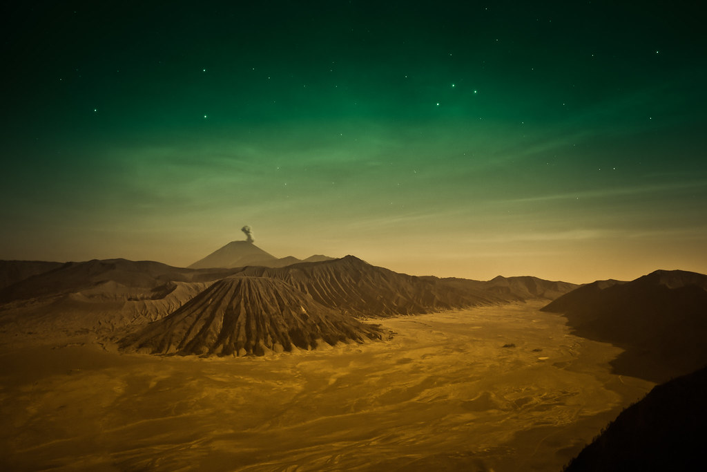
Approaching Mount Semeru, the highest peak on Java, is an encounter with raw geological power. The towering stratovolcano dominates the skyline, its frequent smoke plumes a constant reminder of its active nature. The trek begins in the lush tropical forests and ascends through volcanic savanna and ash-covered slopes. The contrast between fertile farmland at the base and the barren, rugged volcanic terrain near the summit is striking. Reaching the crater rim, hikers are rewarded with panoramic views of East Java and the dramatic sight of Semeru’s periodic eruptions, a sensory experience of heat, sulfur scent, and the sound of rumbling gases. This climb is a profound journey into the heart of an active volcano.
Geological Background of Mount Semeru
Mount Semeru is a classic stratovolcano formed by successive layers of hardened lava, tephra, and volcanic ash. It rises to 3,676 meters, making it the highest mountain on Java and one of Indonesia’s most active volcanoes. Its formation is linked to the subduction of the Indo-Australian Plate beneath the Eurasian Plate, a tectonic process that fuels volcanic activity in the region. Semeru’s summit crater, Jonggring Saloko, frequently emits smoke and ash, with eruptions occurring roughly every 20 minutes. The volcano’s lava flows and pyroclastic deposits have shaped the surrounding landscape, creating fertile soils and unique geological formations. Sulfur deposits and fumaroles near the crater add to the dynamic volcanic environment, making Semeru a living laboratory of volcanic processes.
Terrain and Hiking Experience on Mount Semeru
The trek up Mount Semeru is a challenging adventure that tests endurance and adaptability to diverse volcanic terrain. Starting from the village of Ranupani at about 2,100 meters elevation, hikers traverse agricultural lands and tropical forests before entering the volcanic zone. The trail passes through dense pine and acacia forests, gradually opening to the expansive savanna of Oro-Oro Ombo, a 100-hectare grassland that offers sweeping views of the volcano’s slopes. This section is relatively gentle but can be slippery during the rainy season.
Beyond the savanna, the terrain becomes more demanding. The path climbs steeply through loose volcanic ash and pumice, requiring careful footing and the use of trekking poles for balance. The volcanic ash is fine and powdery, often causing hikers to slide backward during ascent, which adds to the physical challenge. The trail then leads to Kalimati camp at 2,700 meters, a common base for summit attempts.
From Kalimati, the route to the summit is steep and exposed, with loose sand and volcanic debris underfoot. The final ascent involves navigating a rugged ridge with occasional rock scrambling. Altitude effects become noticeable here, with thinner air and cooler temperatures. Wind conditions can be harsh, especially near the crater rim, where volcanic gases are emitted intermittently. Hikers must be prepared for rapid temperature drops and strong winds.
The trail’s volcanic nature means that terrain conditions can change abruptly due to eruptions or landslides. The presence of fumaroles and sulfur vents near the summit adds an element of caution, as toxic gases can accumulate. Overall, the hike demands good physical fitness, proper gear, and respect for the mountain’s volatile environment. Despite the challenges, the diverse landscapes—from lush forests to barren ash fields—offer a rich and immersive trekking experience unique to active volcanoes.
What Makes the Mount Semeru Trek Unique
Mount Semeru stands out as Java’s highest volcano and one of its most active, offering trekkers a rare opportunity to witness volcanic activity up close. The volcano’s frequent eruptions, with smoke and ash emitted every 20 minutes, create a dynamic and dramatic atmosphere. The trek traverses varied ecosystems, from tropical forests and savanna grasslands to stark volcanic ash slopes, showcasing the mountain’s ecological diversity.
The cultural significance of Semeru adds to its uniqueness. Known locally as Mahameru, it holds spiritual importance for the Tenggerese people and other communities, enriching the trekking experience with cultural encounters. The presence of Ranu Kumbolo, a serene volcanic lake nestled within the national park, provides a tranquil contrast to the rugged summit climb.
The combination of challenging terrain, active volcanic phenomena, and cultural heritage makes the Mount Semeru trek a compelling adventure for experienced hikers and geology enthusiasts alike.
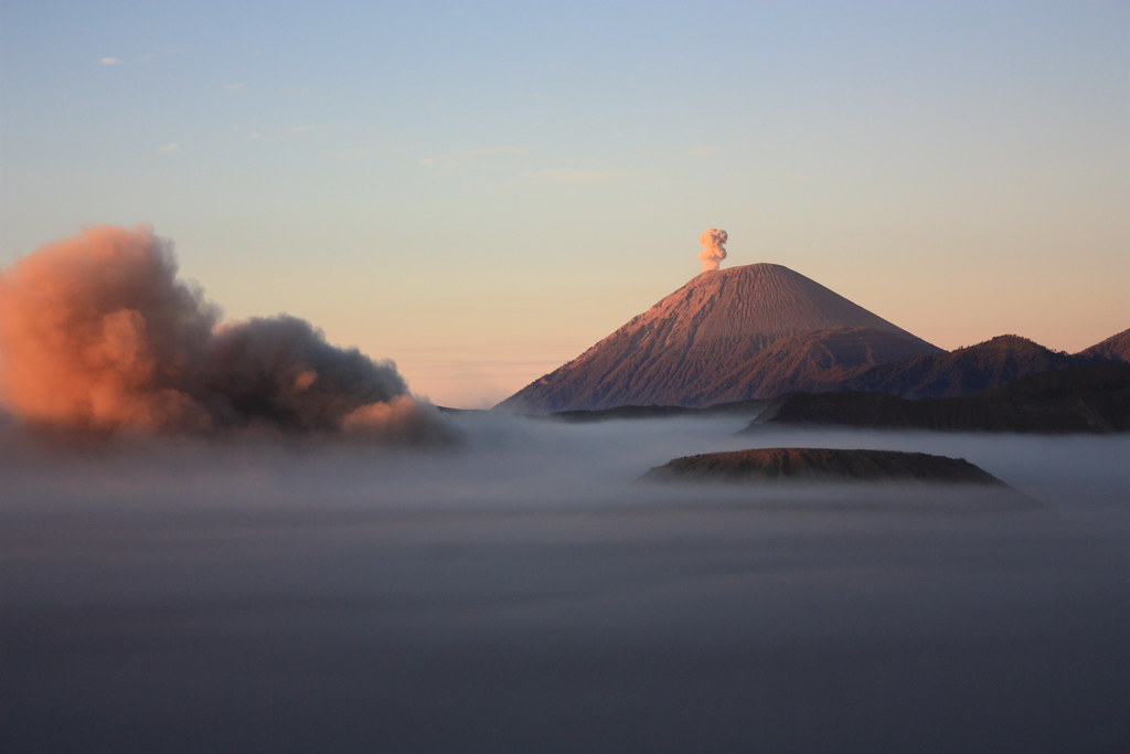
Summit and Crater Experience on Mount Semeru
Reaching the summit of Mount Semeru is a moment of awe and exhilaration. At 3,676 meters, the crater rim offers panoramic views of East Java’s volcanic landscape, including neighboring peaks like Mount Bromo. The summit is often shrouded in mist, with intermittent bursts of smoke and ash from the active crater creating a surreal scene.
The air near the crater carries the sharp scent of sulfur, and the heat from fumaroles can be felt beneath the feet. The sound of escaping volcanic gases adds an eerie soundtrack to the experience. Hikers stand on the edge of a living volcano, witnessing the raw power of Earth’s geological forces. The sunrise from the summit bathes the landscape in golden light, revealing layers of volcanic cones and valleys.
This sensory encounter—sight, smell, sound, and touch—makes the summit experience unforgettable and a highlight of any volcano trek.

Best Time to Trek Mount Semeru
The optimal time to climb Mount Semeru is during the dry season, from May to October, when weather conditions are more stable and trails are safer. Clear skies during this period enhance visibility and summit views. The wet season, from November to April, brings heavy rains that make paths slippery and increase the risk of landslides and trail erosion.
Volcanic activity can also influence trekking windows. The national park authorities monitor Semeru’s activity closely and may close the trail during periods of heightened volcanic unrest. Additionally, the park observes temporary closures during cultural events such as Nyepi and Eid al-Fitr.
Early morning summit attempts, starting around midnight, are recommended to reach the peak by sunrise and descend before volcanic gas concentrations increase later in the day. Hikers should plan accordingly and check current conditions before their trek.
Trekking Routes and Trail Options on Mount Semeru
Mount Semeru’s primary and only official trekking route begins at Ranupani Village, situated at approximately 2,100 meters elevation. This trail is the established path for all summit attempts and is well-maintained by the national park.
The standard itinerary spans 3 to 4 days, with key stops including Ranu Kumbolo Lake and Kalimati Camp. Day one involves trekking from Ranupani through tropical forest and savanna to Ranu Kumbolo, a scenic volcanic lake that serves as a popular camping site. The second day continues to Kalimati Camp, located at 2,700 meters, where hikers rest before the summit push.
The summit ascent typically starts around 1:00 AM from Kalimati, taking 3 to 4 hours to reach the crater rim. The return follows the same route, descending back to Ranupani via a slightly different path passing Mount Ayek-Ayek.
While no alternative official routes exist due to conservation regulations and safety concerns, some tour operators offer combined packages including visits to nearby Mount Bromo and other attractions within Bromo Tengger Semeru National Park.
Guided treks are highly recommended due to the challenging terrain and active volcanic hazards. Permits and registration are required at Ranupani before starting the climb, with a daily quota limiting the number of hikers to 200 to preserve the environment and ensure safety.

Difficulty Assessment of Mount Semeru Trek
Mount Semeru is classified as a demanding volcano trek, suitable for experienced hikers with good physical fitness. The trail involves steep ascents over loose volcanic ash and pumice, which can be physically taxing and require careful footing. Altitude gain from the trailhead at Ranupani to the summit is approximately 1,500 meters, with the summit reaching 3,676 meters.
The terrain includes tropical forest, open savanna, and exposed volcanic slopes, with variable weather conditions including cold temperatures and strong winds near the summit. The loose, sandy ground on the upper slopes can cause slipping and sliding, increasing the effort needed to ascend.
Technical climbing skills are not required, but stamina, endurance, and proper acclimatization are essential. The presence of volcanic gases near the crater rim poses additional risks, making guided treks and adherence to safety protocols crucial.
Overall, Mount Semeru is a challenging but achievable climb for well-prepared trekkers seeking an active volcano experience.
Essential Gear for Mount Semeru Trekking
Successful trekking on Mount Semeru requires gear suited to volcanic terrain and variable weather. Essential items include sturdy hiking boots with good grip for loose ash and rocky paths, and trekking poles to aid balance on slippery slopes.
A waterproof and windproof jacket is necessary to protect against sudden rain and cold summit winds. Layered clothing, including thermal base layers, gloves, and a hat, will help manage temperature fluctuations from warm forested areas to cold high elevations.
A headlamp with extra batteries is vital for the pre-dawn summit climb. Carry at least 3 liters of water per day, as hydration is critical at altitude; water purification tablets or filters are recommended since natural water sources are available but require treatment.
Additional gear includes sun protection (sunscreen, sunglasses), a gas mask or respirator for potential volcanic gases near the crater, a first aid kit, and a backpack sized 40-50 liters to carry essentials. Camping equipment such as tents and sleeping bags are needed for overnight stays at Ranu Kumbolo and Kalimati campsites.
Safety and Volcanic Hazards on Mount Semeru
Mount Semeru’s active status presents inherent risks that require careful preparation and adherence to safety protocols. The volcano emits volcanic gases, including sulfur dioxide, which can be harmful or fatal if inhaled in high concentrations near the crater rim. Hikers should monitor air quality and avoid lingering in fumarole areas.
The trail’s loose volcanic ash and pumice increase the risk of slips and falls, especially on steep slopes and during wet conditions. Landslides and rockfalls are possible, particularly after heavy rains or minor eruptions.
Sudden weather changes, including fog, rain, and strong winds, can reduce visibility and increase exposure risks. Altitude sickness is a concern due to the rapid ascent to nearly 3,700 meters.
To enhance safety, the Bromo Tengger Semeru National Park has implemented RFID tracking for all hikers, allowing real-time monitoring and rapid response in emergencies. Permits and registration are mandatory, and hikers must check in and out at designated posts.
Guided treks with experienced local guides are strongly recommended to navigate hazards and respond to volcanic activity alerts. Climbers are advised to descend before midday when volcanic gas emissions intensify. Always follow official park warnings and evacuation orders.
Permits, Guides, and Logistics for Mount Semeru Trekking
Climbing Mount Semeru requires obtaining a mandatory permit from the Bromo Tengger Semeru National Park authorities. Permits are limited to 200 hikers per day to protect the environment and ensure safety. Reservations open 30 days in advance and can be secured online via the official park website (bromotenggersemeru.id) or in person at the Ranupani registration post if availability remains.
A valid health certificate confirming fitness for high-altitude trekking is required at registration. Hikers must present identification documents such as national ID cards or passports. The park enforces strict check-in and check-out times to monitor visitor movements.
Guided treks are highly recommended and often mandatory. Local tour operators such as Semeru Trekking Adventure Company, Java Private Tour, Semeru Trekking Guide, Explore Desa, Pamitran Tours, Bromo-Tour.Com, and Java Adventure Trail offer comprehensive packages including permits, guides, porters, camping equipment, meals, and transportation.
Typical trekking packages last 3 to 4 days, starting from Surabaya or Malang airports with private transfers to Ranupani Village, the sole trailhead. From Ranupani, the trek proceeds through Ranu Kumbolo and Kalimati campsites before the summit attempt.
The park has introduced RFID tracking wristbands for all hikers to enhance safety and facilitate rescue operations. Hikers must register between 8 a.m. and 2 p.m. at Ranupani and start the climb by 3 p.m. Late returns require reporting to avoid being classified as overstayers.
Costs vary depending on the operator and services but generally include park entrance fees, guide and porter fees, camping gear rental, meals, and transportation. Early booking is essential, especially during the dry season peak months from May to October.
Where to Stay and Nearby Bases for Mount Semeru Trekking
Ranupani Village is the primary gateway and base for Mount Semeru treks, located at approximately 2,100 meters elevation. Once a small farming community, Ranupani has evolved into a bustling trekking hub with various accommodation options catering to climbers.
Visitors can find modest homestays and guesthouses offering basic amenities such as clean rooms, hot showers, and local Indonesian meals. Popular homestays include those run by local families, providing an authentic cultural experience and warm hospitality. Prices are affordable, making Ranupani an ideal place to acclimatize and prepare for the trek.
Nearby, the village features shops selling trekking supplies, outdoor gear rentals, and small restaurants. This infrastructure supports the trekking community, including porters and guides.
For those seeking more comfort, accommodations in the nearby towns of Malang and Lumajang offer hotels and resorts with additional amenities, though they require a 2-3 hour drive to the trailhead.
On the trail, camping is the norm with designated sites at Ranu Kumbolo Lake and Kalimati Camp. These campsites provide basic facilities such as toilets and water sources (water should be purified). Tents and sleeping bags can be rented from tour operators or brought by trekkers.
Staying overnight in Ranupani before and after the trek allows for rest and logistical arrangements. The village’s altitude and environment help with acclimatization, reducing the risk of altitude sickness during the climb.
