
Mount Marapi Volcano Trekking Guide: Navigating Sumatra’s Most Active Volcano Safely
Mount Marapi, an active stratovolcano in West Sumatra, Indonesia, is renowned for its frequent eruptions and geological significance. Due to ongoing volcanic activity and safety concerns, trekking on Mount Marapi is currently permanently banned. This guide provides a detailed geological background, insights into the terrain, safety considerations, and the current visitation restrictions, alongside information on nearby attractions and cultural significance.
Quick Volcano Snapshot
| Attribute | Value |
|---|---|
| Volcano type | Stratovolcano |
| Elevation | 2,891 meters |
| Location | West Sumatra, Indonesia |
| Activity status | Active |
| Trekking difficulty | Moderate |
| Typical trek duration | N/A (hiking permanently banned) |
| Altitude gain | N/A |
| Terrain type | Volcanic plateau, ash slopes, rocky terrain |
| Best season | N/A (access restricted) |
| Temperature range | Cool to warm depending on elevation |
| Permit requirement | Access permanently banned for public safety |
Introduction: The Experience of Hiking Mount Marapi
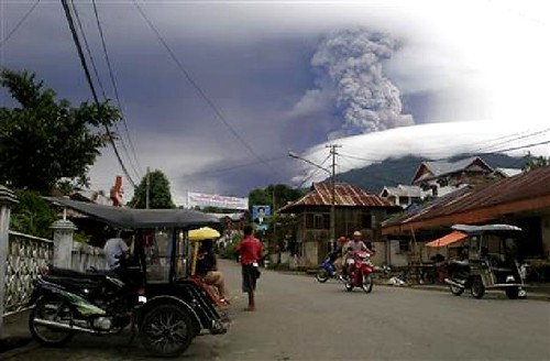
Mount Marapi’s towering presence commands awe with its rugged volcanic landscape and the raw power of its frequent eruptions. Approaching the volcano, one would witness a dramatic contrast between the lush rainforest on its lower slopes and the stark, extraterrestrial volcanic plateau near the summit. The air carries a palpable tension, a reminder of the mountain’s volatile nature. While the emotional draw to stand at the crater rim is strong, current safety concerns have led to a permanent ban on hiking, underscoring the respect this fiery giant demands.

The Volcano Itself: Geological Background
Mount Marapi is a stratovolcano located in West Sumatra, Indonesia, rising to 2,891 meters above sea level. It is one of the most active volcanoes on the island of Sumatra, with over 50 recorded eruptions in the last three centuries. The volcano formed through successive layers of lava flows, ash, and volcanic debris, creating its classic conical shape. Its crater complex includes multiple peaks, with Puncak Merpati being the highest point in the crater area. The volcano’s eruptions have produced significant ash clouds and lava flows, shaping the surrounding landscape. Fumaroles and sulfur deposits are common near the crater, contributing to the mountain’s dynamic geology. The volcanic plateau near the summit offers unique terrain, including rocky outcrops and ash slopes, while the lower slopes are covered by dense rainforest. Mount Marapi’s geological activity is closely monitored due to its potential hazards to nearby communities.
The Volcano Trek: Terrain and Hiking Experience
Mount Marapi’s terrain is characterized by a diverse volcanic landscape that presents both challenges and unique experiences for trekkers. The lower slopes are cloaked in dense tropical rainforest, offering a humid and shaded environment with rich biodiversity. As hikers ascend, the vegetation thins, giving way to a stark volcanic plateau marked by loose volcanic ash, pumice, and rugged lava rock formations. The upper slopes include steep ash-covered inclines that can be slippery and unstable, requiring careful footing and good physical conditioning. Rocky outcrops and boulder fields add to the technical challenge, demanding agility and sure-footedness. The volcanic plateau near the summit is exposed to strong winds and rapid temperature changes, which can affect comfort and safety. Altitude gain is significant, rising from approximately 1,400 meters at the base to nearly 2,900 meters at the summit, which may cause mild altitude effects for some hikers. The trail conditions vary seasonally, with dry periods offering firmer footing, while rainy seasons can make the ash slopes treacherous and prone to erosion. Despite the mountain’s natural allure, the permanent hiking ban currently prohibits trekking activities due to the high volcanic activity and associated risks. Historically, hikers have been advised to start ascents at night or early morning to avoid daytime volcanic gas emissions and to reach the crater area by sunrise for spectacular views. However, safety concerns now override these experiences, and visitors are urged to respect the closure for their protection.
What Makes This Volcano Trek Unique
Mount Marapi stands out as one of Sumatra’s most active volcanoes, earning the local name “Mountain of Fire.” Its frequent eruptions and dynamic volcanic activity create a landscape that is both volatile and mesmerizing. The volcano’s proximity to the city of Bukittinggi allows for dramatic views of its smoking crater and the surrounding volcanic plateau. The presence of unique geological features such as fumaroles, sulfur deposits, and the expansive volcanic plateau near the summit adds to its allure. Cultural significance also enhances the trek’s uniqueness; local Minangkabau traditions regard Marapi as a spiritual landmark, with ancestral legends tied to its slopes. The mountain’s biodiversity, ranging from lush rainforest to barren volcanic terrain, offers a striking contrast rarely seen in other volcano treks. However, the permanent hiking ban underscores the volcano’s unpredictable nature, making it a rare example of a highly active volcano where public access is restricted for safety.
The Summit and Crater Experience
Reaching the summit of Mount Marapi historically offered hikers a breathtaking panorama of West Sumatra’s volcanic landscape. The crater area, often shrouded in mist and volcanic gases, presents a raw and powerful scene with steaming fumaroles and the distinct smell of sulfur permeating the air. The heat emanating from fumaroles and the occasional rumble of escaping gases remind visitors of the mountain’s restless nature. From the summit, views extend over the surrounding valleys, neighboring Singgalang volcano, and on clear days, a sea of clouds below. The crater rim’s rugged terrain demands caution, as edges can be unstable and volcanic activity unpredictable. While the summit experience is dramatic and sensory-rich, current safety restrictions prohibit access to this area to protect visitors from volcanic hazards.
Best Time to Trek This Volcano
Due to the permanent hiking ban on Mount Marapi, trekking is currently not permitted at any time of year. Historically, the best time to attempt the climb was during the dry season to avoid slippery ash slopes and heavy rains. Trekkers often started ascents at midnight or early morning to reach the crater by sunrise, minimizing exposure to volcanic gases that tend to increase during the day. Seasonal weather patterns, such as monsoon rains, could increase the risk of lahars and unstable terrain. Volcanic activity levels have been the primary determinant of access, with authorities maintaining a Level II alert status that restricts activities within a three-kilometer radius of the crater. Visitors and locals are advised to stay informed through official volcanic monitoring agencies and to heed all safety warnings.
Trekking Routes and Trail Options
Mount Marapi features several trekking routes historically used by hikers, though all are currently closed due to safety concerns. The most popular route began at the village of Koto Baru, ascending via Jalan Tantawi and passing a telecommunications mast at 1,320 meters before reaching the crater area. This trail was considered relatively straightforward but exposed, with limited shade and challenging ash slopes near the summit. Another, more demanding route starts from the village of Kacawali at 1,400 meters elevation, leading to the true summit known as Puncak Garuda or Marapi Tuo. This northern path is steep, with sections reaching 80-degree inclines, requiring at least eight hours to ascend and often an overnight stay. It passes through bamboo vegetation and features spectacular views of a 500-meter waterfall at 2,400 meters. This route is rarely attempted due to its difficulty and the risk of getting lost. The crater complex’s highest accessible peak is Puncak Merpati at 2,757 meters, favored by most hikers before the ban. All routes require careful navigation and local knowledge, with guides traditionally available in Bukittinggi. Currently, no trekking or guiding services operate on Mount Marapi due to the permanent closure.
Difficulty Assessment
Mount Marapi’s trekking difficulty was classified as moderate, with some routes presenting demanding sections. The ascent involves significant altitude gain from approximately 1,400 meters to nearly 2,900 meters, requiring good cardiovascular fitness. Terrain challenges include steep ash slopes, loose volcanic rock, and exposed ridges subject to strong winds. The northern route to the true summit is particularly strenuous, with steep inclines and technical scrambling. Altitude effects may affect some hikers, especially those unacclimated. While no technical climbing equipment was generally required, hikers needed to be prepared for variable weather and unstable footing. Given the volcano’s active status and unpredictable eruptions, the difficulty assessment must also consider volcanic hazards, which currently prohibit all trekking activities.
Essential Volcano Trekking Gear
For a safe and comfortable trek on Mount Marapi (when access was permitted), essential gear included sturdy hiking boots with good grip to navigate loose ash and rocky terrain. Trekking poles were recommended to aid balance on steep slopes. Due to volcanic gases and ash, a respirator or gas mask was advisable, especially near the crater. Layered clothing was necessary to adapt to temperature changes from warm lower slopes to cooler summit conditions. A windproof jacket protected against strong winds on exposed ridges. Headlamps were essential for night ascents aiming to reach the crater by sunrise. Hydration systems and sufficient water were critical, as shade was limited on upper slopes. Sun protection, including hats and sunscreen, was important due to intense sun exposure. Emergency supplies, such as first aid kits and communication devices, were also recommended given the volcano’s active nature.
Safety and Volcanic Hazards
Mount Marapi poses significant volcanic hazards that have led to a permanent hiking ban for public safety. The volcano is currently classified at Level II alert status, indicating moderate volcanic activity with potential for eruptions. Hazards include sudden explosive eruptions, ashfall, lava flows, and pyroclastic flows. Volcanic gases such as sulfur dioxide can cause respiratory issues, necessitating masks for protection. The crater edges are unstable and prone to collapse, while loose scree and ash slopes increase the risk of falls. Sudden weather changes can reduce visibility and increase hypothermia risk. Authorities maintain continuous monitoring through the West Sumatra Natural Resources Conservation Agency (BKSDA) and the Volcano Monitoring Post (PGA). The public is strictly prohibited from entering within three kilometers of the crater to avoid exposure to these dangers. Compliance with official warnings and restrictions is critical to prevent accidents and fatalities.
Permits, Guides, and Logistics
Mount Marapi is currently closed to all trekking activities due to its active volcanic status and associated safety risks. The West Sumatra Natural Resources Conservation Agency (BKSDA), in coordination with local governments and the Ombudsman, has imposed a permanent hiking ban within a three-kilometer radius of the crater. This ban aims to protect the public from volcanic hazards, including eruptions, ashfall, and lava flows. Previously, permits were required to enter the Mount Marapi Natural Tourism Park, with an online booking system implemented for trail access. Entrance fees included a Rp10,000 online booking ticket, Rp25,000 for travel service permits covering evacuation and trail management, and Rp2,500 for insurance. Visitors registered at trailheads in villages such as Batu Palano, Koto Baru, and Aie Angek. Local guides were available in Bukittinggi, offering knowledge of the terrain and safety procedures. However, since the ban, no official tour operators or guides conduct hikes on Mount Marapi. Authorities continue to monitor the volcano closely to enforce the closure and prevent unauthorized access. Visitors interested in volcanic trekking in Indonesia are advised to consider other active volcanoes with safer access and professional guiding services.
Where to Stay Near Mount Marapi
While Mount Marapi itself is closed to trekking, the surrounding region offers several accommodation options for visitors interested in exploring West Sumatra’s natural and cultural attractions. The nearby city of Bukittinggi serves as the primary base, featuring a range of hotels and guesthouses. Notable accommodations include boutique hotels in Bukittinggi’s old quarter, offering proximity to historical sites such as the Japanese WWII tunnels and the iconic Jam Gadang clock tower. For those seeking natural tranquility, lakeside hotels near Lake Maninjau provide serene settings surrounded by lush rice fields within a volcanic caldera. These lodgings offer amenities such as swimming pools, relaxation areas, and easy access to local cultural experiences. Padang city, approximately three hours’ drive from Mount Marapi, also offers boutique hotels with ocean views and modern comforts. While direct access to Mount Marapi’s trails is restricted, these nearby bases provide excellent opportunities to appreciate the region’s volcanic landscapes, engage with local culture, and plan alternative excursions to other volcanoes or geological sites in Sumatra.