
Mount Karkar Volcano Trekking Guide: Exploring Papua New Guinea’s Active Island Stratovolcano
Mount Karkar is an active andesitic stratovolcano located on Karkar Island in Papua New Guinea’s Madang Province. This comprehensive trekking guide covers the volcano’s geology, hiking terrain, routes, safety considerations, permits, and local accommodations, offering adventure travelers an expert resource for exploring this dramatic volcanic island.
Quick Volcano Snapshot
| Attribute | Value |
|---|---|
| Volcano type | Stratovolcano |
| Elevation | 1839 m |
| Location | Karkar Island, Madang Province, Papua New Guinea |
| Activity status | Active |
| Trekking difficulty | Moderate |
| Typical trek duration | 1-2 days |
| Altitude gain | Approximately 1200 m |
| Terrain type | Volcanic andesitic lava fields, ash slopes, tropical forest |
| Best season | Dry season (May to October) |
| Temperature range | 20°C to 30°C |
| Permit requirement | Local permits recommended; guided tours advised |
Introduction: The Experience of Hiking Mount Karkar
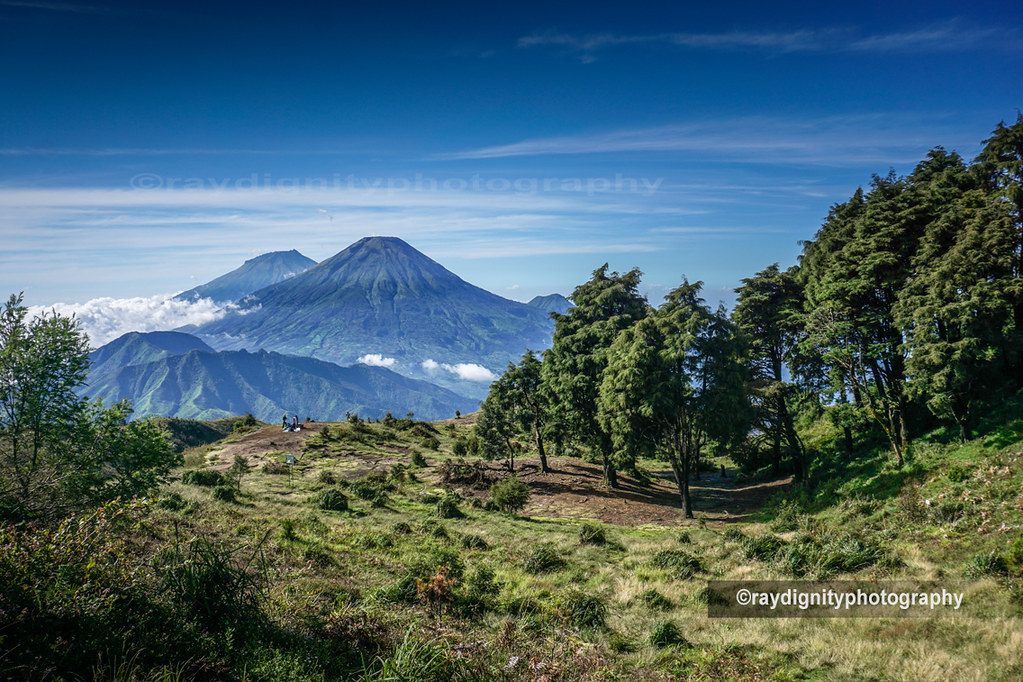
Approaching Mount Karkar, the island’s active stratovolcano rises dramatically above the lush tropical landscape, its twin calderas a testament to its fiery past. The trek immerses hikers in a landscape shaped by volcanic power — from fertile lava fields to dense jungle and ash-covered slopes. The contrast between the vibrant island life and the stark volcanic terrain creates a unique atmosphere of raw natural energy. Reaching the crater rim offers a profound sense of connection to the Earth’s inner forces, with panoramic views over the Bismarck Sea and the island’s patchwork of plantations and villages.
Geological Background of Mount Karkar
Mount Karkar is an andesitic stratovolcano located on Karkar Island, part of the Bismarck volcanic arc formed by the subduction of the Solomon Sea Plate beneath the Bismarck Plate. The volcano features two nested calderas: a large outer caldera approximately 5.5 km wide formed around 9,000 years ago, and a smaller inner caldera about 3.2 km in diameter with vertical walls up to 300 meters high, formed between 1,500 and 800 years ago. The active Bagiai cone within the inner caldera is the primary source of recent eruptions. Historical activity has included Strombolian and Vulcanian eruptions producing ash plumes and lava flows, with notable eruptions in the 1970s and as recently as 2013. The volcanic landscape is characterized by fresh andesitic lava flows, fumaroles, and sulfur deposits, contributing to the island’s fertile soils and diverse ecosystems.
The Volcano Trek: Terrain and Hiking Experience
Trekking Mount Karkar offers a diverse and engaging hiking experience shaped by the island’s volcanic origins and tropical climate. The trail typically begins at sea level near coastal villages, ascending through lush tropical plantations of cacao and coconuts. As hikers gain altitude, the terrain transitions to dense rainforest interspersed with volcanic ash and pumice deposits. The volcanic andesitic lava fields present rugged, uneven ground requiring careful footing, while ash slopes can be steep and loose, challenging balance and traction. Scrambling over jagged lava rocks is common near the summit, demanding moderate agility and sure-footedness. The trail also passes through areas of secondary forest recovering from past eruptions, with occasional fumarolic vents emitting steam and sulfurous gases. Altitude gain of approximately 1200 meters can cause mild effects for some trekkers, though the summit elevation of 1839 meters is generally manageable for those in good physical condition. Weather conditions vary; the tropical climate brings warm temperatures but also sudden rain showers and high humidity, which can make the trail slippery and increase the challenge. Wind near the crater rim can be strong, adding to the exposed feeling at the summit. The volcanic terrain’s mixture of soft ash, hard lava rock, and dense vegetation creates a dynamic hiking environment that rewards trekkers with spectacular views and a tangible sense of the island’s geological power. The trail’s moderate difficulty suits hikers with some experience and a reasonable fitness level, while local guides enhance safety and enrich the experience with cultural and natural insights.
What Makes the Mount Karkar Trek Unique
Mount Karkar’s trek stands out due to its location on a volcanic island surrounded by the Bismarck Sea, offering a rare combination of active volcanic landscapes and vibrant island culture. The presence of two nested calderas with vertical walls creates dramatic geological features rarely seen on island volcanoes. The fertile volcanic soils support lush plantations of cacao and coconuts, blending agriculture with wild nature. The active Bagiai cone’s ongoing fumarolic activity provides a living window into volcanic processes. Cultural encounters with local communities speaking Waskia and Takia languages enrich the journey, offering insights into traditional lifestyles shaped by the volcano. The island’s isolation and relatively low tourist numbers ensure a genuine, off-the-beaten-path adventure. The panoramic views from the summit encompass both the volcanic terrain and the surrounding ocean, creating a breathtaking contrast between fire and water.
The Summit and Crater Experience
Reaching the summit of Mount Karkar is a moment of awe and reflection. The crater rim, with its towering vertical walls, reveals the immense scale of past eruptions. From here, hikers witness the steaming fumaroles of the Bagiai cone, emitting white gas plumes that drift across the caldera floor. The air carries the sharp scent of sulfur, a reminder of the volcano’s restless nature. The ground beneath is warm in places, and the occasional hiss of escaping gases punctuates the silence. The panoramic vista stretches over the island’s patchwork of plantations, dense forests, and the vast expanse of the Bismarck Sea. On clear days, neighboring volcanic islands like Manam are visible, adding to the dramatic seascape. The summit experience combines sensory impressions of heat, smell, and sound with expansive views, creating a powerful connection to the Earth’s volcanic heartbeat.
Best Time to Trek Mount Karkar
The optimal trekking season for Mount Karkar is during Papua New Guinea’s dry months, typically from May to October. During this period, rainfall is reduced, trails are less slippery, and visibility from the summit is generally clearer. The tropical rainforest climate means heavy rain can occur year-round, but the dry season offers the most stable weather for hiking. Early morning starts are recommended to avoid afternoon showers and to experience cooler temperatures. Volcanic activity is monitored continuously; trekkers should check for any alerts or exclusion zones issued by the Rabaul Volcano Observatory before planning their trip. Avoiding the wet season also reduces the risk of trail erosion and difficult river crossings. Temperatures range from 20°C to 30°C, but can be cooler and windier near the summit, so layered clothing is advisable.
Trekking Routes and Trail Options on Mount Karkar
The primary trekking route to Mount Karkar’s summit begins at coastal villages accessible by boat or road from Madang. The trail ascends through tropical plantations, local villages, and dense rainforest before reaching the volcanic ash slopes and lava fields near the summit. The typical ascent covers approximately 12 to 15 kilometers round trip, with an elevation gain of about 1200 meters. Most trekkers complete the hike in one to two days, often camping near the crater rim or returning the same day. Guided tours are highly recommended due to the challenging terrain and the need for local knowledge of trail conditions and volcanic activity. Alternative routes include shorter hikes to secondary peaks such as Mount Kanagio and Mount Uluman, offering varied perspectives of the island’s volcanic landscape. Some itineraries combine the volcano trek with cultural village visits, snorkeling, and coastal exploration. Trail conditions vary from well-trodden dirt paths to rugged lava rock sections requiring careful navigation. Seasonal weather impacts trail accessibility, with some routes becoming slippery or overgrown during the wet season. Local guides from companies like New Guinea Natural Tours and Pero Pero Ltd provide tailored trekking experiences, including logistical support, cultural interpretation, and safety monitoring.
Difficulty Assessment of the Mount Karkar Trek
Mount Karkar’s trek is classified as a moderate volcano trek. The terrain includes steep ash slopes, uneven lava rock, and tropical forest paths that require a good level of fitness and sure-footedness. Altitude is moderate at 1839 meters, so altitude sickness is uncommon but possible for sensitive individuals. The hike demands endurance for sustained uphill walking and agility for scrambling over rocky sections. Weather conditions such as heat, humidity, and sudden rain showers add to the challenge. No technical climbing equipment is needed, but trekking poles and sturdy boots with good grip are essential. The trail is suitable for hikers with prior trekking experience and a reasonable fitness base. Guided tours enhance safety and provide support for less experienced trekkers.
Essential Volcano Trekking Gear for Mount Karkar
Key gear for trekking Mount Karkar includes sturdy hiking boots with excellent grip to handle volcanic rock and ash slopes. Trekking poles help maintain balance on loose terrain. Lightweight, breathable clothing with layers is recommended to adapt to changing temperatures and humidity. A windproof and waterproof jacket is essential for sudden tropical showers. Sun protection such as a wide-brimmed hat, sunglasses, and high SPF sunscreen is critical due to limited shade on volcanic slopes. A headlamp is useful for early starts or camping near the summit. Hydration systems or water bottles are necessary to stay well hydrated in the tropical climate. A gas mask or respirator is generally not required but may be useful during periods of increased volcanic gas emissions. Basic first aid supplies, insect repellent, and a map or GPS device complete the essential kit.
Safety and Volcanic Hazards on Mount Karkar
Mount Karkar is an active volcano with ongoing fumarolic activity and occasional ash emissions. Sudden ash explosions and gas releases can occur without warning, making crater rim access hazardous during periods of unrest. Volcanic gases such as sulfur dioxide can irritate the respiratory system; hikers with respiratory conditions should take precautions. The terrain includes unstable crater edges, loose scree, and jagged lava rocks, posing risks of falls and injuries. Weather can change rapidly, with heavy rain increasing the risk of slippery trails and flash floods. Monitoring by the Rabaul Volcano Observatory provides alerts on volcanic activity; trekkers should heed official warnings and avoid restricted zones. Local guides are essential for navigating safely and responding to hazards. Emergency evacuation options are limited due to the island’s remote location, so thorough preparation and communication plans are critical.
Permits, Guides, and Logistics for Mount Karkar Trekking
Trekking Mount Karkar requires coordination with local authorities and tour operators to secure necessary permits and ensure safety. While there is no formal national park permit system, local village councils regulate access to the volcano and expect visitors to obtain permission before hiking. Engaging a local guide is strongly recommended for navigation, cultural interpretation, and safety, especially given the active volcanic status and challenging terrain. Several reputable tour operators offer guided trekking packages to Mount Karkar, including New Guinea Natural Tours, Papua New Guinea Foot Print Tours Ltd, No Roads Expeditions, Flynn’s Tours, and Pero Pero Ltd. These companies provide comprehensive services including transport from Madang, accommodation arrangements, local guides, and logistical support. Costs vary depending on the length and inclusiveness of the tour but typically range from moderate to premium pricing reflecting the remote location and specialized nature of the trek. Access to Karkar Island is by boat or small aircraft from Madang, with boat trips taking approximately five hours across the Bismarck Sea. Accommodation options on the island include eco-friendly guest houses such as Pero Pero Eco-Guest House and Suma Guest House, which offer meals and cultural experiences. Visitors should plan for limited infrastructure, variable communication, and the need for self-sufficiency in supplies. Advance booking and coordination with tour operators are essential to ensure a smooth and safe trekking experience.
Where to Stay and Nearby Bases for Mount Karkar Trekking
Accommodation options on Karkar Island are limited but offer authentic and comfortable experiences close to the volcano trailheads. Pero Pero Eco-Guest House at Mangul village is a nationally owned and operated facility emphasizing sustainable tourism and cultural immersion. It features bamboo and sago palm bungalows with open designs that blend comfort with ecological awareness. Guests can enjoy home-cooked meals included in rates, participate in local activities such as bilum weaving, village tours, and guided hikes to the volcano and nearby peaks like Mount Kanagio. Suma Guest House, located in Karkar Village along the coast, provides tidy, well-maintained rooms with beach access and is known for its cleanliness and friendly atmosphere. Both guest houses are within reasonable distance of trail starting points, allowing early morning departures for summit attempts. Madang town on the mainland serves as the primary gateway to Karkar Island, offering a range of accommodations, transport services, and tour operator offices. Travelers typically stay in Madang before and after their island trek. The island’s single road encircles the coastline, facilitating access between villages, guest houses, and boat landing sites. Facilities on the island are basic; visitors should prepare for limited electricity, intermittent internet, and simple amenities. Staying with local guest houses provides cultural exchange opportunities and supports community-based tourism. Advance reservations are advised, especially during peak trekking seasons.