
Mount Ngauruhoe Volcano Trekking Guide: Exploring New Zealand’s Iconic Stratovolcano
Mount Ngauruhoe, New Zealand’s most active stratovolcano and famous as Mount Doom in The Lord of the Rings, offers a demanding and dramatic trekking experience within Tongariro National Park. This guide covers the volcano’s geology, trekking terrain, routes, safety, permits, and nearby accommodations for adventurous hikers.
Quick Volcano Snapshot
| Attribute | Value |
|---|---|
| Volcano type | Stratovolcano |
| Elevation | 2,291 meters (7,516 feet) |
| Location | Central North Island, New Zealand |
| Activity status | Active (last eruption 1977) |
| Trekking difficulty | Demanding |
| Typical trek duration | 7-9 hours (Tongariro Alpine Crossing), additional 2-4 hours to summit Ngauruhoe |
| Altitude gain | Approximately 1,100 meters (3,600 feet) |
| Terrain type | Volcanic ash slopes, loose scree, lava rock, crater rim |
| Best season | October to April |
| Temperature range | -5°C to 15°C (23°F to 59°F) depending on season and altitude |
| Permit requirement | No permit required for Tongariro Alpine Crossing; climbing Mount Ngauruhoe discouraged out of cultural respect |
Introduction: The Experience of Hiking Mount Ngauruhoe
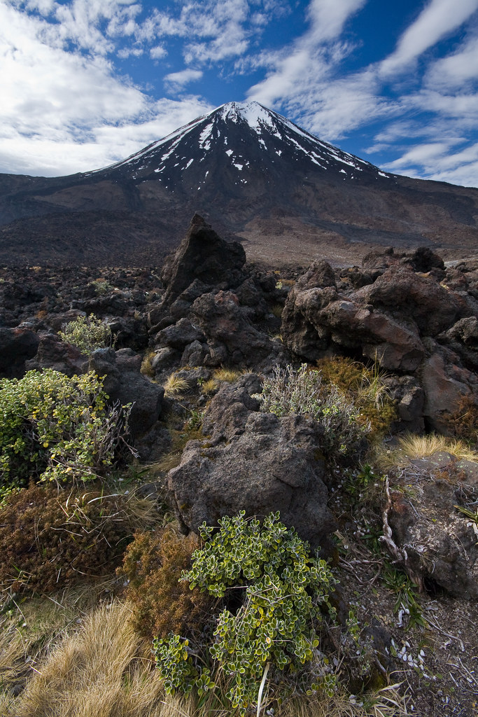
Approaching Mount Ngauruhoe, the iconic symmetrical cone rises sharply against the Central North Island skyline, evoking a sense of raw geological power. The volcanic landscape is stark and dramatic, with barren ash slopes contrasting against the vivid blue and emerald lakes nearby. Trekking here immerses you in a world shaped by fire and ice, where the silence is punctuated only by the crunch of volcanic gravel underfoot and the whisper of alpine winds. Reaching the base of the cone, the sheer scale and perfect form of the volcano inspire awe. Though climbing the summit is discouraged out of respect for Māori cultural values, the surrounding trails offer breathtaking views and a profound connection to New Zealand’s volcanic heart.
The Volcano Itself: Geological Background
Mount Ngauruhoe is a classic stratovolcano formed primarily of andesite lava, built up through repeated eruptions over the past 2,500 years. It is the youngest vent of the Tongariro volcanic complex and New Zealand’s most active volcano, having erupted more than 70 times since 1839, with the last eruption recorded in 1977. The volcano’s steep, symmetrical cone is composed of layers of hardened lava, ash, and volcanic rock. Its crater floor hosts fumaroles and steam vents, evidence of ongoing geothermal activity beneath the surface. The volcanic minerals deposited here create vivid colors in nearby lakes and soils. The mountain holds deep spiritual significance for the Māori people, who regard it as a sacred ancestor and a source of life-giving fire. This blend of geological dynamism and cultural reverence makes Mount Ngauruhoe a unique natural monument.
The Volcano Trek: Terrain and Hiking Experience
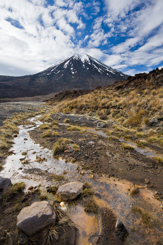
Trekking around Mount Ngauruhoe is a demanding adventure that challenges hikers with a variety of volcanic terrains. The primary approach is via the Tongariro Alpine Crossing, a 19.4-kilometer trail renowned for its dramatic landscapes and geological features. The trail traverses steep ash slopes, loose pumice scree, and rugged lava fields, requiring careful footing and good physical fitness. The ascent to the South Crater, adjacent to Ngauruhoe, involves navigating rocky ridges and exposed volcanic soil that erodes easily, so staying on marked paths is essential for safety and environmental protection. The terrain’s loose volcanic rock can be slippery, especially on descents, where hikers often resort to a cautious, crawling technique to maintain balance. Winds near the summit can be strong and chilling, and temperatures vary widely, demanding layered clothing and preparedness for sudden weather changes. The volcanic soil’s fragility means that trail erosion is a constant concern, and hikers must respect park regulations to minimize impact. Altitude effects are moderate but noticeable, with the summit reaching 2,291 meters, so acclimatization and hydration are important. The hike offers spectacular views of the Central Plateau, including the vivid Emerald and Blue Lakes formed in explosion craters. The contrast between the barren volcanic landscape and patches of native alpine vegetation adds to the trek’s visual richness. Overall, the terrain demands endurance, sure-footedness, and respect for the mountain’s natural and cultural significance.
What Makes This Volcano Trek Unique
Mount Ngauruhoe’s perfect conical shape and its role as the cinematic Mount Doom in The Lord of the Rings films give it a unique allure. The trek offers a rare opportunity to experience an active volcanic landscape within a dual World Heritage Site, combining geological wonder with cultural depth. The vivid colors of the Emerald and Blue Lakes, formed by volcanic minerals, create otherworldly scenes. The mountain’s ongoing geothermal activity, visible through fumaroles and steam vents, reminds hikers of the Earth’s restless energy. The cultural significance to the Māori people adds a profound layer of meaning, encouraging visitors to approach with respect and mindfulness. This blend of natural beauty, volcanic power, and cultural heritage makes trekking in the shadow of Mount Ngauruhoe a singular experience.
The Summit and Crater Experience
While climbing Mount Ngauruhoe’s summit is not officially prohibited, it is strongly discouraged out of respect for its sacred status to the Māori iwi. For those who do approach the base, the experience is striking: the crater rim reveals a rugged, steaming landscape with sharp volcanic rocks and fumaroles emitting sulfurous gases. The air carries a faint smell of sulfur, and the ground radiates residual heat. From the rim, panoramic views stretch across the Tongariro volcanic complex and the Central Plateau, offering a dramatic perspective of New Zealand’s volcanic heartland. The silence here is profound, broken only by the hiss of escaping gases and the occasional gust of wind. This moment connects hikers intimately with the primal forces that shaped the land.
Best Time to Trek Mount Ngauruhoe
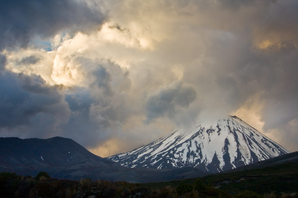
The optimal trekking season for Mount Ngauruhoe and the Tongariro Alpine Crossing is from October to April, when weather conditions are generally stable and snow-free. During these months, temperatures range from mild to cool, with daytime highs typically between 10°C and 15°C. Outside this window, winter conditions bring snow and ice, increasing the risk and requiring technical mountaineering skills and equipment. Weather in the alpine zone can change rapidly, so hikers should always check volcanic activity updates and weather forecasts before setting out. Volcanic monitoring is continuous, and access may be restricted during periods of increased activity. Sunrise climbs are popular for spectacular lighting but require headlamps and preparedness for cold temperatures. Avoiding the peak summer holidays can help reduce crowding on the trail.
Trekking Routes and Trail Options
The primary route to experience Mount Ngauruhoe is the Tongariro Alpine Crossing, a 19.4-kilometer one-way trail starting at the Mangatepopo car park and ending at the Ketetahi car park. This route passes close to the South Crater, offering views of Ngauruhoe’s imposing cone. The crossing typically takes 7 to 9 hours and is considered one of New Zealand’s best day hikes. While the official track does not include summiting Ngauruhoe, some hikers add an additional 3 kilometers and 2 to 4 hours to climb the volcano’s slopes, though this is discouraged for cultural reasons. The Tongariro Northern Circuit is a multi-day 41-kilometer loop that circumnavigates Ngauruhoe, incorporating the Alpine Crossing and offering a more extended exploration of the volcanic landscape with overnight stays in DOC huts. Guided tours are available for both routes, providing expert knowledge and logistical support. Shuttle services operate between trailheads to facilitate one-way hikes. Alternative shorter walks around the base and foothills of Ngauruhoe provide less strenuous options for those seeking volcanic views without the full crossing.

Difficulty Assessment
Mount Ngauruhoe’s trek is classified as demanding due to steep ascents, loose volcanic scree, and exposure to alpine weather. The Tongariro Alpine Crossing requires a good level of fitness, endurance, and sure-footedness. Altitude is moderate but can affect some hikers. The terrain includes steep ash slopes and rocky sections that challenge balance and stability. Technical climbing skills are not required for the official crossing, but the additional summit climb involves scrambling over sharp volcanic rocks and is recommended only for experienced hikers. Weather conditions can add difficulty, with strong winds and sudden temperature drops common. Overall, the trek suits well-prepared and physically fit hikers comfortable with rugged mountain environments.
Essential Volcano Trekking Gear
Key gear for trekking Mount Ngauruhoe includes sturdy hiking boots with excellent grip to handle loose volcanic scree and sharp rocks. Trekking poles help maintain balance on steep and unstable terrain. Layered clothing is essential to adapt to temperature changes and alpine winds, including a windproof and waterproof jacket. A headlamp is recommended for early starts or late finishes. Sun protection is critical due to high UV exposure and lack of shade—bring sunscreen, sunglasses, and a wide-brimmed hat. Carry sufficient water and high-energy snacks, as there are no facilities on the trail. A map and compass or GPS device aid navigation, though the trail is well-marked. Gas masks or respirators are generally not required but may be useful if volcanic gases are present. First aid supplies and emergency communication devices are advisable for safety.
Safety and Volcanic Hazards
Mount Ngauruhoe is an active volcano, and hikers must be aware of volcanic hazards including sudden eruptions, toxic gases, and unstable terrain. The Department of Conservation and GeoNet continuously monitor volcanic activity and issue warnings or closures as needed. During periods of unrest, access to the crater and upper slopes may be restricted. Volcanic gases such as sulfur dioxide can cause respiratory irritation; hikers with asthma or other respiratory conditions should take precautions. The terrain features loose scree and sharp volcanic rocks, increasing the risk of slips and falls. Crater edges can be unstable, and falling rocks are a hazard, especially on steep slopes. Weather can change rapidly, bringing cold temperatures, strong winds, and reduced visibility. Hikers should always check current volcanic status and weather forecasts before starting, stay on marked trails, and carry appropriate safety equipment. Emergency services are available but response times can be delayed in remote alpine areas.
Permits, Guides, and Logistics
No formal permit is required to hike the Tongariro Alpine Crossing or to access the trails around Mount Ngauruhoe. However, climbing to the summit of Mount Ngauruhoe is strongly discouraged by the New Zealand Department of Conservation (DOC) out of respect for the mountain’s cultural significance to the Māori people. Visitors are asked to honor this request and avoid summit attempts. The Tongariro Alpine Crossing is a popular and well-managed trail with clear regulations: stay on marked tracks, carry out all rubbish, and respect sacred sites such as the Emerald and Blue Lakes. Several tour operators offer guided hikes and shuttle services to facilitate logistics. Notable operators include Across New Zealand Adventure Tours, Tongariro Guided Walks, and Tongariro Alpine Shuttles. These companies provide transport from nearby towns such as National Park Village, Turangi, and Taupo to trailheads, as well as guided experiences that include safety briefings and cultural insights. Shuttle services are recommended to avoid parking limitations at trailheads, especially during peak season from October to April. Hikers should book shuttles and guided tours well in advance during these months. Safety briefings and volcanic activity updates are provided by DOC and GeoNet, and hikers should check these before departure. The trail is free to access, but DOC huts on the Tongariro Northern Circuit require bookings and fees. Adequate preparation, including weather checks and equipment, is essential for a safe trek.
Where to Stay Near Mount Ngauruhoe
Accommodation options near Mount Ngauruhoe are centered around Tongariro National Park’s villages and nearby towns, providing convenient access to trailheads. Whakapapa Village, located at the base of Mount Ruapehu, offers a range of lodges, hostels, and hotels such as the Chateau Tongariro Hotel, a historic alpine-style hotel with stunning views of the volcanic peaks. National Park Village is another popular base with budget-friendly hostels, motels, and lodges that cater to hikers and skiers. Facilities here include communal kitchens, gear rental shops, and shuttle services to the Tongariro Alpine Crossing trailheads. Ohakune, approximately 30 minutes’ drive from the park, is a larger town with diverse accommodation options including boutique hotels, holiday parks, and bed-and-breakfasts. It also offers restaurants, cafes, and outdoor gear stores. For those seeking a more rustic experience, Department of Conservation huts along the Tongariro Northern Circuit provide basic shelter with bunks, heating, and cooking facilities, but require advance booking. Camping is permitted in designated areas but not on the Alpine Crossing itself. Many visitors choose campervans or holiday parks in the region for flexible stays. Overall, the accommodation network supports a range of budgets and preferences, all within easy reach of Mount Ngauruhoe’s volcanic trails.