
Mount Muhabura Volcano Trekking Guide: Conquer the Virunga’s Majestic Stratovolcano
Mount Muhabura, a dormant stratovolcano standing at 4,127 meters on the Rwanda-Uganda border, offers a challenging yet rewarding volcano trek. This guide covers its geology, trekking terrain, routes, permits, safety, and accommodation options near Volcanoes National Park.
Quick Volcano Snapshot
| Attribute | Value |
|---|---|
| Volcano type | Stratovolcano |
| Elevation | 4,127 meters (13,540 feet) |
| Location | Virunga Mountains, border of Rwanda and Uganda |
| Activity status | Dormant |
| Trekking difficulty | Moderate to challenging |
| Typical trek duration | 8-10 hours round trip |
| Altitude gain | Approximately 1,600 meters |
| Terrain type | Steep bamboo forests, hagenia woodlands, alpine moorlands, rocky summit |
| Best season | June to September, December to February |
| Temperature range | 5°C to 20°C depending on altitude and season |
| Permit requirement | Required, $75-$100 USD depending on side |
Introduction: The Experience of Hiking Mount Muhabura
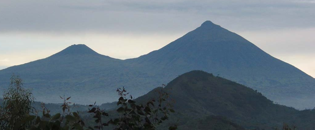
Approaching Mount Muhabura, the towering stratovolcano dominates the horizon, its perfect cone rising sharply above the lush Virunga landscape. The trek immerses hikers in a dramatic geological setting where dense bamboo forests give way to open moorlands and rocky alpine zones. The air thins as you ascend, heightening the sense of challenge and adventure. Reaching the summit crater lake, surrounded by a rim offering 360-degree views across Rwanda, Uganda, and the Democratic Republic of Congo, is a profound moment of connection with the Earth’s volcanic power and the region’s natural beauty.
Geological Background of Mount Muhabura
Mount Muhabura is a dormant stratovolcano forming part of the Virunga Mountain chain, which spans Rwanda, Uganda, and the Democratic Republic of Congo. Rising to 4,127 meters, it is the third highest volcano in the range. The mountain’s classic conical shape is the result of successive lava flows and ash deposits from eruptions during the Holocene period, although its last eruption date remains uncertain. The summit features a small crater lake approximately 40 meters wide, a rare feature among the Virunga volcanoes. The volcano’s slopes are covered with volcanic ash and rock, supporting diverse vegetation zones from bamboo forests to alpine moorlands. Fumaroles and sulfur deposits are limited, reflecting its dormant status. The mountain’s geological history is intertwined with the tectonic activity of the East African Rift, which has shaped the region’s dramatic volcanic landscape.
The Volcano Trek: Terrain and Hiking Experience
Hiking Mount Muhabura is a physically demanding but immensely rewarding experience. The trek begins at approximately 2,500 meters elevation, ascending steeply through cultivated fields before entering dense bamboo forests. This bamboo zone is often muddy and slippery, requiring careful footing and sometimes the use of bamboo stems for balance on the steepest sections. As you climb, the trail transitions into hagenia and hypericum woodlands, where the forest opens slightly, offering glimpses of neighboring volcanoes and the surrounding landscape. The terrain here remains steep, with narrow paths that challenge endurance.
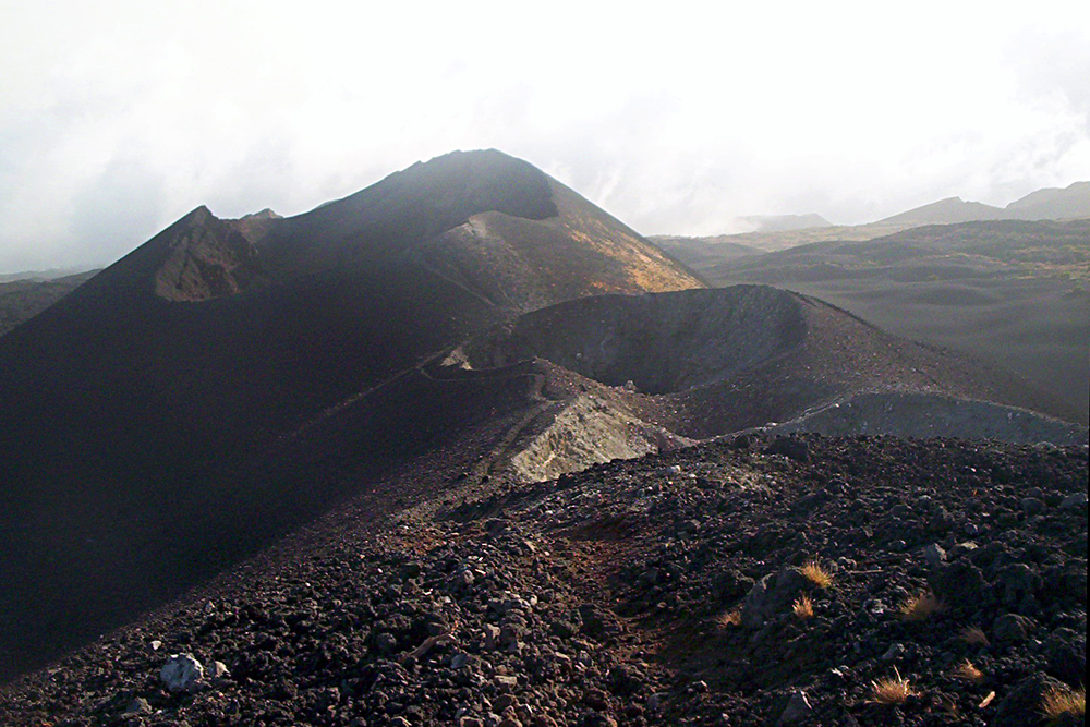
Above the treeline, the environment shifts dramatically to alpine moorlands dotted with giant senecio and lobelia plants. The vegetation thins, and the trail becomes rockier and more exposed to wind and weather. The final ascent involves scrambling over volcanic rocks and loose scree, demanding sure-footedness and stamina. Altitude effects become noticeable near the summit, with thinner air and cooler temperatures. The summit crater lake is surrounded by a rim that requires careful navigation due to loose volcanic material and steep drops.
Throughout the hike, trekkers encounter diverse terrain types, from soft volcanic ash to rugged lava rock, each affecting pace and difficulty. Weather can change rapidly, with sudden rain making the trail slippery. The combination of steep slopes, altitude gain of approximately 1,600 meters, and variable trail conditions classifies this trek as moderate to challenging. Porters are available to assist with heavy loads, which is recommended for less experienced hikers. Overall, the terrain offers a dynamic and immersive volcanic hiking experience, blending natural beauty with physical challenge.
What Makes the Mount Muhabura Trek Unique
Mount Muhabura stands out among the Virunga volcanoes for its perfect conical shape and the rare presence of a summit crater lake. The hike offers unparalleled panoramic views of the entire Virunga range, including neighboring volcanoes like Karisimbi, Bisoke, and Sabyinyo, as well as Rwanda’s terraced hillsides, Uganda’s lush landscapes, and the distant Nyiragongo crater in the Democratic Republic of Congo. The summit’s position on the Rwanda-Uganda border allows hikers to stand in two countries simultaneously, a unique and memorable photo opportunity.
The trek traverses diverse ecological zones, from dense bamboo forests inhabited by golden monkeys to open alpine moorlands with giant groundsels and lobelias. Wildlife sightings, including various bird species and occasional forest mammals, enrich the experience. Unlike more crowded Virunga treks, Mount Muhabura offers a quieter, more solitary adventure, appealing to hikers seeking both challenge and tranquility. The combination of geological features, biodiversity, and cultural significance as “the guide” mountain makes this trek a distinctive and compelling journey.
Summit and Crater Experience
Reaching the summit of Mount Muhabura is a moment of awe and accomplishment. The small crater lake at the peak, about 40 meters wide, reflects the sky amidst the rugged volcanic rim. The air is crisp and cool, carrying faint scents of damp earth and volcanic minerals. From this vantage point, hikers are rewarded with sweeping 360-degree views that stretch across three countries. The twin lakes of Ruhondo and Burera shimmer below, framed by rolling hills and distant volcanoes.
The summit’s rocky terrain demands careful steps, but the panoramic vistas make every effort worthwhile. The silence at the top is profound, broken only by the wind and occasional bird calls. The crater lake’s serene surface contrasts with the mountain’s steep, challenging slopes, offering a peaceful spot to rest and reflect. On clear days, the view extends to the Rwenzori Mountains and Lake Edward, connecting hikers to the vast geological and ecological tapestry of the region.
Best Time to Trek Mount Muhabura
The optimal periods for trekking Mount Muhabura are during the dry seasons from June to September and December to February. During these months, trails are less muddy and more stable, reducing the risk of slips and making the ascent more manageable. Weather conditions are generally clearer, enhancing visibility for the spectacular summit panoramas.
The rainy seasons bring frequent showers that can turn paths slippery and challenging, especially in the bamboo and forest zones. Sudden weather changes are common, so hikers should be prepared for rain and cooler temperatures at higher elevations year-round. Volcanic activity is dormant, so there are no eruption-related restrictions, but hikers should always check local park advisories before planning their trip.
Early morning starts are recommended to avoid afternoon rains and to enjoy the sunrise views from the summit. Trekking during the dry seasons also aligns with the availability of guides and permits, which are easier to secure when demand is lower.
Trekking Routes and Trail Options on Mount Muhabura
Mount Muhabura can be ascended from either the Rwandan or Ugandan side, each offering distinct logistical and trail experiences.
From Rwanda, the trek starts at the Volcanoes National Park headquarters in Kinigi. After registration and briefing, hikers are transferred to the trailhead near the Uganda border. The route covers approximately 12 kilometers round trip, with an elevation gain of about 1,600 meters. The trail passes through cultivated fields, dense bamboo forests, hagenia woodlands, and alpine moorlands before reaching the summit crater lake. This route is well-marked and supported by Rwanda Development Board rangers. Porters can be hired for $15-$20 to assist with gear.
From Uganda, the ascent begins at Mgahinga Gorilla National Park headquarters in Ntebeko, Kisoro District. Hikers register and receive a briefing before starting the climb. The Ugandan trail is steeper and more direct, traversing montane forest, bamboo zones, and alpine vegetation. Ranger guides from the Uganda Wildlife Authority accompany trekkers for safety and interpretation. The trail length and elevation gain are similar to the Rwandan side, with a typical round trip duration of 8-10 hours.
Both routes require a permit, costing approximately $75-$100 USD, depending on the country of entry. Guided hikes are mandatory for safety and conservation reasons. The choice of route may depend on travel logistics, permit availability, and personal preference. Some trekkers combine the hike with gorilla or golden monkey trekking in the respective parks, enhancing the overall adventure.
Difficulty Assessment of Mount Muhabura Trek
Mount Muhabura is classified as a moderate to challenging volcano trek. The steep slopes, altitude gain of roughly 1,600 meters, and variable terrain demand good physical fitness and stamina. The trail includes slippery bamboo forests, rocky alpine sections, and loose volcanic scree near the summit, requiring sure-footedness and careful pacing.
Altitude effects become noticeable above 3,000 meters, with thinner air and cooler temperatures that can affect breathing and endurance. The hike typically takes 8 to 10 hours round trip, making it a full-day commitment. While technical climbing skills are not required, hikers should be prepared for sustained uphill walking and variable weather conditions.
Beginners with reasonable fitness can attempt the trek with adequate preparation and the assistance of porters. Experienced hikers will find the challenge rewarding, especially given the spectacular summit views and diverse ecological zones. Overall, the trek is more demanding than some neighboring Virunga volcanoes but accessible to well-prepared adventure travelers.
Essential Gear for Trekking Mount Muhabura
Proper gear is crucial for a safe and comfortable hike on Mount Muhabura. Recommended items include sturdy hiking boots with good grip to navigate slippery and rocky terrain. Trekking poles help maintain balance on steep and uneven paths. Layered clothing is essential to adapt to temperature changes, including moisture-wicking base layers, insulating mid-layers, and a waterproof, windproof jacket.
A hat and gloves protect against cold winds near the summit. Carry a headlamp for early starts or late finishes. Ample water and high-energy snacks are necessary to maintain hydration and energy levels during the long ascent. A small first aid kit, sunscreen, and insect repellent are also advisable.
Given the volcanic environment, gaiters can prevent ash and debris from entering boots. While volcanic gases are minimal due to dormancy, sensitive individuals may consider a lightweight respirator. A camera is recommended to capture the stunning landscapes. Finally, a daypack to carry essentials comfortably completes the gear list.
Safety and Volcanic Hazards on Mount Muhabura
Mount Muhabura is a dormant volcano with no recent eruptions, minimizing volcanic hazards. However, trekkers should remain vigilant about natural risks associated with high-altitude volcanic terrain. Steep and unstable slopes can cause slips and falls, especially on loose scree and wet bamboo forest trails. Sudden weather changes, including rain and strong winds, increase the risk of hypothermia and accidents.
While volcanic gases are not a significant threat, hikers should avoid lingering near fumaroles or sulfur vents if encountered. Rangers and guides monitor trail conditions and provide safety briefings. It is essential to follow their instructions and stay on marked paths to prevent accidents and protect fragile ecosystems.
Emergency response infrastructure is limited; therefore, adequate preparation, physical fitness, and hiring experienced guides are critical for safety. Visitors should inform park authorities of their plans and expected return times. Carrying a communication device and first aid supplies is recommended. Overall, respecting the mountain’s natural conditions and adhering to safety protocols ensures a secure trekking experience.
Permits, Guides, and Logistics for Mount Muhabura Trekking
Trekking Mount Muhabura requires obtaining a permit from the relevant park authorities. In Rwanda, permits are issued by the Rwanda Development Board at the Volcanoes National Park headquarters in Kinigi. On the Ugandan side, permits are managed by the Uganda Wildlife Authority at Mgahinga Gorilla National Park headquarters in Ntebeko, Kisoro District. Permit costs range from $75 to $100 USD per person, depending on the country and season. Permits can often be secured on the day of the hike but booking in advance is recommended during peak seasons.
Guided hikes are mandatory for safety and conservation. Both Rwanda and Uganda provide trained ranger guides who accompany trekkers throughout the ascent. Guides offer valuable insights into the volcano’s geology, ecology, and cultural significance. Hiring porters is optional but highly recommended, especially for carrying heavy gear. Porter fees typically range from $15 to $20 USD.
Several reputable tour operators facilitate Mount Muhabura treks, including Unique Rwanda Vacations, Take Your Backpack, Uganda Gorilla Safaris Adventure, and Kenlink Tours. These operators assist with permit arrangements, transport logistics, and guide services, providing a seamless trekking experience.
Logistically, the trek starts early, around 7:00 AM, to allow sufficient time for the 8-10 hour round trip. Transport to trailheads is available from Kigali (Rwanda) or Kisoro (Uganda), with drives lasting approximately 2 hours. Public transport options exist but private transfers are more convenient. Trekkers should bring packed lunches, sufficient water, and appropriate gear. Accommodation can be arranged near trailheads for early starts.
Overall, careful planning of permits, guides, and transport ensures a safe and enjoyable Mount Muhabura trekking adventure.
Where to Stay and Nearby Bases for Mount Muhabura Treks
Accommodation options near Mount Muhabura cater to a range of budgets and preferences, primarily located in Rwanda’s Musanze town and Uganda’s Kisoro district.
In Rwanda, the Muhabura Hotel in Musanze is a popular budget-friendly choice. Situated about 13.5 kilometers from Volcanoes National Park headquarters, it offers over 30 rooms and 6 apartments with amenities such as hot showers, flushing toilets, Wi-Fi, a restaurant, bar, sauna, and massage services. The hotel is historically significant as the late Dian Fossey stayed here during her gorilla research. Rooms range from $50 to $90 per night, with the famous Room 12 available for a premium. The hotel’s central location provides easy access to the park, local markets, and other attractions.
In Uganda, Kisoro Tourist Hotel and Ntebeko Homestay near Mgahinga Gorilla National Park serve as convenient bases. Kisoro Tourist Hotel offers comfortable rooms with private bathrooms, a restaurant, bar, and tour arrangement services. Ntebeko Homestay provides a more intimate setting with spacious, clean rooms and free parking.
Travellers Rest Hotel near Kisoro is another option, featuring affordable rooms and proximity to park offices. These accommodations provide essential services such as meals, laundry, and transport arrangements.
For trekkers seeking eco-lodges or campsites, options exist within the parks but require advance booking and may have limited facilities. Many hikers prefer to stay in Musanze or Kisoro for comfort and access to guides and permits.
Overall, these accommodations offer restful environments to prepare for or recover from the strenuous Mount Muhabura trek, with easy access to trailheads and local amenities.