
Mount Malinao Volcano Trekking Guide: Exploring the Bicol Region’s Volcanic Giant
Mount Malinao is a potentially active stratovolcano in the Bicol Region of the Philippines, offering a challenging moderate trek through volcanic landscapes, lush forests, and panoramic views. This guide covers its geology, trekking routes, safety tips, permits, accommodations, and more.
Quick Volcano Snapshot
| Attribute | Value |
|---|---|
| Volcano type | Stratovolcano |
| Elevation | 1,657 meters (5,436 feet) |
| Location | Bicol Region, Philippines |
| Activity status | Potentially active |
| Trekking difficulty | Moderate |
| Typical trek duration | 5-6 hours to summit |
| Altitude gain | Approximately 1,200 meters |
| Terrain type | Steep rocky trails, volcanic ash slopes, forested areas |
| Best season | Dry season (November to May) |
| Temperature range | 15°C to 30°C (59°F to 86°F) |
| Permit requirement | Required; local permits and guides recommended |
Introduction: The Experience of Hiking Mount Malinao
Approaching Mount Malinao, hikers are greeted by a towering stratovolcano cloaked in lush greenery and volcanic rock. The trail winds through dense forests and agricultural lands, revealing the raw power of the earth beneath. As you ascend, the landscape shifts to rugged volcanic terrain, with steep slopes and rocky outcrops. The air carries the faint scent of sulfur from fumaroles, a reminder of the volcano’s latent energy. Reaching the crater rim, the panorama unfolds with views of the neighboring Mayon Volcano and the Albay Gulf, a breathtaking reward for the challenging climb. The contrast between fertile farmland and barren volcanic slopes creates a dramatic setting that captivates every adventurer.
The Volcano Itself: Geological Background
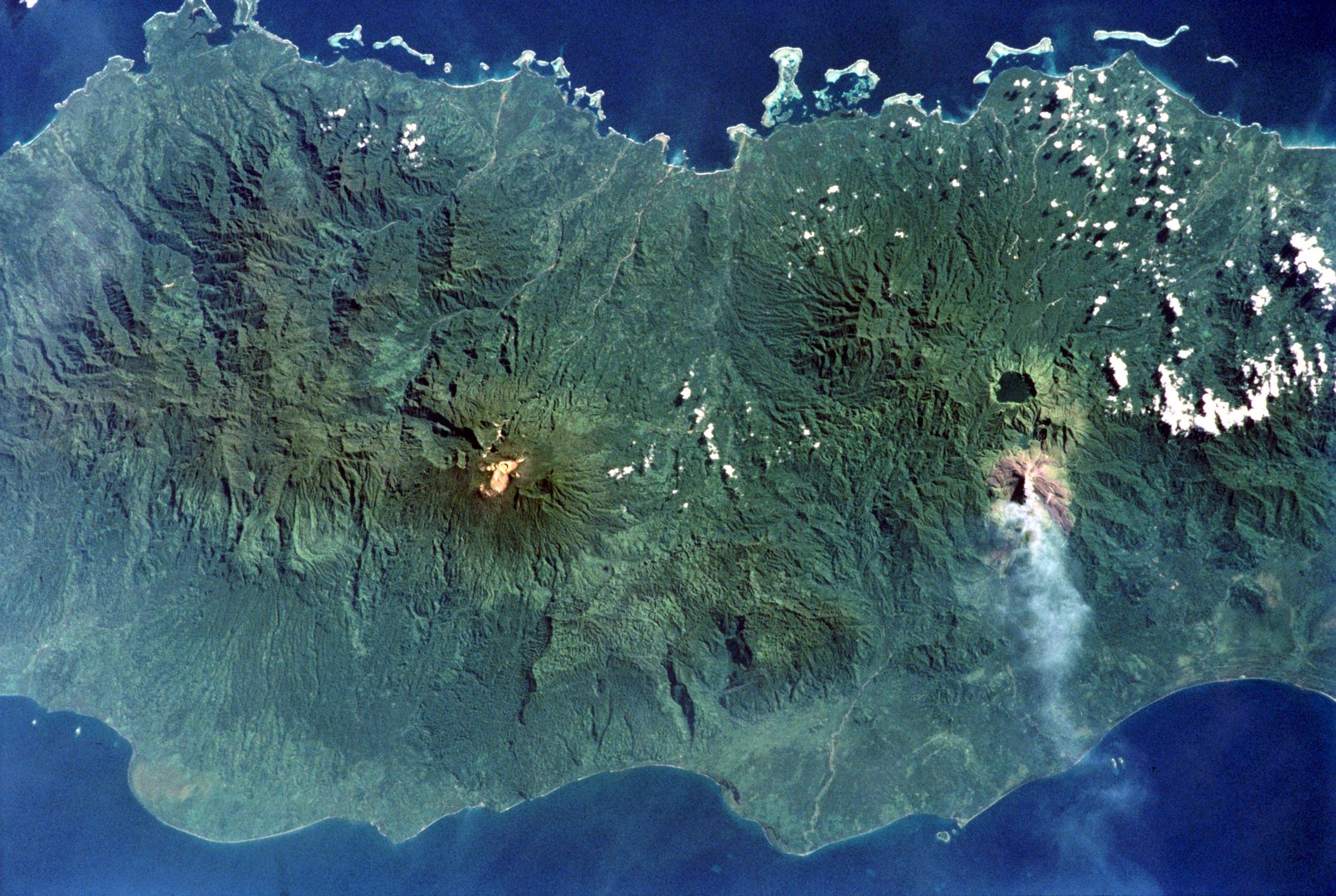
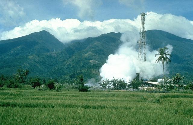
Mount Malinao is a stratovolcano located in the Bicol Region of the Philippines, part of the Pacific Ring of Fire known for intense volcanic and seismic activity. It rises to 1,657 meters and features a large crater with breached eastern walls. The volcano formed through successive eruptions of andesitic lava flows and pyroclastic deposits over hundreds of thousands of years. Although there are no recorded historical eruptions, Malinao is classified as potentially active due to ongoing fumarolic activity and seismic swarms observed in the 20th century. The volcano’s slopes host Luzon’s largest solfataras and hot springs, with temperatures reaching up to 108°C in fumaroles. These geothermal features have been harnessed for electricity generation at the Tiwi Geothermal Power Plant on its flank. The volcanic minerals and siliceous sinter deposits around the hot springs highlight the dynamic geological processes shaping this landscape.
The Volcano Trek: Terrain and Hiking Experience
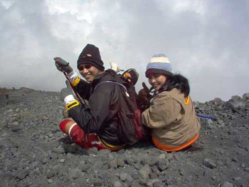
Trekking Mount Malinao offers a diverse and immersive hiking experience through volcanic landscapes and tropical forests. The trail begins near the Mayon Volcano National Park, winding through agricultural fields where local farmers cultivate rice, corn, and coconut. Early sections feature rocky paths interspersed with abaca plantations, providing a glimpse into the region’s rural life. As the ascent progresses, the terrain becomes steeper and more challenging, with loose volcanic ash and pumice underfoot demanding careful footing. Hikers encounter river crossings and narrow ridges that test balance and endurance. The volcanic soil supports lush vegetation, including moss-covered trees and vibrant wildflowers, contrasting with the stark, barren crater rim. Wind conditions intensify near the summit, and temperature can drop significantly, especially during early morning climbs. Altitude effects are mild but noticeable, requiring moderate fitness levels. Water sources are available along the trail, but carrying sufficient hydration is essential. The trail’s ruggedness and changing terrain make the trek moderately difficult, rewarding hikers with spectacular views of the Mayon Volcano, Albay Gulf, and surrounding mountain ranges. The combination of geological features, forest ecosystems, and panoramic vistas creates a rich and varied trekking experience unique to Mount Malinao.
What Makes This Volcano Trek Unique
Mount Malinao stands out for its combination of active geothermal features and lush tropical surroundings. Unlike many volcanoes with barren slopes, Malinao’s forested flanks offer a vibrant ecosystem thriving on volcanic soil. The presence of Luzon’s largest solfataras and hot springs near the Tiwi geothermal area adds a rare geothermal dimension to the trek. Hikers can witness steaming fumaroles and mineral deposits that tell the story of the volcano’s subterranean activity. The proximity to the iconic Mayon Volcano provides dramatic vistas of its perfect cone, enhancing the visual appeal. Additionally, the cultural landscape surrounding Malinao, with agricultural communities and traditional farming practices, enriches the trekking experience with local heritage. The trail’s moderate difficulty and relatively unspoiled nature make it an off-the-beaten-path adventure for volcano enthusiasts seeking both geological intrigue and natural beauty.
The Summit and Crater Experience
Reaching the summit of Mount Malinao, trekkers are greeted by a vast crater with steep, bare inner walls breached on the eastern side. The crater rim offers sweeping panoramic views of the Bicol landscape, including the majestic Mayon Volcano and the shimmering Albay Gulf. The air is tinged with the faint sulfurous aroma from active fumaroles, and the ground beneath may feel warm in places. The summit’s exposed position subjects visitors to strong winds and cooler temperatures, creating a stark contrast to the humid forested ascent. The silence at the top is profound, broken only by the occasional hiss of escaping gases. This sensory experience—combining sight, smell, and sound—immerses hikers in the raw power of the volcano. The crater’s geological features, including mineral deposits and fumarolic vents, provide a tangible connection to the earth’s inner forces, making the summit a memorable highlight of the trek.
Best Time to Trek Mount Malinao
The ideal time to trek Mount Malinao is during the dry season, from November to May, when trails are less slippery and weather conditions are more stable. Early morning starts are recommended to avoid midday heat and to enjoy clearer views of the surrounding volcanoes and landscapes. The wet season, typically from June to October, brings heavy rains that can make the steep volcanic slopes treacherous and increase the risk of landslides. Additionally, volcanic gas emissions are generally low during the dry months, reducing health risks. It is important to check with local authorities or guides for any volcanic activity alerts or trail closures before planning your trek. Seasonal variations in temperature mean that nights and early mornings can be cool, so appropriate clothing is advised. Planning your hike around these conditions ensures a safer and more enjoyable experience.
Trekking Routes and Trail Options
The primary trekking route to Mount Malinao’s summit begins near the Mayon Volcano National Park, close to the town of Gabas. This trail is the most established and commonly used by hikers. It covers approximately 8 to 10 kilometers one way, with an elevation gain of around 1,200 meters, typically taking 5 to 6 hours to reach the summit. The trail passes through agricultural lands, abaca plantations, and dense forest before ascending steep volcanic slopes. Along the way, hikers cross several small rivers and streams, with water sources available for refilling. There is a designated campsite roughly halfway up the mountain, providing an option for an overnight stay. Guided treks are highly recommended due to the challenging terrain and to support local communities. Local guides from Mountain Joiners and other Albay-based operators offer services including GPS waypoints, safety briefings, and cultural insights. Alternative routes are less developed and not recommended for inexperienced trekkers. The main trail’s combination of natural beauty, geological features, and manageable difficulty makes it the preferred choice for most visitors.
Difficulty Assessment
Mount Malinao is classified as a moderate volcano trek. The trail involves steep ascents on rocky and loose volcanic ash terrain, requiring good physical fitness and sure-footedness. While technical climbing skills are not necessary, hikers should be prepared for sustained uphill hiking, river crossings, and variable trail conditions. Altitude is moderate at 1,657 meters, so altitude sickness is uncommon but possible for sensitive individuals. The trail’s exposure near the summit to wind and cooler temperatures demands appropriate clothing and gear. Overall, the trek suits hikers with some prior mountain experience and a reasonable level of endurance. Beginners should consider hiring a guide and preparing adequately for the terrain and weather conditions.
Essential Volcano Trekking Gear
For a safe and comfortable trek up Mount Malinao, essential gear includes sturdy hiking boots with good grip to handle rocky and loose volcanic terrain. Trekking poles are recommended to aid balance and reduce strain on knees during steep ascents and descents. Carry sufficient water and high-energy snacks to stay hydrated and fueled. Sun protection such as sunscreen, a wide-brimmed hat, and sunglasses are vital due to limited shade on exposed slopes. A lightweight windproof jacket is necessary for summit conditions where winds can be strong and temperatures cooler. A headlamp or flashlight is useful for early morning or late afternoon hikes. A basic first aid kit should be included for minor injuries. Due to fumarolic activity, a dust mask or respirator can be helpful for sensitive individuals to filter volcanic gases and ash. Finally, a camera is recommended to capture the stunning volcanic landscapes and panoramic views.
Safety and Volcanic Hazards
While Mount Malinao is classified as potentially active, it has not erupted in recorded history, reducing immediate eruption risk. However, hikers should be aware of volcanic hazards such as fumarolic gases, which can be harmful in high concentrations. The trail’s steep and rocky terrain presents risks of slips, falls, and loose scree. Sudden weather changes, including heavy rain, can increase the danger of landslides and slippery paths. It is essential to monitor volcanic activity updates from the Philippine Institute of Volcanology and Seismology (PHIVOLCS) before and during your trip. Hiring local guides familiar with the terrain and current conditions enhances safety. Avoid venturing too close to fumaroles or unstable crater edges. Carrying a first aid kit and informing others of your itinerary are prudent precautions. Respect all posted warnings and trail closures to ensure a safe trekking experience.
Permits, Guides, and Logistics
Trekking Mount Malinao requires obtaining permits from local government units or the Mayon Volcano National Park authorities. These permits help regulate visitor numbers and ensure safety. The permit process typically involves registering at the jump-off point near Gabas and paying a nominal fee, which supports trail maintenance and local communities. Hiring a local guide is strongly recommended for navigation, safety, and enriching the trekking experience with cultural and geological knowledge. Reputable tour operators such as Mountain Joiners and local guides based in Albay offer guided treks with GPS waypoints, safety briefings, and logistical support. Guides can arrange transportation from Legazpi City to the trailhead, assist with camping arrangements, and provide emergency assistance if needed. The trailhead is accessible by road from Legazpi, approximately a 1- to 1.5-hour drive. Visitors should plan for a full day or overnight trek, carrying sufficient supplies and gear. It is advisable to check weather forecasts and volcanic activity reports from PHIVOLCS before departure. Seasonal closures or restrictions may apply during periods of increased volcanic activity or adverse weather. Overall, careful planning, securing permits, and engaging experienced guides are essential for a successful and safe Mount Malinao trek.
Where to Stay Near Mount Malinao
The most convenient base for trekking Mount Malinao is Legazpi City, the capital of Albay Province, located approximately 30 kilometers south of the volcano. Legazpi offers a wide range of accommodations, from budget guesthouses to mid-range hotels and luxury resorts. Popular options include the Oriental Legazpi Hotel, which features comfortable rooms, a swimming pool, and easy access to local transport. For travelers seeking a more nature-oriented stay, the Misibis Bay Resort offers upscale amenities including spa services and beachfront access. Closer to the trailhead near Gabas, several campsites are available for hikers wishing to overnight near the volcano. These campsites provide basic facilities such as tents and cooking areas, often managed by local communities or guides. Staying in Legazpi allows easy access to restaurants, gear shops, and tour operators who can arrange transport and guiding services. Additionally, the city serves as a hub for exploring other nearby volcanic attractions such as Mayon Volcano and Mount Masaraga. Early morning departures from Legazpi ensure hikers can start the ascent in cool, safe conditions. Overall, accommodation options near Mount Malinao cater to a variety of preferences and budgets, making it accessible for most travelers.