
Mount Erciyes Volcano Trekking Guide: Conquer Turkey’s Majestic Dormant Stratovolcano
Mount Erciyes, Turkey’s highest peak in Central Anatolia, is a dormant stratovolcano offering challenging trekking routes, stunning volcanic landscapes, and a unique blend of natural and cultural experiences. This comprehensive guide covers geology, terrain, routes, logistics, safety, and accommodation options near the Erciyes Ski Resort and Kayseri.
Quick Volcano Snapshot
| Attribute | Value |
|---|---|
| Volcano type | Dormant Stratovolcano |
| Elevation | 3,917 meters |
| Location | Central Anatolia, Turkey |
| Activity status | Dormant |
| Trekking difficulty | Moderate to Demanding |
| Typical trek duration | 6 to 8 hours (ridge route), 4 to 6 hours (Devil’s Route) |
| Altitude gain | Approximately 1,700 meters |
| Terrain type | Volcanic ash slopes, loose scree, volcanic rock ridges |
| Best season | June to September |
| Temperature range | 5°C to 20°C during trekking season |
| Permit requirement | No formal permit; registration with military police required |
Introduction: The Experience of Hiking Mount Erciyes
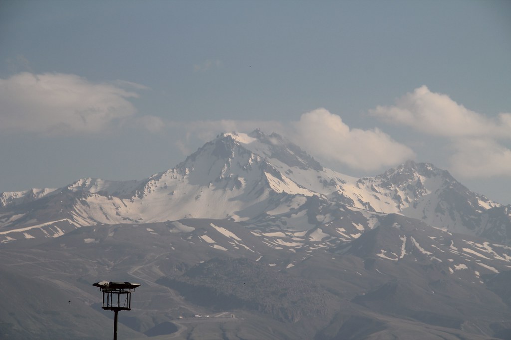
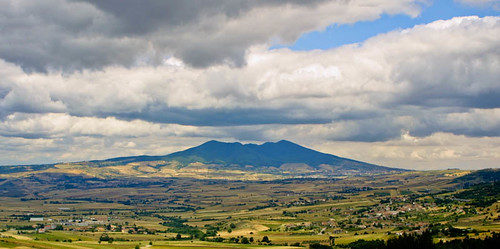
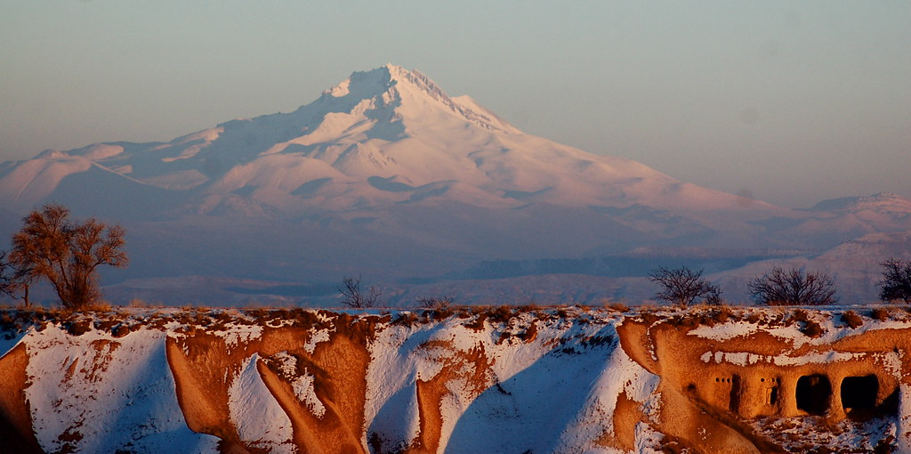
Approaching Mount Erciyes, the towering dormant stratovolcano dominates the Central Anatolian skyline with its imposing snow-capped peak. The volcanic landscape unfolds in stark contrasts — from barren ash slopes and jagged lava rock to lush valleys below. Hiking Erciyes is a visceral encounter with geological power, where every step brings you closer to the ancient forces that shaped this region. The ascent challenges your endurance and skill, rewarding you with panoramic views of Kayseri city and, on clear days, distant seas. Reaching the crater rim, the silence is profound, broken only by the whisper of wind and the crunch of volcanic scree beneath your boots. This trek is not just a climb; it is a journey into the heart of Anatolia’s volcanic heritage.
The Volcano Itself: Geological Background
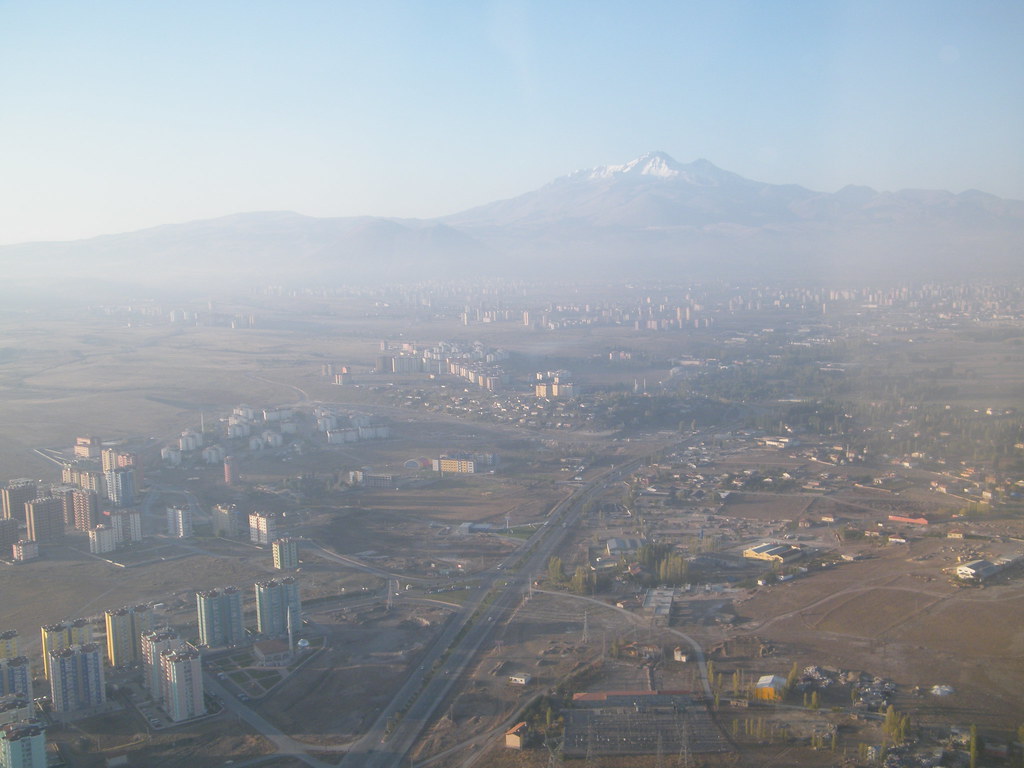
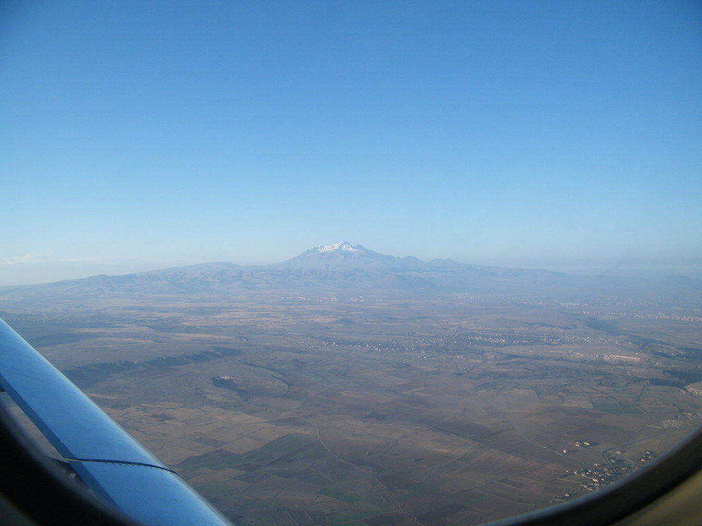
Mount Erciyes is a massive stratovolcano formed by successive lava flows and explosive eruptions over millions of years. It is the highest and most voluminous volcano in Central Anatolia, rising to 3,917 meters. The volcano’s last known eruption occurred around 6880 BC, rendering it dormant today. Its broad cone is composed primarily of andesitic and dacitic lava, interspersed with layers of volcanic ash and tuff. The summit area features a collapsed eastern flank, a remnant of a massive ancient eruption that reshaped the mountain’s profile. Volcanic minerals such as basalt and obsidian are found along the slopes, alongside fumaroles and steam vents that hint at residual geothermal activity. The volcanic dust and tufa from Erciyes have enriched the surrounding soils, contributing to the region’s agricultural fertility and the unique landscapes of nearby Cappadocia.
The Volcano Trek: Terrain and Hiking Experience
Trekking Mount Erciyes offers a diverse and demanding terrain that tests both physical endurance and technical skill. The ascent typically begins at the Erciyes Ski Resort base, situated around 2,200 meters, with an elevation gain of approximately 1,700 meters to the summit. Early sections of the hike traverse volcanic ash slopes and loose scree, requiring careful footing to avoid slips. The volcanic soil is often powdery and unstable, especially on steeper inclines, demanding trekking poles for balance and support. As you gain altitude, the terrain shifts to rugged volcanic rock formations and ridges. One notable challenge is the Devil’s Route, a steeper, shorter path characterized by loose scree and rock scrambling sections. This route includes exposed ridges and requires some class 5 rock climbing moves, with ropes installed in places for safety. It is recommended only for experienced climbers comfortable with scrambling and unstable rock. The more commonly chosen ridge route offers a longer but steadier ascent, winding along volcanic ridges with panoramic views. The trail is exposed to wind and temperature fluctuations, so layered clothing is essential. Altitude effects become noticeable above 3,000 meters, with thinner air and cooler temperatures. Hikers should pace themselves to acclimatize and avoid altitude sickness. The volcanic terrain is stark and dramatic, with sparse vegetation at higher elevations. The ground is littered with volcanic rocks, pumice, and ash deposits, creating a lunar-like landscape. The trail’s surface varies from compacted volcanic soil to loose gravel and jagged lava rock, requiring sturdy hiking boots with excellent grip. Weather conditions can change rapidly, with strong winds common near the summit. Temperature swings between sunlit slopes and shaded areas can be significant, so hydration and sun protection are critical. The combination of steep slopes, loose terrain, and altitude makes the Erciyes trek a moderate to demanding challenge, rewarding hikers with unmatched volcanic vistas and a profound sense of achievement.
What Makes This Volcano Trek Unique
Mount Erciyes stands out for its dual identity as both a dormant volcano and a premier ski resort, blending adventure trekking with winter sports. Its volcanic origins have sculpted a landscape of ash-covered slopes, lava ridges, and tufa formations that contrast sharply with the modern ski lifts and facilities at its base. The mountain’s proximity to the historic city of Kayseri and the surreal landscapes of Cappadocia adds cultural depth to the natural spectacle. The trek offers the rare opportunity to ascend a high-altitude stratovolcano with relatively easy access, supported by infrastructure such as ski lifts and mountain huts. The Devil’s Route provides a thrilling rock scrambling experience uncommon in many volcano hikes. On exceptionally clear days, hikers can glimpse both the Black Sea and the Mediterranean from the summit, a breathtaking testament to the mountain’s prominence. Erciyes’ volcanic dust has shaped the surrounding region’s agriculture and geology, linking the trek to the broader story of Anatolia’s volcanic past. The combination of geological grandeur, challenging terrain, and cultural richness makes Mount Erciyes a unique destination for volcano enthusiasts and adventure travelers alike.
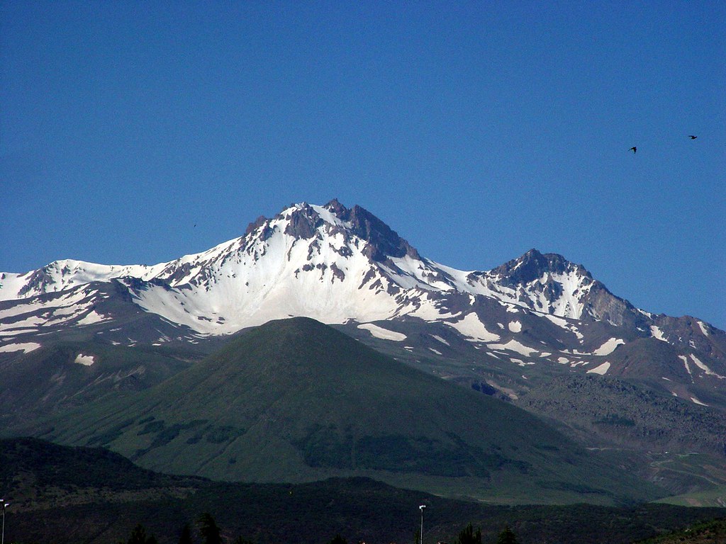
The Summit and Crater Experience
Reaching the summit of Mount Erciyes is a moment of profound awe. Standing at 3,917 meters, the panoramic views stretch across Central Anatolia, with the city of Kayseri sprawling below and the distant horizons revealing the Black and Mediterranean Seas on exceptionally clear days. The crater area, though no longer volcanically active, displays rugged volcanic rock and remnants of ancient lava flows. The air is thin and crisp, carrying the faint scent of minerals and earth. The summit’s exposed ridges offer a dramatic vantage point, where the silence is punctuated only by the wind’s howl and the occasional call of alpine birds. The terrain here is rocky and uneven, with patches of volcanic scree that shimmer under sunlight. The sense of standing atop a giant shaped by millennia of volcanic activity is humbling and exhilarating. Hikers often pause to absorb the vastness of the landscape, the interplay of light and shadow on the volcanic slopes, and the sheer scale of the mountain itself. The summit experience is both a physical triumph and a spiritual connection to the raw forces of nature.
Best Time to Trek Mount Erciyes
The optimal trekking season for Mount Erciyes is during the summer months, from June to September, when the weather is milder and the trails are free of snow. Daytime temperatures range from 5°C to 20°C, providing comfortable conditions for hiking. Early autumn, particularly September and October, offers clear skies and stable weather, ideal for summit attempts. Winter months, from December to March, transform Erciyes into a premier skiing destination, with heavy snowfall and cold temperatures often below freezing at higher elevations. Trekking during winter is not recommended due to snow cover, icy conditions, and increased avalanche risk. Spring and autumn shoulder seasons can be unpredictable, with possible snow at higher altitudes and variable weather. Hikers should monitor local forecasts and be prepared for sudden changes. Volcanic activity is dormant, so there are no restrictions related to eruptions. However, hikers should register with local authorities or military police near the mountain base as a safety protocol. Sunrise climbs are popular for spectacular views but require headlamps and warm clothing due to cold pre-dawn temperatures.
Trekking Routes and Trail Options on Mount Erciyes
Mount Erciyes offers several trekking routes varying in length and difficulty, catering to different levels of experience. The most popular starting point is the Erciyes Ski Resort base at approximately 2,200 meters. The Ridge Route, also known as the Classic Route, is the longer but less technical path, ascending along the mountain’s ridges. It offers steady elevation gain and panoramic views, making it suitable for hikers with moderate experience. This route typically takes 6 to 8 hours to reach the summit from the ski resort base. It is well-marked and avoids the loose scree sections found on other paths. The Devil’s Route is a shorter, more direct ascent characterized by steep scree slopes and loose volcanic rock. This route includes sections of rock scrambling and requires good climbing skills and experience with unstable terrain. The Devil’s Route is recommended only for advanced hikers comfortable with exposure and class 5 moves. It can take 4 to 6 hours to summit but demands caution and proper gear. The Chairlift-Assisted Route allows many trekkers to use the ski lifts to ascend to around 2,750 meters, reducing the elevation gain and physical strain. From the lift station, hikers can proceed to the Cobanini Camp area at 2,900 meters for acclimatization before the summit push. This option is popular for those seeking a more accessible climb or combining trekking with skiing. Guided tours are available through operators such as Montis Trips & Expeditions and Epik Encounter, offering multi-day itineraries with camping or mountain hut stays. Self-guided hikers should prepare for variable terrain and register with local authorities before starting. Each route provides unique perspectives of the volcanic landscape, with choices balancing challenge, safety, and scenic reward.
Difficulty Assessment of Mount Erciyes Trek
Mount Erciyes presents a moderate to demanding trekking challenge, influenced by altitude, terrain, and technical sections. The elevation of 3,917 meters means hikers must be prepared for thinner air and potential altitude sickness. The ascent involves approximately 1,700 meters of elevation gain from the ski resort base. Terrain difficulty varies by route. The ridge route is moderate, with steady climbs on volcanic soil and occasional rocky sections. The Devil’s Route is demanding, requiring rock scrambling skills and comfort with loose scree and exposure. This route is not suitable for beginners. Physical fitness is essential, with good cardiovascular endurance and leg strength needed to manage steep slopes and unstable footing. Technical climbing experience benefits those attempting the Devil’s Route or rock scrambling sections. Overall, the trek is classified as a demanding volcano ascent for experienced hikers and climbers, while the ridge route offers a moderate challenge for well-prepared trekkers.
Essential Volcano Trekking Gear for Mount Erciyes
Successful trekking on Mount Erciyes requires specialized gear tailored to volcanic terrain and high-altitude conditions. Sturdy hiking boots with aggressive tread are essential for loose volcanic scree and rocky surfaces. Trekking poles help maintain balance on unstable slopes and reduce leg strain. Layered clothing is necessary, including moisture-wicking base layers, insulating mid-layers, and a windproof, waterproof outer shell. Gloves and a warm hat protect against cold summit temperatures and wind exposure. A headlamp is important for early morning or late evening summit attempts. Sun protection includes high SPF sunscreen, sunglasses with UV protection, and a wide-brimmed hat. Carry a hydration system with sufficient water capacity, as volcanic terrain offers limited natural water sources. A lightweight backpack is needed to carry food, extra clothing, and emergency supplies. For the Devil’s Route, climbing gloves and a helmet are recommended due to rock scrambling sections. A gas mask or respirator is generally not required since volcanic gases are minimal due to dormancy. Proper preparation and gear ensure safety and comfort while navigating the demanding volcanic environment.
Safety and Volcanic Hazards on Mount Erciyes
Mount Erciyes is a dormant volcano with no recent eruptive activity, minimizing volcanic hazards. However, trekkers must remain vigilant about terrain-related risks and mountain weather. Key safety considerations include loose scree and unstable volcanic ash slopes that increase the risk of slips and falls, especially on steep sections like the Devil’s Route. Rockfall hazards exist in scrambling areas; wearing a helmet is advisable. Exposure to strong winds and rapid weather changes can cause hypothermia or disorientation. Altitude sickness is a concern above 3,000 meters; acclimatization and hydration are critical. Crater edges may be unstable; hikers should avoid venturing too close to steep drop-offs. Sudden storms or temperature drops require preparedness with appropriate clothing and emergency gear. Local authorities and mountain rescue teams monitor conditions, and hikers are encouraged to register their plans with the nearby military police station for safety tracking. Guided climbs with experienced leaders further reduce risks.
Permits, Guides, and Logistics for Mount Erciyes Trekking
Mount Erciyes is accessible to trekkers year-round without formal permit requirements. However, hikers must register their ascent plans with the Turkish military police station near the mountain base, presenting identification as a safety protocol. This registration helps authorities monitor visitor activity and respond to emergencies. Several reputable tour operators provide guided trekking and climbing services, including Montis Trips & Expeditions, Epik Encounter, and Sertan Hikes. These companies offer multi-day itineraries featuring airport transfers, accommodation, acclimatization hikes, and summit attempts. Guided tours often include camping at Cobanini Camp (2,900 meters) or stays in the mountain hut at 2,750 meters, providing shelter and rest before the summit push. Costs for guided tours vary depending on duration and services but typically range from moderate to premium pricing. Booking in advance is recommended, especially during peak trekking season (June to September). Logistically, the nearest major city is Kayseri, served by Kayseri Erkilet Airport (ASR) with regular domestic flights from Istanbul and Ankara. From Kayseri, a 30-minute drive or shuttle service connects to the Erciyes Ski Resort, the primary trailhead for climbs. Local taxis and private transfers are readily available. Hikers planning self-guided ascents should arrange transportation to the ski resort, carry sufficient supplies, and be prepared for variable weather and terrain. Ski lifts operate seasonally, typically opening at 9 am, and can assist in gaining elevation for those seeking to reduce physical strain. Accommodation options range from hotels in Kayseri city to lodges and guesthouses near the ski resort. The ski resort area also offers equipment rentals and basic amenities. Overall, Mount Erciyes combines accessible logistics with professional guiding services, making it a feasible yet adventurous volcano trekking destination.
Where to Stay Near Mount Erciyes and Nearby Bases
Accommodation options for Mount Erciyes trekkers are primarily concentrated around the Erciyes Ski Resort and the nearby city of Kayseri, approximately 25 to 30 kilometers away. At the Erciyes Ski Resort, several lodges and mountain huts provide convenient access to trailheads. The mountain hut at 2,750 meters offers basic shelter with insulated rooms, electricity depending on weather, and limited heating. This hut is ideal for acclimatization and early summit starts during multi-day climbs. Camping is also possible at the Cobanini Camp area (2,900 meters), where trekkers can experience a more rustic mountain environment. In Kayseri city, a range of hotels and guesthouses cater to various budgets. Notable accommodations include Tower 352, a modern apartment complex offering clean rooms and panoramic views of the city and mountains. Kayseri hotels provide amenities such as comfortable beds, modern bathrooms, and English-speaking staff. Staying in Kayseri offers cultural exploration opportunities, including visits to Seljuk monuments and the historic city center. Transportation between Kayseri and the ski resort is facilitated by shuttle services, taxis, and private transfers, typically taking 30 to 45 minutes. This proximity allows trekkers to combine urban comfort with mountain adventure. Additional lodging options near the ski resort include boutique hotels and guesthouses that provide ski-in/ski-out access during winter and easy trail access in summer. These accommodations often feature equipment rentals, dining facilities, and spa services. For those seeking a blend of cultural immersion and trekking convenience, Kayseri’s accommodations offer a strategic base with easy access to Mount Erciyes and surrounding attractions such as Cappadocia. Early booking is advisable during peak trekking and ski seasons to secure preferred lodging.