
Montaña de Guajara Volcano Trekking Guide: Conquer Tenerife’s Majestic Stratovolcano Rim
Explore Montaña de Guajara, Tenerife’s second highest peak, with this expert volcano trekking guide. Discover detailed trail routes, geological insights, terrain challenges, and practical logistics for hiking this dormant stratovolcano within Teide National Park.
Quick Volcano Snapshot
| Attribute | Value |
|---|---|
| Volcano type | Stratovolcano |
| Elevation | 2,718 m |
| Location | Canary Islands, Tenerife, Spain |
| Activity status | Dormant |
| Trekking difficulty | Moderate to Demanding |
| Typical trek duration | 4–6 hours |
| Altitude gain | 600–690 meters |
| Terrain type | Lava fields, pumice slopes, rocky paths, volcanic soil |
| Best season | March–June, September–November |
| Temperature range | Up to 40°C in summer; can be cold and windy at summit |
| Permit requirement | None required |
The Experience of Hiking Montaña de Guajara
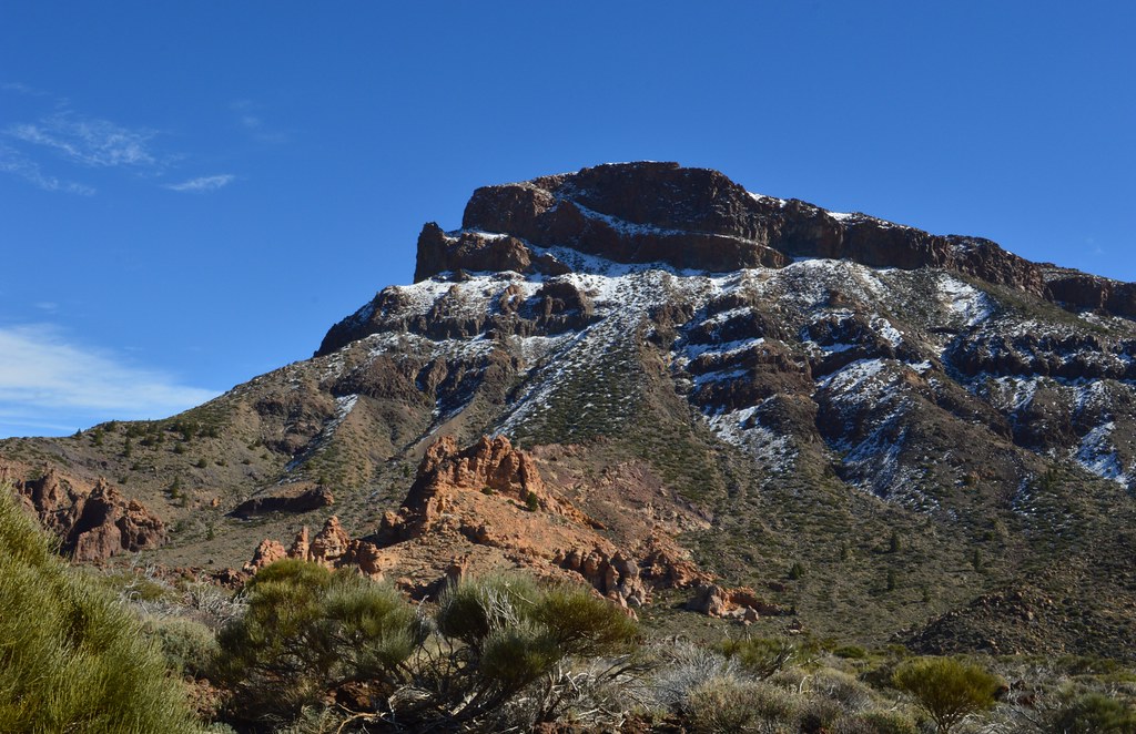
Approaching Montaña de Guajara, hikers are greeted by a vast volcanic landscape that stretches across Tenerife’s Teide National Park. The trail ascends through ancient lava fields and pumice slopes, revealing the raw geological power that shaped this stratovolcano. The barren terrain contrasts sharply with the vibrant flora clinging to the high-altitude environment. As you climb, the imposing silhouette of Mount Teide dominates the horizon, while the caldera’s vastness unfolds beneath your feet. Reaching the summit, a profound sense of accomplishment washes over you, surrounded by panoramic views of volcanic peaks, the Atlantic Ocean, and neighboring islands. The silence and expansive vistas evoke the timeless forces that formed this dramatic landscape.
Geological Background of Montaña de Guajara
Montaña de Guajara is a prominent stratovolcano forming part of Tenerife’s volcanic complex within the Canary Islands. It sits on the southern rim of the Las Cañadas caldera, a massive volcanic depression created by ancient eruptions and subsequent collapses. The volcano’s formation dates back hundreds of thousands of years, shaped by successive lava flows and explosive activity. Its rugged cliffs and ridges are composed of solidified basaltic lava and volcanic ash deposits. Notably, the summit area hosts remnants of the first high-altitude astronomical observatory in Europe, established in 1856 by astronomer Piazzi Smyth. The volcanic terrain features fumaroles and mineral deposits, including sulfur and other volcanic minerals, testifying to the region’s dynamic geological past. This dormant volcano offers a window into Tenerife’s fiery origins and ongoing volcanic evolution.
Terrain and Hiking Experience on Montaña de Guajara
The hike to Montaña de Guajara is a compelling journey through varied volcanic terrain that challenges and rewards trekkers alike. Starting from the Parador Nacional or the Cañada Blanca Visitor Centre, the trail initially traverses relatively flat sections along petrified lava fields, where the ground is hardened and cracked, offering a rugged walking surface. As the ascent begins, hikers encounter steep pumice slopes composed of loose volcanic ash and gravel, requiring careful footing and steady pacing to maintain balance. The volcanic soil here is porous and dry, with minimal vegetation, exposing hikers to direct sunlight and wind, making sun protection and layered clothing essential.
The route includes rocky paths with occasional scrambling over basaltic outcrops, demanding moderate agility and surefootedness. The trail ascends steadily to the Degollada de Guajara saddle, a wide pass between ridgelines, where panoramic views open up dramatically. From this vantage point, the final climb to the summit involves ridge walking along exposed edges, where wind gusts can be strong and temperatures drop noticeably. The altitude, reaching 2,718 meters, may cause mild effects such as breathlessness or fatigue, especially for those unaccustomed to high elevations.
Descending the loop trail involves navigating loose scree and gravel, which can be slippery, requiring trekking poles for stability. The entire circuit spans approximately 10 to 11 kilometers, typically completed in 4 to 6 hours depending on pace and breaks. The trail is well-marked but remote, with no water sources or shade, so hikers must carry sufficient supplies. The volcanic landscape is stark yet beautiful, with wildflower meadows appearing in spring, and the silence of the high altitude amplifies the sense of solitude and connection with the earth’s volcanic forces.
What Makes Montaña de Guajara Trek Unique
Montaña de Guajara offers a unique volcano trekking experience distinguished by its commanding position on the rim of the Las Cañadas caldera. Unlike the more crowded Mount Teide summit, Guajara provides solitude and unspoiled natural beauty. The trek rewards hikers with unobstructed 360-degree views of Tenerife’s volcanic landscape, including the towering Mount Teide, the ancient Pico Viejo volcano, and the vast caldera floor below. On clear days, the horizon reveals the islands of La Palma, La Gomera, El Hierro, and Gran Canaria, enhancing the sense of volcanic island interconnectedness.
The trail’s historical significance adds depth to the experience, as the summit was the site of one of Europe’s first high-altitude astronomical observatories, linking volcanic exploration with scientific discovery. The diverse high-altitude flora, such as Retama del Teide and rosalillo de cumbre, thrive in this harsh environment, offering botanical interest. The volcanic terrain’s combination of lava fields, pumice slopes, and rocky ridges creates a varied and engaging hiking environment that is both physically challenging and visually spectacular.
Summit and Crater Experience on Montaña de Guajara
Reaching the summit of Montaña de Guajara is a moment of profound awe and exhilaration. Standing at 2,718 meters, hikers are greeted by sweeping panoramic vistas that encompass the entire Teide National Park. The imposing peak of Mount Teide rises directly opposite, its snow-capped summit contrasting with the dark volcanic rock below. The vast Las Cañadas caldera spreads out beneath, a testament to the island’s volcanic past.
The summit plateau is exposed and often windy, with temperatures dropping sharply compared to the base. The air carries a faint scent of volcanic minerals, and the silence is punctuated only by the wind and distant bird calls. From this vantage point, the Atlantic Ocean shimmers on the horizon, and on clear days, multiple Canary Islands appear like jewels scattered across the sea.
Though Montaña de Guajara is dormant and lacks an active crater, the geological formations around the summit reveal the volcano’s fiery history. The remains of the 1856 Smyth observatory add a historical dimension, inviting reflection on humanity’s quest to understand the cosmos from volcanic heights. The summit experience is both sensory and contemplative, offering a rare connection to the earth’s volcanic forces and the island’s natural heritage.
Best Time to Trek Montaña de Guajara
The optimal seasons for trekking Montaña de Guajara are spring (March to June) and autumn (September to November), when temperatures are mild and the skies are generally clear. During these periods, the weather is cool and comfortable for hiking, and the risk of summer heat extremes or winter cold snaps is minimized. Summer months can bring intense heat, with temperatures reaching up to 40°C, making early starts and ample hydration essential.
Winter can be cold and windy at the summit, with occasional frost or snow on Mount Teide nearby, so adequate warm clothing is necessary. The trail is fully accessible year-round, but hikers should be prepared for rapid weather changes common in high-altitude volcanic environments. Avoiding the peak tourist season helps ensure a quieter, more solitary experience. Sunrise and sunset hikes are popular for dramatic lighting and cooler temperatures but require headlamps and careful planning.
Trekking Routes and Trail Options on Montaña de Guajara
Montaña de Guajara offers several well-established trekking routes, primarily forming a loop trail that starts and ends near the Parador Nacional hotel or the Cañada Blanca Visitor Centre within Teide National Park. The most popular route is the Montaña Guajara Circuit, approximately 10 to 11 kilometers in length, typically completed in 4 to 6 hours.
The trail begins at the Parador Nacional, near the Teleférico base station, and follows trail S-11 towards Degollada de Guajara, a broad saddle between ridgelines. This section features gradual ascents through lava fields and pumice slopes. From the saddle, hikers ascend the final stretch to the summit plateau, where panoramic views await.
The descent can be completed via trail S-7 or by continuing the loop on S-11, returning to the Parador. Alternative routes from the north include two main approaches starting at the Parador hotel: one over Degollada de Guajara pass, which is longer but less steep, and another over Degollada de Ucanca, a shorter, steeper, and more direct path with some exposed sections. Both routes take approximately two hours to reach the summit from the Parador.
These routes are well-marked but remote, requiring good navigation skills or GPS assistance. Guided hiking tours are available through operators such as Canary Hiking and Altos de Guajara Guided Hike, offering customized experiences with professional guides, liability insurance, and hiking equipment. No permits are required for these trails, making Montaña de Guajara an accessible yet adventurous volcanic summit option.
Difficulty Assessment of Montaña de Guajara Trek
Montaña de Guajara is classified as a moderate to demanding volcano trek. The trail involves steady elevation gain of approximately 600 to 690 meters over 10 to 11 kilometers, with sections of steep ascent and loose volcanic scree. The terrain varies from flat lava fields to pumice slopes and rocky ridges, requiring good balance and endurance.
Altitude plays a significant role in the trek’s difficulty, as the summit reaches 2,718 meters, where thinner air can cause breathlessness and fatigue, especially for those unacclimated. The exposed nature of the trail means hikers face strong winds and temperature fluctuations, adding to the challenge.
Technical climbing skills are not required, and the route is a walk-up with some scrambling over rocks. Fitness levels should be moderate to high, with hikers prepared for a full day of hiking including ascent and descent. Proper footwear, trekking poles, and physical preparation are recommended to safely navigate the varied volcanic terrain.
Essential Volcano Trekking Gear for Montaña de Guajara
Successful hiking on Montaña de Guajara requires gear tailored to volcanic terrain and high-altitude conditions. Essential items include sturdy hiking boots with excellent grip for rocky and loose pumice surfaces. Trekking poles are highly recommended to aid balance on steep and slippery slopes.
Layered clothing is necessary to adapt to temperature changes, including a windproof jacket for summit exposure and a warm base layer for cooler conditions. Sun protection is critical due to the lack of shade: bring a wide-brimmed hat, UV-blocking sunglasses, and high-SPF sunscreen.
Hydration systems or water bottles with at least 2 to 3 liters of water capacity are vital, as no water sources exist on the trail. A headlamp is useful for early morning or late afternoon hikes. Additionally, carrying a map or GPS device with offline trail data ensures safe navigation. Optional gear includes a lightweight backpack, first aid kit, and camera to capture the stunning volcanic vistas.
Safety and Volcanic Hazards on Montaña de Guajara
While Montaña de Guajara is a dormant volcano with no current eruptive activity, hikers must remain vigilant to natural hazards inherent to volcanic landscapes. The terrain includes loose scree, pumice slopes, and rocky outcrops that can cause slips and falls. Careful footing and use of trekking poles reduce injury risk.
Exposure to strong winds and rapid weather changes at high altitude can lead to hypothermia or heat exhaustion if unprepared. The trail is fully exposed with no shade, increasing the risk of sunburn and dehydration. Carrying sufficient water and sun protection is essential.
Though volcanic gases are not a concern here, hikers should respect park regulations and avoid venturing off marked trails to protect fragile ecosystems and ensure safety. Emergency services are accessible via the national park authorities, who monitor volcanic activity and provide warnings if conditions change. Always check weather forecasts and park alerts before hiking.
Permits, Guides, and Logistics for Montaña de Guajara Trek
Montaña de Guajara is notable for its accessibility, as no special permits or fees are required to hike its trails within Teide National Park. This contrasts with the nearby Mount Teide summit, which requires advance permits. The absence of permit restrictions makes Guajara an attractive option for independent trekkers seeking a high-altitude volcanic experience without bureaucratic hurdles.
Guided tours are available from reputable local operators such as Canary Hiking and Altos de Guajara Guided Hike. These companies offer private and group hikes tailored to various fitness levels, including knowledgeable guides fluent in multiple languages, liability and accident insurance, and provision of walking sticks. Guided hikes provide added safety, detailed geological and historical commentary, and logistical support.
Trailheads are conveniently located near the Parador Nacional hotel and the Cañada Blanca Visitor Centre, both accessible by car and public transport. Parking is available but limited, so early arrival is recommended. Bus lines 342 and 348 connect the park with major towns like Puerto de la Cruz, facilitating access without a vehicle.
Hikers should prepare for a full day on the trail, carrying sufficient water and supplies, as no services exist along the route. Weather conditions can vary rapidly; checking forecasts and park advisories is advised. The park is open year-round, and the best hiking seasons are spring and autumn for favorable temperatures and clear skies.
Overall, Montaña de Guajara offers a well-supported yet wild trekking experience, combining ease of access with the solitude and grandeur of Tenerife’s volcanic landscapes.
Where to Stay and Nearby Bases for Montaña de Guajara
The primary base for hiking Montaña de Guajara is the Parador de Las Cañadas del Teide, the only hotel located inside Teide National Park. Situated at approximately 2,150 meters elevation, the Parador offers unparalleled proximity to the trailhead, allowing hikers to start early and avoid parking congestion. The hotel features comfortable rooms, a restaurant serving local cuisine, and amenities including parking and visitor information.
For travelers seeking more budget-friendly options, nearby towns such as Vilaflor and La Orotava provide a range of accommodations including guesthouses, hostels, and boutique hotels. Vilaflor, located about 20 kilometers south of the park, is the highest village in Tenerife and offers charming rural lodging with easy road access to the park.
Puerto de la Cruz and Santa Cruz de Tenerife, larger towns on the island, serve as convenient bases with extensive hotel options, dining, and transport connections. From these towns, regular bus services (lines 342 and 348) run to the park area, making day trips feasible.
Camping is not permitted within the national park, so overnight stays must be arranged in established accommodations. Early booking is recommended during peak hiking seasons to secure rooms near the park. Staying at the Parador or Cañada Blanca Visitor Centre area maximizes hiking time and minimizes travel logistics, enhancing the overall trekking experience.