
Hiking Acatenango Volcano: The Ultimate Guide to Guatemala’s Demanding Stratovolcano Trek
Discover the challenging and rewarding Acatenango Volcano hike in Guatemala. This demanding trek offers spectacular views of the erupting Fuego Volcano, diverse terrain, and an unforgettable overnight camping experience at nearly 4,000 meters elevation.
Quick Volcano Snapshot
| Attribute | Value |
|---|---|
| Volcano type | Stratovolcano |
| Elevation | 3,976 m (13,044 ft) |
| Location | South-Central Guatemala, near Antigua |
| Activity status | Dormant |
| Trekking difficulty | Demanding |
| Typical trek duration | 2 days, 1 night |
| Altitude gain | 1,600 m (5,253 ft) |
| Terrain type | Volcanic ash slopes, rocky paths, cloud forest, alpine terrain |
| Best season | Dry season (November to April) |
| Temperature range | Daytime 10-20°C; Nighttime can drop below freezing (0 to -5°C) |
| Permit requirement | No permit required, but park entrance fee and mandatory guide required |
The Experience of Hiking Acatenango Volcano
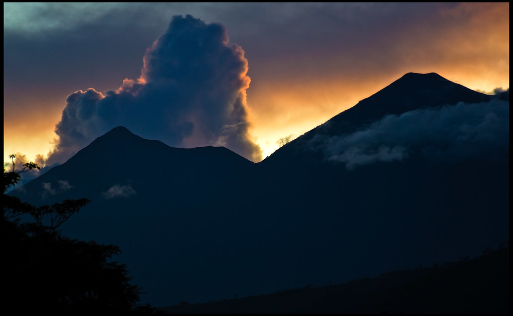
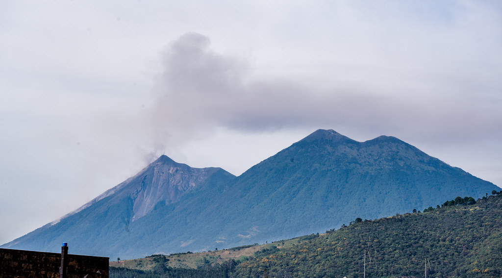
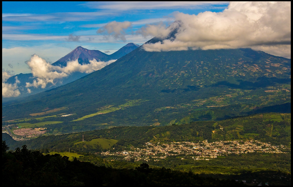
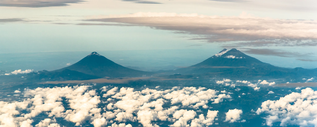
Approaching Acatenango Volcano, hikers are greeted by a dramatic landscape of layered volcanic slopes rising sharply into the sky. The trail winds through lush cloud forests before emerging into barren, rugged alpine terrain. The air thins as you ascend, and the temperature drops, heightening the sense of isolation and raw geological power. Camping near the summit, you witness the spectacular eruptions of the neighboring Fuego Volcano, its fiery bursts illuminating the night sky. Reaching Acatenango’s summit at dawn rewards trekkers with panoramic views of Guatemala’s highlands and the glowing lava fountains of Fuego, a profound encounter with nature’s elemental forces.
Geological Background of Acatenango Volcano
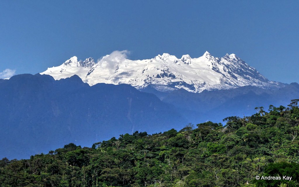
Acatenango is a classic stratovolcano formed by successive layers of hardened lava, ash, and volcanic debris. Standing at 3,976 meters, it is the third highest volcano in Central America. Its formation is tied to the subduction of the Cocos Plate beneath the Caribbean Plate, which fuels volcanic activity along Guatemala’s volcanic arc. Although Acatenango itself is dormant, with its last eruption recorded in 1972, it is part of the La Horqueta volcanic complex alongside the highly active Fuego Volcano. The volcano features a prominent conical shape with steep slopes composed of volcanic ash and rock. Its summit crater is broad and eroded, reflecting its dormancy. The area exhibits fumaroles and sulfur deposits, remnants of past volcanic activity, and the terrain showcases diverse volcanic minerals and formations. This geological setting provides a vivid window into the dynamic processes shaping Central America’s volcanic landscape.
Terrain and Hiking Experience on Acatenango Volcano
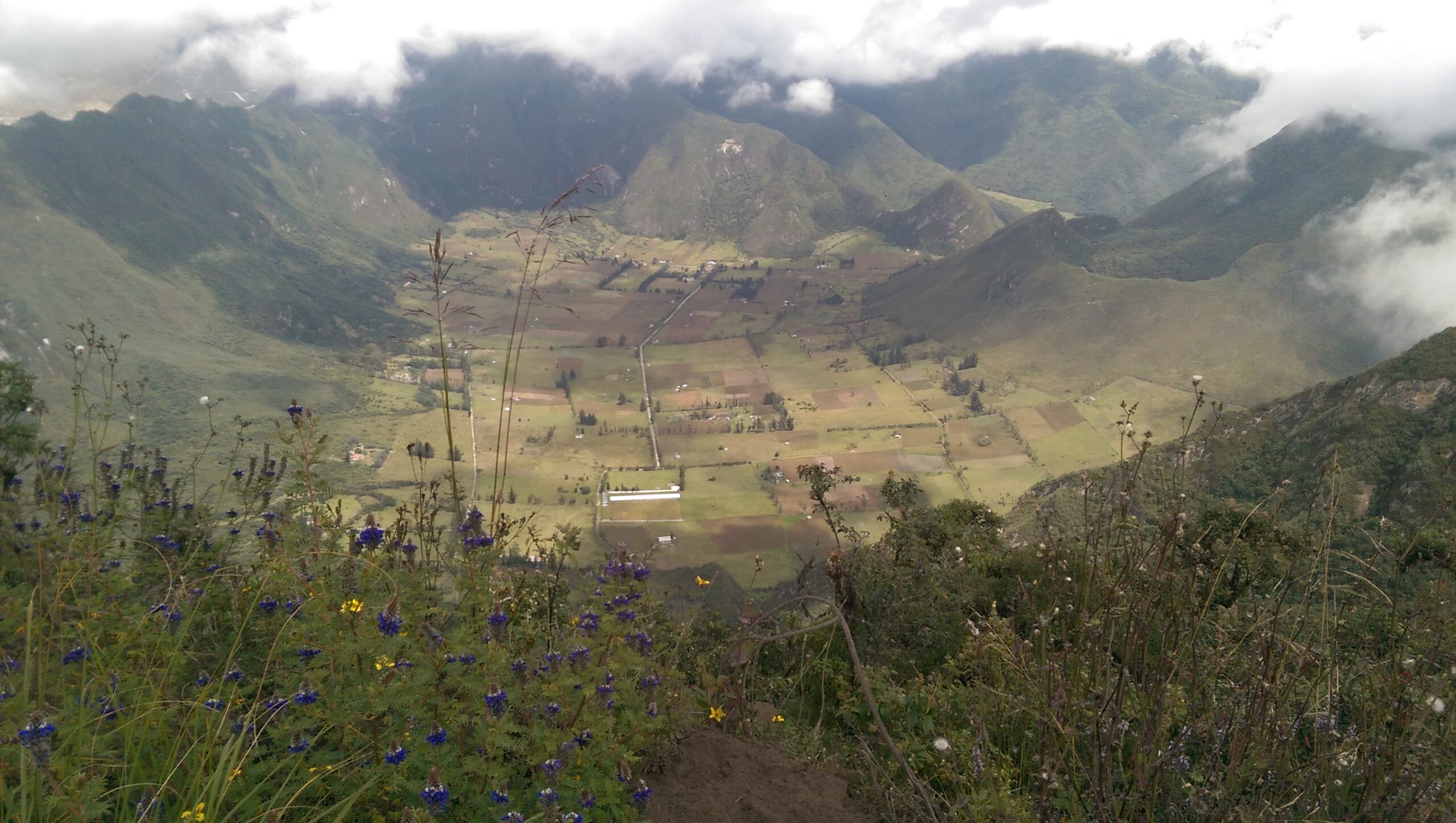
The Acatenango hike is a physically demanding trek that challenges hikers with steep ascents, varied terrain, and high altitude. The trail begins at the village of La Soledad, ascending through farmland and dense cloud forests where humidity and cooler temperatures prevail. As you climb higher, the forest thins and gives way to volcanic ash slopes and rocky paths. The terrain here is loose and crumbly, composed of volcanic sand and pumice that can make footing unstable and require careful navigation. Hikers often face steep switchbacks that test endurance and balance. The final sections near base camp and the summit are exposed alpine zones with sparse vegetation, where wind and cold temperatures intensify the challenge. The altitude, reaching nearly 4,000 meters, can cause shortness of breath and fatigue, demanding a steady pace and acclimatization. Overnight camping at base camp offers a chance to rest and acclimate, but temperatures can drop below freezing, requiring warm gear. The trail’s ruggedness and elevation gain of over 1,600 meters make this a demanding trek suited for those with good fitness and preparation. Despite the difficulty, the trail rewards hikers with breathtaking views of the erupting Fuego Volcano, whose frequent lava bursts and ash plumes create a mesmerizing spectacle. The combination of ecological zones, from tropical forests to volcanic desert, and the dramatic volcanic activity nearby, makes the Acatenango hike a uniquely immersive experience in volcanic terrain.
What Makes the Acatenango Volcano Trek Unique
Acatenango’s trek is distinguished by its proximity to the highly active Fuego Volcano, providing an unparalleled vantage point to witness near-constant volcanic eruptions. Unlike many volcano hikes, campers on Acatenango can watch Fuego’s fiery lava fountains and ash explosions from a safe distance throughout the night. The trek’s ecological diversity is also remarkable, traversing four distinct microclimates ranging from tropical dry forests to high alpine zones. The experience of camping at nearly 4,000 meters elevation, above the clouds, with the dramatic backdrop of erupting lava, creates a surreal and otherworldly atmosphere. The challenging ascent, combined with the reward of spectacular volcanic displays and panoramic views of Guatemala’s highlands, sets Acatenango apart as one of the most thrilling volcano treks in Central America.
Summit and Crater Experience on Acatenango
Reaching the summit of Acatenango is a triumphant moment marked by sweeping views of the surrounding volcanic landscape. From this vantage point, hikers gaze across the valley to Fuego Volcano, whose frequent eruptions send glowing lava and ash plumes into the sky. The summit’s crater is broad and eroded, with rocky outcrops and patches of volcanic debris. The air is thin and crisp, and the cold intensifies the sense of remoteness. The smell of sulfur lingers faintly, a reminder of the volcano’s fiery origins. The silence is punctuated by the distant rumble and crackle of Fuego’s eruptions, creating a sensory experience that is both humbling and exhilarating. The panoramic vistas extend to Guatemala’s highlands and, on clear days, to the Pacific coastline, offering a breathtaking reward for the strenuous climb.
Best Time to Trek Acatenango Volcano
The optimal time to hike Acatenango is during Guatemala’s dry season, from November to April, when skies are clearer and trails are less muddy. This season increases the likelihood of unobstructed views of Fuego’s eruptions and safer hiking conditions. The wet season, May to October, brings frequent rain, slippery trails, and reduced visibility, which can obscure volcanic activity and increase risks. Temperatures vary significantly; daytime at lower elevations can be mild, but nights near the summit are cold, often dropping below freezing. Early morning summit attempts typically start around 4 a.m. to catch sunrise and avoid afternoon weather changes. It is essential to monitor volcanic activity reports and weather forecasts before planning the trek, as sudden weather shifts and volcanic hazards can impact safety.
Routes and Trail Options for Acatenango Volcano
The primary route to Acatenango’s summit begins at La Soledad village, near the entrance to Acatenango National Park. The standard trek covers approximately 8.6 miles (13.8 km) round trip with an elevation gain of about 1,600 meters (5,253 feet). Most hikers undertake a two-day, one-night itinerary, ascending 4 to 7 hours to base camp, camping overnight, and then summiting early the next morning before descending. Some tour operators offer a challenging day hike option, but this is less popular due to the strenuous nature and missing the nighttime eruptions of Fuego. For the adventurous, an optional side hike to Fuego’s knife ridge is available, though it is more difficult and only accessible with specialized guided tours due to safety concerns. Multiple tour companies provide guided hikes with variations in base camp locations and amenities, including rustic cabins or tents. Transportation from Antigua to the trailhead is typically included in tours, and some operators offer 4×4 vehicle access to shorten the initial ascent. Regardless of the route chosen, all hikers must be accompanied by licensed guides for safety and park regulations.
Difficulty Assessment of the Acatenango Trek
Acatenango is classified as a demanding volcano trek due to its steep, sustained elevation gain, high altitude, and challenging terrain. The trail requires hikers to ascend over 1,600 meters, often on loose volcanic ash and rocky paths, which can be physically taxing. Altitude effects such as shortness of breath and fatigue are common near the summit at nearly 4,000 meters. While no technical climbing skills or equipment are needed, a good level of fitness, endurance, and acclimatization is essential. The cold temperatures at night and exposure to wind add to the challenge. The trek is suitable for experienced hikers and those prepared for strenuous activity, but beginners should train adequately and consider guided tours for safety and support.
Essential Gear for Hiking Acatenango Volcano
Proper gear is crucial for a safe and comfortable Acatenango hike. Recommended items include sturdy hiking boots with good grip for loose volcanic terrain, trekking poles to aid balance and reduce strain, and layered clothing to adapt to temperature changes. A warm, insulated jacket and thermal layers are necessary for cold nights at base camp and summit. A headlamp is essential for early morning summit ascents in the dark. Hydration systems and high-energy snacks help maintain stamina. Sun protection, including a hat, sunglasses, and sunscreen, is important as the trail offers little shade. A gas mask or respirator is generally not required, as Acatenango is dormant, but some hikers bring masks for potential ash exposure from Fuego. Camping gear is typically provided by tour operators, but personal sleeping bags rated for sub-zero temperatures are recommended for added comfort.
Safety and Volcanic Hazards on Acatenango Trek
While Acatenango is dormant, safety remains paramount due to the challenging terrain and proximity to the active Fuego Volcano. The trail’s loose volcanic ash and pumice can cause slips and falls, especially on steep slopes. Altitude sickness is a risk at nearly 4,000 meters, with symptoms ranging from headaches to severe illness; hikers should acclimate properly and monitor their condition. Weather can change rapidly, bringing cold temperatures, wind, and rain, increasing exposure risks. The nearby Fuego Volcano erupts frequently, but the distance to Acatenango’s base camp and summit is generally safe; however, hikers must heed warnings and avoid venturing too close to Fuego. Guatemala’s National Institute for Seismology, Volcanology, Meteorology, and Hydrology (INSIVUMEH) monitors volcanic activity and issues alerts. It is mandatory to hike with licensed guides who are trained in emergency response and can make informed decisions about safety. Proper preparation, respect for the environment, and adherence to park regulations are essential for a safe trek.
Permits, Guides, and Logistics for Acatenango Volcano Trek
Hiking Acatenango Volcano requires an entrance fee to Acatenango National Park, currently around Q100 to Q110 (approximately $13-$14 USD), payable at the trailhead. While no formal permit is required, park regulations mandate that all hikers be accompanied by licensed local guides to ensure safety and environmental protection. Numerous reputable tour operators in Antigua offer guided Acatenango treks, including OX Expeditions, Old Town Outfitters, Tropicana Hostel & Tour Agency, Adventure Guatemala, and others. These companies provide comprehensive packages that typically include transportation from Antigua to the trailhead, professional guides, camping equipment (tents, sleeping mats, sleeping bags), meals, and park fees. Prices vary depending on the level of service, group size, and itinerary length, with overnight tours generally costing between $70 and $150 USD per person. Booking in advance is recommended, especially during the dry season, to secure spots with trusted operators. Guides are trained in first aid and emergency procedures, critical given the hike’s altitude and terrain challenges. Some operators also offer optional add-ons such as the ‘Double Whammy’ hike, combining Acatenango and Fuego Volcano ascents. Hikers should bring sufficient cash for entrance fees and tips, as many services do not accept cards. Public transportation from Antigua to the trailhead is available but less convenient than private transfers arranged by tour companies. Overall, the logistical framework around Acatenango is well-established, supporting safe and rewarding trekking experiences.
Where to Stay Near Acatenango Volcano
Most hikers base themselves in the colonial city of Antigua Guatemala, located approximately 30 kilometers (1.5-hour drive) from Acatenango’s trailhead. Antigua offers a wide range of accommodations, from budget hostels to boutique hotels, providing convenient access to tour operators and transport services. Popular options include the Tropicana Hostel, which also operates its own Acatenango tours and offers gear rentals and warm sleeping bags, ideal for the cold summit nights. For those seeking comfort, Antigua’s hotels provide amenities such as hot showers, restaurants, and cultural experiences. At the volcano itself, overnight camping is arranged by tour operators at base camps near the summit, typically consisting of tents or rustic A-frame shelters equipped with sleeping mats and bags. Some operators provide cabins for added warmth and shelter, a valued option during unexpected cold weather or snow. Facilities at base camp are basic, with limited toilet access and no running water, so hikers should prepare accordingly. Booking tours that include camping equipment and meals simplifies logistics. For travelers wanting to extend their stay, Antigua’s vibrant atmosphere, colonial architecture, and local markets offer enriching cultural experiences before or after the trek.