Trekking Tajumulco Volcano: Conquer Central America’s Highest Peak
Tajumulco Volcano, Guatemala’s dormant stratovolcano, stands as the highest peak in Central America at 4,220 meters. This comprehensive trekking guide covers the geological background, terrain challenges, trekking routes, logistics, and accommodation options for adventurers seeking to summit this majestic volcano.
Quick Volcano Snapshot
| Attribute | Value |
|---|---|
| Volcano type | Stratovolcano |
| Elevation | 4,220 meters (13,845 feet) |
| Location | San Marcos, Western Guatemala |
| Activity status | Dormant |
| Trekking difficulty | Moderate |
| Typical trek duration | 1-2 days |
| Altitude gain | Approximately 1,400 meters |
| Terrain type | Rocky paths, dirt trails, steep ash slopes, alpine vegetation |
| Best season | Dry season (November to April) |
| Temperature range | 21°F to 49°F (-6°C to 9°C), colder at summit especially at night |
| Permit requirement | No formal permit required; local fees may apply |
The Experience of Hiking Tajumulco Volcano
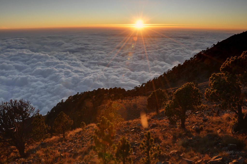
Approaching Tajumulco Volcano, the highest peak in Central America, is an awe-inspiring journey through diverse landscapes. The trek begins in lush pine and oak forests, gradually giving way to sparse alpine vegetation as you ascend. The volcanic terrain reveals layers of hardened lava and pumice, with the air growing thinner and cooler. The dramatic contrast between the verdant lower slopes and the barren summit creates a powerful sense of geological grandeur. Reaching the crater rim, hikers are rewarded with panoramic views stretching to Mexico, the Pacific Ocean, and a chain of volcanoes. The emotional impact of standing above the clouds, witnessing sunrise or sunset from this lofty vantage point, is unforgettable.
Geological Background of Tajumulco Volcano
Tajumulco is a stratovolcano formed by successive layers of andesitic and dacitic lava flows, pumice, and volcanic ash. It rises prominently in the Sierra Madre de Chiapas mountain range of western Guatemala. The volcano features two summits, with the main summit hosting a crater approximately 50 to 70 meters wide. Its formation involved complex volcanic activity over millennia, building a conical shape atop an escarpment facing southwest. Although currently dormant, historical records indicate past eruptions, and the volcano remains an important geological landmark. The volcanic minerals and rock formations reflect the dynamic processes of Central America’s tectonic activity. The surrounding Biosphere Reserve protects unique ecosystems shaped by the volcano’s elevation gradient.
Terrain and Hiking Experience on Tajumulco Volcano
The trek to Tajumulco’s summit is a demanding but rewarding adventure that challenges hikers with varied terrain and altitude effects. The trail begins near the village of Tacaná, ascending through dense pine and oak forests where the ground is covered with soft soil and occasional rocky patches. As elevation increases, the vegetation thins, and hikers encounter rugged, rocky paths composed of hardened lava and volcanic ash. The terrain becomes steeper and more exposed, with loose pumice and scree slopes requiring careful footing. The final ascent involves navigating steep ash slopes and rocky ridges, where wind conditions can be strong and temperatures drop sharply, especially near the summit.
Altitude gain of approximately 1,400 meters over a 12-kilometer round trip demands good physical fitness and acclimatization to avoid altitude sickness. The trail is well-marked but can be slippery in wet conditions, so trekking poles and sturdy boots with good grip are essential. Hikers often camp at a base camp located about 200 meters below the summit to rest and acclimate before the final push. The trail offers stunning views of surrounding volcanoes, valleys, and on clear days, the Pacific Ocean. Wildlife sightings include various bird species and small mammals adapted to high-altitude environments. The experience combines the challenge of steep climbs with the serenity of remote wilderness, culminating in a dramatic summit panorama.

What Makes the Tajumulco Volcano Trek Unique
Tajumulco Volcano stands out as Central America’s highest peak, offering a rare high-altitude trekking experience in a relatively untouched natural setting. Unlike more crowded volcanoes, Tajumulco provides solitude and a raw connection with nature. The trek’s unique feature is the opportunity to stand above the clouds and witness breathtaking sunrises and sunsets that paint the sky with vivid colors. The volcano’s dual summits and dormant crater add geological intrigue, while the panoramic views encompass multiple volcanic peaks, the Pacific Ocean, and the border with Mexico. The diverse ecosystems from lush forests to alpine tundra create a rich habitat for specialized flora and fauna. This trek combines physical challenge with cultural significance, as it lies within the heart of the Mayan world, enriching the adventure with historical depth.
Summit and Crater Experience on Tajumulco Volcano
Reaching the summit of Tajumulco Volcano is a moment of profound achievement and sensory immersion. The air is thin and crisp, carrying a faint scent of volcanic minerals. The dormant crater, roughly 50 to 70 meters wide, invites exploration along its rim, where hikers can safely circumnavigate to capture sweeping views. From this vantage point, the landscape unfolds dramatically: a tapestry of volcanic peaks, deep valleys, and distant horizons including the Pacific Ocean and Mexico’s mountain ranges. The summit is often windy and cold, with temperatures dropping below freezing at night, intensifying the rawness of the environment. The silence is punctuated only by the wind and the distant calls of birds. Watching the sunrise here, as the sky transitions from darkness to a palette of fiery hues, is an unforgettable experience that connects hikers to the primal forces shaping the Earth.
Best Time to Trek Tajumulco Volcano
The optimal time to hike Tajumulco Volcano is during the dry season, from November to April, when trails are less muddy and visibility is generally clearer. During these months, daytime temperatures range between 21°F and 49°F, though nights at the summit can be much colder, often below freezing. The wet season, spanning May to October, brings frequent rain and cloud cover, which can obscure views and make the trail slippery and hazardous. Early morning starts are recommended to avoid afternoon clouds and to experience spectacular sunrises from the summit. Hikers should monitor local weather forecasts and volcanic activity reports, although Tajumulco is dormant. Proper preparation for cold, wind, and sudden weather changes is essential year-round.
Trekking Routes and Trail Options on Tajumulco Volcano
The primary trekking route to Tajumulco’s summit begins near the village of Tacaná, accessible from San Marcos. The trail covers approximately 12 kilometers round trip with an elevation gain of about 1,400 meters. Most hikers opt for a two-day trek, camping at a base camp roughly 200 meters below the summit to acclimate and rest before the final ascent. The first day involves a steady climb through forested slopes to the campsite, while the second day starts early for the summit push, often timed to witness sunrise.
Alternatively, experienced hikers may attempt a challenging one-day ascent, starting very early from San Marcos or nearby trailheads. This option requires excellent fitness and acclimatization due to the rapid altitude gain. The trail is well-marked but includes steep and rocky sections, with some loose scree near the summit. Guided tours are widely available and recommended for safety and logistical support, though independent trekking is possible with proper preparation and GPS navigation.
Additional routes include variations that explore the volcano’s dual summits and crater rim, offering extended hiking options for those seeking a more comprehensive experience. Local guides provide valuable insights into trail conditions, cultural context, and safety precautions.
Difficulty Assessment of Tajumulco Volcano Trek
Tajumulco Volcano is classified as a moderate volcano trek, demanding good physical fitness and acclimatization to high altitude. The trail involves sustained elevation gain of approximately 1,400 meters over rocky and sometimes steep terrain. While technical climbing skills are not required, hikers must be prepared for loose scree, ash slopes, and variable weather conditions including cold temperatures and strong winds near the summit. Altitude sickness is a risk due to the peak’s elevation at 4,220 meters, so pacing and hydration are critical. The trek is suitable for hikers with prior mountain experience and endurance for long hours of walking. Beginners should consider guided tours with acclimatization stops or opt for the two-day itinerary to reduce strain.
Essential Volcano Trekking Gear for Tajumulco
Proper gear is crucial for a safe and comfortable trek on Tajumulco Volcano. Recommended items include sturdy hiking boots with good grip to handle rocky and loose terrain, trekking poles to aid balance on steep slopes, and gaiters to protect against volcanic ash and debris. Layered clothing is essential to adapt to temperature fluctuations, including moisture-wicking base layers, insulating mid-layers, and a windproof, waterproof outer shell. A warm hat, gloves, and thermal socks are necessary for cold summit conditions. Carry a headlamp for early morning or nighttime hiking, ample water (at least 3 liters), and high-energy snacks. Sun protection such as sunscreen, sunglasses, and a wide-brimmed hat is important due to high UV exposure. A gas mask or respirator is generally not required as Tajumulco is dormant, but hikers should be aware of any sudden changes in volcanic activity.
Safety and Volcanic Hazards on Tajumulco Volcano
Although Tajumulco is currently dormant, safety precautions remain vital. The primary hazards include altitude sickness due to the high elevation, sudden weather changes with cold temperatures and strong winds, and challenging terrain with loose rocks and steep ash slopes that increase the risk of slips and falls. The crater edges, while stable, should be approached cautiously to avoid accidents. There is no significant risk of volcanic gas emissions or eruptions at present, but hikers should stay informed through local authorities and volcanic monitoring agencies. It is advisable to hike with a guide or in groups, carry a first aid kit, and inform others of your itinerary. Proper acclimatization and hydration are key to preventing altitude-related illnesses.
Permits, Guides, and Logistics for Hiking Tajumulco Volcano
Hiking Tajumulco Volcano does not require a formal government permit or entrance fee, making it accessible for independent trekkers. However, local communities may request small contributions or fees, especially when hiring guides or using camping facilities. Guided tours are widely available and recommended for safety, navigation, and cultural insight. Notable tour operators include Mayan Gateway, Quetzaltrekkers, Casa Xelaju, and Much Better Adventures, all offering multi-day trekking packages with transportation, meals, camping gear, and certified guides.
Logistically, most treks start from San Marcos, accessible by bus from Guatemala City or Quetzaltenango (Xela). From San Marcos, local taxis or tuk-tuks transport hikers to the trailhead near Tacaná village. Tours typically include hotel pickup in Quetzaltenango, a two-hour drive to San Marcos, breakfast stops, and briefing sessions before the hike. Camping at base camp is standard for two-day treks, with meals provided by guides. Independent hikers should prepare to carry their own gear, food, and water, as there are no facilities along the trail. Weather conditions can affect trail accessibility, so checking recent trail reports and local advice is essential before departure.
Where to Stay and Nearby Bases for Tajumulco Volcano Trek
San Marcos serves as the primary base for Tajumulco Volcano treks, offering a range of accommodations from budget hostels to mid-range hotels. Popular options include Hotel Villa Real, known for its proximity to the trailhead and comfortable amenities, and local guesthouses that provide authentic cultural experiences. Quetzaltenango (Xela), approximately 2 to 3 hours away by road, is a larger city favored by many trekkers for its wider selection of hotels, hostels, and gear rental shops. Casa Xelaju in Xela offers combined lodging and guided trekking packages, including camping equipment rental.
For those undertaking the two-day trek, camping is arranged at a designated base camp located about 200 meters below the summit, where tents, meals, and basic facilities are provided by tour operators. This camp offers stunning views and a restful environment for acclimatization. Nearby towns such as Tacaná and Sabinal provide additional lodging and local services. Transportation options include public buses, private shuttles, and taxis connecting San Marcos, Xela, and trailheads. Early booking is recommended during peak trekking seasons to secure accommodations and guide services.