
Mount Agung Volcano Trekking Guide: Conquer Bali’s Sacred Active Stratovolcano
Mount Agung, Bali’s highest and most sacred active stratovolcano, offers a demanding and thrilling trekking experience. This comprehensive guide covers its geology, trekking routes, safety tips, permit requirements, and accommodation options for adventurers seeking to summit this iconic peak.
Quick Volcano Snapshot
| Attribute | Value |
|---|---|
| Volcano type | Stratovolcano |
| Elevation | 3,142 meters (10,308 feet) |
| Location | Karangasem Regency, Bali, Indonesia |
| Activity status | Active |
| Trekking difficulty | Demanding |
| Typical trek duration | 8–12 hours |
| Altitude gain | 1,500 meters (~5,000 feet) |
| Terrain type | Steep volcanic ash slopes, rocky trails, jungle paths, lava fields |
| Best season | April to September (dry season) |
| Temperature range | 5°C to 20°C near summit; warmer at base |
| Permit requirement | Required; guided tours strongly recommended |
The Experience of Hiking Mount Agung
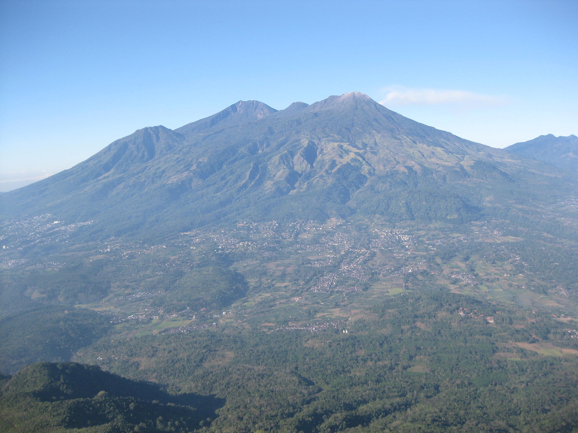
Approaching Mount Agung, the tallest and most sacred peak in Bali, is an encounter with raw geological power and spiritual depth. The landscape shifts dramatically from lush tropical forests at the base to barren volcanic rock and ash slopes near the summit. As you ascend through the night, the sky reveals a tapestry of stars, and the air grows thinner and cooler. Reaching the summit at dawn, you witness a breathtaking sunrise above a sea of clouds, with panoramic views stretching across Bali and neighboring islands. The immense crater looms nearby, steaming gently, a reminder of the volcano’s active nature. This trek is not only a physical challenge but a profound journey into Bali’s volcanic heart and cultural soul.

Geological Background of Mount Agung
Mount Agung is a towering stratovolcano formed by layers of hardened lava, ash, and volcanic debris. Rising to 3,142 meters, it is the highest point on Bali and one of the most prominent peaks globally. Its formation is part of the Pacific ‘Ring of Fire,’ where tectonic activity fuels frequent volcanic eruptions. The volcano’s history is marked by powerful eruptions, notably the catastrophic 1963 event that devastated surrounding villages and caused thousands of fatalities. The 2017-2019 eruption produced massive ash clouds and forced large-scale evacuations. The crater is a vast caldera with fumaroles emitting steam and sulfur gases, creating a dynamic and sometimes hazardous environment. Volcanic minerals and solidified lava flows shape the rugged terrain, while Balinese culture reveres the mountain as a sacred dwelling of the gods.
Terrain and Hiking Experience on Mount Agung
The trek up Mount Agung is a demanding adventure that tests endurance, agility, and mental resolve. The journey begins in dense tropical jungle, where humidity and uneven roots challenge hikers. As the trail ascends, the forest thins, giving way to steep slopes covered in loose volcanic ash and hardened lava rock. The terrain is often slippery, requiring careful footing and sometimes the use of hands for scrambling, especially on the Besakih route. The volcanic ash can be powdery and unstable, making the ascent and descent physically taxing. Climbers face an altitude gain of approximately 1,500 meters, which can cause breathlessness and fatigue. Wind intensifies near the summit, and temperatures drop significantly, necessitating warm clothing. The trail’s exposure on the crater rim offers little shelter, and sudden weather changes, including rain and storms, can increase risks. Despite these challenges, the varied terrain—from jungle paths to rocky ridges and barren lava fields—creates a unique hiking experience that combines natural beauty with geological wonder. The physical difficulty is compounded by the length of the trek, which can take 8 to 12 hours round trip, often starting before midnight to reach the summit for sunrise. Trekkers must be prepared for steep ascents, loose footing, and the mental challenge of sustained effort in a remote, active volcanic environment.

What Makes the Mount Agung Trek Unique
Mount Agung’s trek stands out for its combination of physical challenge, spiritual significance, and breathtaking vistas. It is Bali’s highest peak and an active volcano, offering a rare opportunity to witness an immense crater and volcanic activity firsthand. The sacred status of the mountain adds a cultural dimension, with local guides often performing Hindu rituals along the way. The sunrise from the summit is legendary, illuminating views of Mount Batur, Lake Batur, and even Mount Rinjani on Lombok on clear days. The trek’s demanding terrain and length ensure that only well-prepared hikers attempt it, making the experience exclusive and rewarding. The contrast between lush jungle, barren lava fields, and the vast crater rim creates a dramatic and varied landscape unlike any other in Bali.
Summit and Crater Experience
Reaching the summit of Mount Agung is a moment of triumph and awe. The air is thin and crisp, and the temperature can dip near freezing. At the crater rim, hikers encounter steaming fumaroles emitting sulfurous gases, accompanied by the faint rumble of volcanic activity. The smell of sulfur and the warmth from vents contrast with the cool mountain air. The panoramic views are spectacular, stretching across Bali’s diverse landscapes and neighboring islands. The massive crater, approximately 500 meters deep, reveals the volcano’s power and volatility. Watching the sunrise paint the sky in vibrant hues of purple, red, and orange is a profound experience, often described as life-changing. The summit’s exposed position means wind can be strong, and hikers must be cautious near unstable edges.

Best Time to Trek Mount Agung
The optimal time to climb Mount Agung is during Bali’s dry season, from April to September, when weather conditions are more stable and trails are less slippery. Trekking during the early morning hours, typically starting between 11 PM and 2 AM, allows hikers to reach the summit for sunrise, avoiding the afternoon clouds that often obscure views. The mountain is generally closed during the rainy season (October to March) due to increased risks of landslides, slippery terrain, and sudden storms. Additionally, the volcano’s activity can lead to temporary closures; hikers should monitor updates from Indonesia’s Center for Volcanology and Geological Hazard Mitigation (PVMBG) and local authorities. Extreme weather conditions, such as heavy rain or storms, are strictly prohibited for climbing, and guides will cancel treks if conditions are unsafe.
Trekking Routes and Trail Options
Mount Agung offers two primary trekking routes, each with distinct characteristics and challenges. The Besakih Temple route on the western side is the longer and more demanding path, starting at approximately 950 meters elevation. This trail takes 6 to 7 hours to ascend and 5 hours to descend, requiring climbers to navigate steep, rocky sections where hands are often needed for scrambling. It leads to the true summit, offering the most expansive views. The trek typically starts around 11 PM to reach the summit by sunrise. The Pasar Agung Temple route on the eastern side is shorter and somewhat less strenuous, with a starting elevation of about 1,600 meters. It takes around 3 to 4 hours to reach the crater rim, which lies about 100 meters below the summit. This route is favored by fit beginners or those with limited time, starting around 2 AM. Both routes begin through jungle terrain before transitioning to volcanic rock and ash slopes. Guided tours are strongly recommended on both routes for safety, navigation, and cultural insights. A less common third route from Dukuh Bujangga Sakti offers a different approach, involving camping and a pre-dawn summit push, favored for its drier conditions and unique views.

Difficulty Assessment
Mount Agung is classified as a demanding volcano trek, suitable for experienced hikers with good physical fitness. The trail features steep ascents, loose volcanic ash, rocky scrambling sections, and significant altitude gain of approximately 1,500 meters. Climbers must be prepared for long hours of hiking, often in darkness and cold conditions near the summit. The terrain requires sure-footedness and stamina, with some sections necessitating the use of hands for balance and climbing. Altitude effects such as breathlessness and fatigue are common. The descent can be particularly challenging due to slippery scree and loose rocks. This trek is not recommended for beginners or those with limited hiking experience. Proper preparation, acclimatization, and the use of experienced local guides are essential for safety.
Essential Volcano Trekking Gear
Successful trekking on Mount Agung requires specialized gear to handle the challenging terrain and variable weather. Essential items include sturdy hiking boots with excellent grip for rocky and slippery volcanic surfaces, trekking poles to aid balance and reduce knee strain, and gaiters to protect against volcanic ash and debris. Warm clothing layers, including a windproof jacket and thermal base layers, are necessary for cold summit conditions. A reliable headlamp with extra batteries is crucial for night hiking. Due to potential volcanic gases, carrying a lightweight respirator or gas mask is advisable, especially during periods of increased activity. Hydration systems or water bottles are essential, as there are no water sources on the trail. Sun protection, including sunscreen, sunglasses, and a hat, is important due to high UV exposure. Additional items include gloves for scrambling, snacks for energy, and a raincoat during the wet season.
Safety and Volcanic Hazards
Mount Agung is an active volcano with inherent risks that require careful attention. Volcanic gases such as sulfur dioxide can cause respiratory irritation; hikers with asthma or other conditions should exercise caution. The crater rim and summit areas have unstable edges and loose rocks, posing fall hazards. Sudden weather changes, including heavy rain and storms, increase risks of landslides and slippery terrain. Authorities enforce exclusion zones around the crater during heightened volcanic activity, and the mountain may be closed temporarily. Indonesian geological agencies continuously monitor seismic activity and issue alerts. Climbers must adhere strictly to local regulations, use experienced guides, and avoid hiking during extreme weather or volcanic unrest. Emergency plans and evacuation routes are in place, but the remote terrain can delay rescue efforts. Proper preparation, situational awareness, and respect for the volcano’s power are essential for a safe trek.
Permits, Guides, and Logistics
Climbing Mount Agung requires obtaining permits and hiring local guides, both for safety and cultural respect. Permits are managed by local authorities and are included in most guided tour packages. The cost for guided treks ranges from approximately IDR 1,250,000 to IDR 1,650,000 per person, depending on the route and services. Popular tour operators offering comprehensive packages include Mount Agung Hiking, Semesta Tour And Travel, Bali Volcano Adventure, Adeeva Tours, and Climb Indonesia. These operators provide hotel pickup, professional English-speaking guides, trekking poles, headlamps, entrance fees, and refreshments at the summit. Guides are essential for navigating challenging terrain, monitoring volcanic activity, and sharing cultural insights, including Balinese Hindu rituals performed during the trek. The mountain is subject to closures during extreme weather or volcanic alerts, so tours are scheduled accordingly. Climbers should book in advance, especially during peak dry season months. Transportation from major hubs like Ubud, Kuta, and Sanur to the trailheads takes approximately 1.5 to 2 hours by car. Trekkers must bring personal gear, water, and snacks, as facilities on the trail are minimal. Safety briefings and weather updates are standard parts of guided tours to ensure a secure and enjoyable experience.
Where to Stay and Nearby Bases
Accommodation options near Mount Agung cater to a range of preferences, from rustic homestays to comfortable resorts. The town of Besakih, located on the western slopes near the Besakih Temple route, offers several guesthouses and homestays such as Candra Homestay, providing affordable lodging with easy access to the trailhead. Sidemen Valley, a lush and tranquil area west of Mount Agung, features charming bungalows like Green Hill Bungalows – Melati, known for their serene rice field views and infinity pools, ideal for relaxation before or after the trek. For those seeking coastal proximity, the village of Amed lies about 15 kilometers east, offering resorts like Liberty Dive Resort, which combines beachside comfort with diving amenities. These accommodations provide amenities including Wi-Fi, meals, and transport arrangements to the mountain. Many tour operators offer hotel pickup from popular tourist areas such as Ubud, Kuta, and Sanur, facilitating convenient access to the volcano. Staying near the trailheads allows early starts essential for summit sunrise hikes. Booking in advance during peak trekking season is recommended to secure preferred lodging. The combination of cultural sites, natural beauty, and comfortable stays makes the Mount Agung region a rewarding base for volcano adventurers.