
Mount Silverthrone Volcano Trekking Guide: Exploring Canada’s Largest Glaciated Caldera
Mount Silverthrone, located in British Columbia, Canada, is a remote and technically challenging volcano trek featuring the largest caldera in Canada and extensive glacial terrain. This guide covers its geology, trekking experience, routes, safety, and logistics for adventurous mountaineers.
Quick Volcano Snapshot
| Attribute | Value |
|---|---|
| Volcano type | Caldera |
| Elevation | 2864 m (9400 ft) |
| Location | British Columbia, Canada |
| Activity status | Dormant |
| Trekking difficulty | Technical mountaineering |
| Typical trek duration | 7-14 days (expedition style) |
| Altitude gain | Approx. 975 m (3200 ft) prominence |
| Terrain type | Glaciated icefields, rugged volcanic rock, steep slopes |
| Best season | July to September |
| Temperature range | -7°C to 4°C (varies with elevation and season) |
| Permit requirement | Restricted access; permits required for air travel and protected areas |
Introduction: The Experience of Hiking Mount Silverthrone
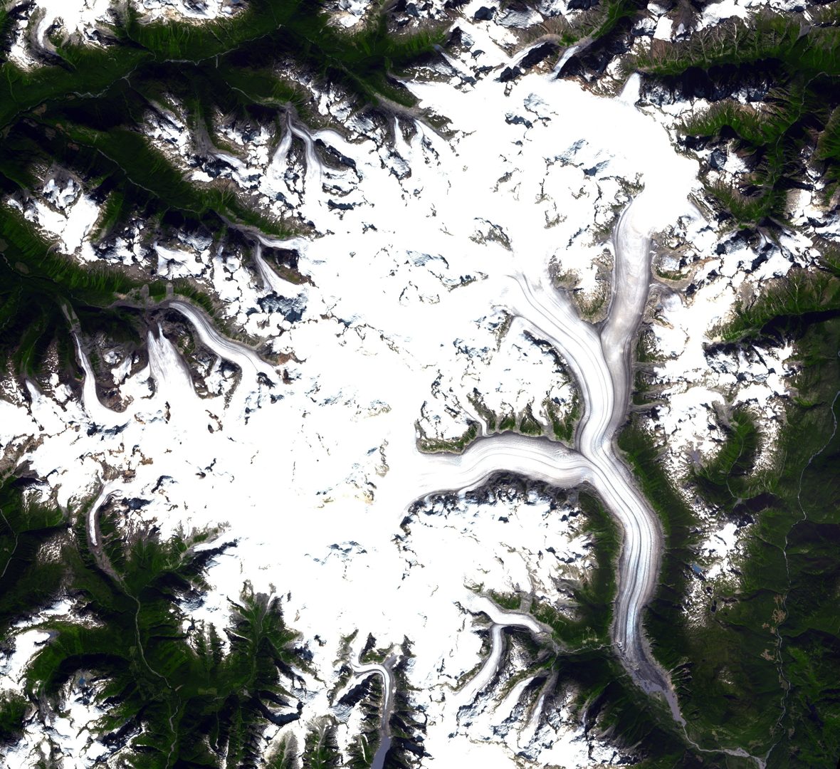
Approaching Mount Silverthrone is to enter a realm of raw, glacial wilderness where the vast Ha-Iltzuk Icefield dominates the landscape. The trek immerses you in a dramatic volcanic caldera, cloaked beneath ancient ice and snow. The silence is profound, broken only by the crunch of crampons on ice and the distant roar of glaciers calving. The stark contrast between the icy expanses and rugged volcanic domes evokes a powerful sense of Earth’s primal forces. Reaching the summit ridge, climbers are rewarded with sweeping views over one of Canada’s most remote and largest volcanic calderas, a humbling reminder of geological time and power.
The Volcano Itself: Geological Background
Mount Silverthrone is an eroded lava dome situated on the northeastern edge of the Silverthrone Caldera, a vast volcanic complex approximately 20 kilometers in diameter. This caldera is one of the few in western Canada buried beneath thick glacial ice, part of the extensive Ha-Iltzuk Icefield. The volcanic rocks include rhyolites, dacites, and andesites, with some lava flows dated between 750,000 and 400,000 years old. Younger volcanic activity, including lava flows and pyroclastic cones, is believed to be less than 13,000 years old, indicating relatively recent volcanism in geological terms. The caldera lies within the Coast Plutonic Complex, the largest contiguous granite outcropping worldwide, and the terrain is heavily glaciated, shaped by both volcanic and glacial processes. Despite its dormancy, the volcano’s eruptive history remains poorly studied due to its remote location and ice cover.
The Volcano Trek: Terrain and Hiking Experience
Trekking Mount Silverthrone is a demanding expedition that challenges even experienced mountaineers. The terrain is dominated by the Ha-Iltzuk Icefield, the largest icefield in the Coast Mountains south of Alaska, featuring vast expanses of glacial ice, crevasses, and snowfields. Climbers must navigate steep glacier slopes, icefalls, and rugged volcanic rock outcrops. The ascent typically involves technical glacier travel requiring crampons, ice axes, and rope teams to safely cross crevassed areas. The volcanic terrain beneath the ice includes eroded lava domes and steep ridges, adding to the complexity. Weather conditions can be harsh and unpredictable, with temperatures often below freezing and strong winds near the summit. Altitude effects are moderate but combined with technical glacier travel, they increase the physical and mental demands. The approach usually begins with a ski or hike from remote landing zones on the icefield, often accessed by air from Tatla Lake. The remoteness means no established trails or fixed camps, requiring self-sufficiency and careful route finding. The descent can be equally challenging, with loose volcanic scree and icy slopes demanding careful footing. Overall, the trek offers a unique blend of volcanic geology and glacial mountaineering in a pristine wilderness setting.
What Makes This Volcano Trek Unique
Mount Silverthrone stands out as Canada’s largest volcanic caldera, hidden beneath one of the most extensive icefields in the southern Coast Mountains. Its combination of volcanic and glacial landscapes is rare, offering a dramatic contrast between ice-covered domes and rugged volcanic rock. The volcano’s remote location ensures solitude and a true wilderness experience, far from developed trails or tourist infrastructure. The presence of young lava flows beneath the ice and the caldera’s size make it a geological marvel. Skiable slopes descending thousands of meters towards the Pacific Ocean add to the adventure, attracting expert ski mountaineers. The historical first ascent by pioneering climbers Don and Phyllis Munday adds a rich mountaineering heritage to the site. This trek is a unique expedition blending technical glacier travel, volcanic exploration, and remote wilderness adventure.
The Summit and Crater Experience
Reaching the summit ridge of Mount Silverthrone reveals a breathtaking panorama of the Ha-Iltzuk Icefield and the vast caldera below. The summit is a glaciated ridge with views extending over rugged volcanic peaks and sweeping icefields. The crater itself is largely obscured by ice, but the volcanic origins are evident in the surrounding rock formations and lava domes. Climbers can sense the immense geological forces that shaped this landscape, with the cold air carrying faint traces of sulfur and the distant sounds of shifting ice. The summit experience is both humbling and exhilarating, offering a rare glimpse into a remote volcanic wilderness rarely visited by humans.
Best Time to Trek Mount Silverthrone
The optimal trekking season for Mount Silverthrone is during the summer months from July to September when weather conditions are relatively stable and temperatures are milder. Snow and ice conditions are more manageable, and daylight hours are extended. However, even in summer, sudden weather changes can occur, including snowstorms and high winds. Winter and shoulder seasons are generally not recommended due to extreme cold, avalanche risk, and limited accessibility. Climbers should monitor weather forecasts closely and be prepared for freeze-thaw cycles. Access by air is also more feasible in summer, as landing on the icefield requires stable weather and good visibility.
Trekking Routes and Trail Options
Mount Silverthrone’s remoteness means there are no established hiking trails or commercial routes. Access is primarily by air, with ski planes landing on the Ha-Iltzuk Icefield near the Klinaklini or Silverthrone Glaciers. From these landing zones, climbers embark on glacier travel and mountaineering routes to the summit. The most commonly used ascent route is the broad glaciated northeast ridge, which offers a gradual skin or walk to the summit with a steep final section to the summit ridge. This route requires technical glacier travel skills, including crevasse navigation and rope team techniques. Alternative approaches involve lengthy ski or hike-in from logging camps at Owikeno Lake or Knight Inlet, but these are arduous and rarely attempted. Due to the lack of marked trails, route finding is critical, and expeditions must be self-supported with careful planning. Guided expeditions are rare, and most climbers are experienced mountaineers familiar with glacier travel and remote wilderness logistics.
Difficulty Assessment
Mount Silverthrone is classified as a technical mountaineering ascent requiring advanced skills in glacier travel, crevasse rescue, and alpine navigation. The terrain includes steep ice slopes, crevassed glaciers, and rugged volcanic ridges. Climbers must be proficient with crampons, ice axes, and rope techniques. The altitude, while moderate at 2864 meters, combined with the technical terrain and remote location, increases the overall challenge. Physical fitness, experience in cold weather mountaineering, and expedition planning are essential. This trek is not suitable for beginners or casual hikers and demands careful preparation and respect for the mountain’s hazards.
Essential Volcano Trekking Gear
Key gear for Mount Silverthrone includes mountaineering boots compatible with crampons, technical crampons, ice axes, climbing harness, ropes, and crevasse rescue equipment. Layered clothing suitable for cold, wet, and windy conditions is essential, including waterproof outer layers and insulated mid-layers. Glacier travel requires helmets, carabiners, prusiks, and snow anchors. Trekking poles assist on mixed terrain. A GPS device and topographic maps are critical for navigation in this unmarked terrain. Additional essentials include a reliable stove for melting snow, high-calorie food, a first aid kit, and emergency communication devices such as satellite phones or PLBs. Sun protection is necessary due to high UV exposure on snow and ice.
Safety and Volcanic Hazards
Mount Silverthrone’s primary hazards stem from its glaciated terrain rather than active volcanism, as it is classified dormant. Risks include crevasse falls, avalanches, unstable ice, and sudden weather changes. The remoteness complicates rescue operations, so self-sufficiency and thorough risk management are vital. Although minor seismic activity has been recorded, no recent eruptions are known. Climbers should monitor volcanic activity reports from the Geological Survey of Canada and heed any warnings. Proper training in glacier travel, crevasse rescue, and avalanche awareness is mandatory. Due to the icefield’s complexity, parties should travel roped together and carry appropriate safety equipment. Weather can deteriorate rapidly, increasing hypothermia risk, so preparedness for emergencies is critical.
Permits, Guides, and Logistics
Access to Mount Silverthrone is highly restricted due to its remote location within protected wilderness areas and the technical nature of the terrain. There are no commercial tour operators offering regular guided trips to Silverthrone, and permits are required for air travel to the Ha-Iltzuk Icefield, typically coordinated through local aviation services based in Tatla Lake or nearby communities. These permits regulate landings on the icefield to minimize environmental impact and ensure safety. Climbers must arrange their own logistics, including charter flights, equipment transport, and emergency plans. Due to the absence of established base camps or infrastructure, expeditions must be fully self-supported and prepared for extended stays in harsh conditions. Communication with the British Columbia Parks and local authorities is essential to obtain necessary permissions and to register expedition plans. The lack of commercial guiding services means that only highly experienced mountaineers with glacier travel expertise should attempt this climb. Weather windows for air access are limited, requiring flexible scheduling and contingency plans. There are no nearby rescue services, so climbers must carry satellite communication devices and emergency supplies.
Where to Stay and Nearby Bases
Due to Mount Silverthrone’s extreme remoteness and lack of tourism infrastructure, there are no accommodations or established base camps near the volcano. The closest settlement is the small rural community of Tatla Lake, approximately 120 kilometers southeast, which serves as the primary staging point for air access to the Ha-Iltzuk Icefield. Tatla Lake offers limited lodging options such as small inns and guesthouses catering to local travelers and pilots. For climbers, overnight stays here are typically brief before charter flights to the icefield. Beyond Tatla Lake, the region is wilderness with no roads, lodges, or services. Expeditions must be fully self-sufficient, carrying all camping gear and supplies for glacier camping on the icefield. Due to the absence of nearby accommodations, thorough preparation and logistical planning are critical. The nearest developed mountain lodges, such as those in the Canadian Rockies (e.g., Cathedral Mountain Lodge), are several hundred kilometers away and not practical for Silverthrone expeditions. Climbers should plan to camp on the icefield or glaciers using expedition-style tents and equipment designed for extreme alpine conditions.