
Trekking Peteroa Volcano: A Demanding Adventure on Chile’s Active Complex Volcano
Explore the challenging ascent of Peteroa Volcano, a complex and active volcanic structure in Chile’s Maule region. This guide covers geological insights, trekking routes, safety tips, permits, accommodations, and what makes this volcano a unique destination for adventurous hikers and geology enthusiasts.
Quick Volcano Snapshot
| Attribute | Value |
|---|---|
| Volcano type | Complex volcano |
| Elevation | 3603 m |
| Location | Maule Region, Chile |
| Activity status | Active |
| Trekking difficulty | Demanding |
| Typical trek duration | 6 to 8 hours |
| Altitude gain | Approximately 1,100 m |
| Terrain type | Volcanic ash slopes, lava rock, sulfuric acid crater floors |
| Best season | January to April |
| Temperature range | -5°C to 15°C |
| Permit requirement | Required; border crossing formalities apply |
The Experience of Hiking Peteroa Volcano
Approaching Peteroa Volcano, hikers are immediately struck by the raw, rugged volcanic landscape that stretches across the Maule region. The terrain is a dramatic contrast of barren lava fields and steaming fumaroles, punctuated by sulfuric acid lakes nestled within the craters. The air carries a faint scent of sulfur, a reminder of the volcano’s active nature. As you ascend, the panorama unfolds to reveal mighty glaciers on neighboring Cerro Azufre and a mountain vista reminiscent of the Himalayas. Reaching the crater edge, the earth steams and bubbles beneath your feet, offering a visceral connection to the geological forces shaping this complex volcano. The climb is demanding but rewarding, immersing trekkers in a landscape where nature’s power is palpable and ever-present.
Geological Background of Peteroa Volcano
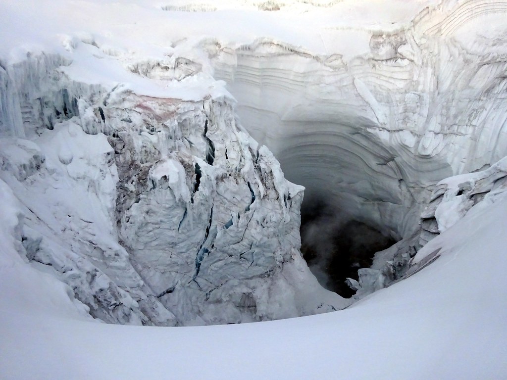
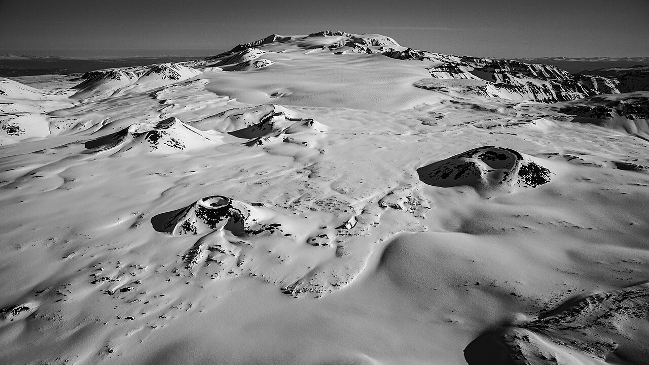
Peteroa is a complex volcano situated along the border between Chile and Argentina, part of the larger Planchón-Peteroa volcanic complex. This structure comprises multiple overlapping calderas and volcanic edifices formed over thousands of years. Approximately 11,500 years ago, a significant partial collapse of the complex triggered a massive debris avalanche that shaped the surrounding landscape, following the course of the Teno River into Chile’s Central Valley. The volcano features several craters, including one with a sulfuric acid lake, indicative of ongoing fumarolic activity. Its geology is marked by layers of lava flows, ash deposits, and volcanic minerals such as sulfur, which accumulate around fumaroles and steam vents. The active fumarolic fields and steaming vents provide a vivid display of the volcano’s internal heat and ongoing volcanic processes, making Peteroa a fascinating subject for both geologists and adventurous trekkers.
Terrain and Hiking Experience on Peteroa Volcano
The trek up Peteroa Volcano presents a demanding challenge characterized by diverse volcanic terrain and variable conditions. Starting from the base, hikers traverse volcanic ash slopes that can be loose and slippery, requiring careful footing and steady balance. The ascent involves navigating over rugged lava rock formations that demand occasional scrambling, testing both agility and endurance. As the trail climbs above 2,400 meters, trekkers encounter views of the glaciers on Cerro Azufre, adding a stark contrast of ice against the volcanic landscape. Near 3,000 meters, the sulfur fumes become noticeable, carried by the wind and signaling proximity to active fumarolic zones. The final approach to the caldera rim at approximately 3,500 meters involves steep sections where the trail is exposed to strong winds and sudden temperature drops. Upon reaching the crater edge, hikers descend into the caldera floor, where two large craters dominate the scene. One crater contains a sulfuric acid lake about 150 meters in diameter, surrounded by steaming and boiling earth. This area requires caution due to the risk of burns from hot steam vents and unstable ground. The terrain here is a mix of soft volcanic ash, rocky outcrops, and fumarolic fields, creating a unique but challenging hiking environment. The return journey typically takes around 2.5 hours, descending over loose scree and ash slopes that allow for controlled sliding, providing a thrilling end to the trek. Overall, the hike demands good physical fitness, proper equipment, and respect for the active volcanic hazards present throughout the route.
What Makes the Peteroa Volcano Trek Unique
Peteroa Volcano stands out due to its complex volcanic structure featuring multiple overlapping calderas and active fumarolic activity. The presence of sulfuric acid lakes within the craters adds a rare and striking element to the landscape. Unlike many volcanoes, Peteroa offers a combination of volcanic heat, glacial ice on nearby peaks, and expansive mountain panoramas reminiscent of the Himalayas. The steaming fumaroles and boiling earth inside the caldera provide a direct sensory experience of volcanic power. Additionally, the volcano’s location at the Chile-Argentina border introduces a cross-cultural trekking experience, with access routes from both countries. The relatively less crowded trails compared to more famous volcanoes allow for a more intimate and adventurous exploration. The interplay of volcanic gases, acid lakes, glaciers, and rugged terrain creates a dynamic environment that is both scientifically intriguing and visually spectacular.
The Summit and Crater Experience at Peteroa
Reaching the summit rim of Peteroa Volcano is a moment of awe and exhilaration. From the caldera edge, hikers are rewarded with sweeping views of the surrounding Andes mountains and the neighboring glaciers of Cerro Azufre. The crater itself is a dramatic scene: one of the large craters contains a vivid sulfuric acid lake, its surface shimmering with yellow and green hues from mineral deposits. The ground around the crater steams vigorously, releasing hot gases and creating a faint hissing sound as fumaroles vent beneath the earth. The air is tinged with the sharp scent of sulfur, and the heat radiating from the vents contrasts with the cool mountain air. The experience is both humbling and thrilling, offering a rare glimpse into the Earth’s volcanic heart. Caution is essential here, as the ground can be unstable and steam vents dangerously hot. The panoramic vistas and the sensory intensity of the crater environment make this summit experience unforgettable.
Best Time to Trek Peteroa Volcano
The optimal trekking season for Peteroa Volcano spans from January through April, when weather conditions are generally stable and snow cover is minimal. During these months, temperatures range from mild to cool, typically between -5°C and 15°C, allowing for safer and more comfortable hiking. Outside this window, winter months bring heavy snow and ice, increasing the difficulty and hazards of the ascent. Additionally, volcanic activity can fluctuate, so it is essential to monitor updates from Chilean volcanic authorities such as SERNAGEOMIN. Climbers should avoid periods of heightened seismic activity or ash emissions, which can pose serious risks. Early morning starts are recommended to take advantage of calmer winds and clearer skies. Seasonal considerations also include the potential for sudden weather changes and strong winds near the summit, so trekkers must be prepared for variable conditions year-round.
Trekking Routes and Trail Options for Peteroa Volcano
The primary access route to Peteroa Volcano begins from the Chilean side, typically starting near the town of Curicó. From there, trekkers take the Vergara Pass road toward the Argentine border. The last accommodation and supply point is in Los Queñes, approximately 31 kilometers from the trailhead. The road beyond this point deteriorates, leading to the Chilean border post at San Pedro, where official exit procedures are required. The ascent itself is usually approached from the Argentine side near Malargüe, offering a 15.9 km mountain hike with an elevation gain of about 1,128 meters. This route takes approximately 6 hours to reach the summit rim. The trail is well-marked and passes through diverse volcanic terrain, including ash slopes and lava rock fields. Guided tours are available through operators such as Costa y Cumbre Tours based in Talca and Tralka Road SpA, which provide logistical support, local knowledge, and safety guidance. These tours often include transportation, permits, and experienced guides familiar with the volcanic hazards. Self-guided options exist but require careful planning, proper permits, and awareness of border crossing regulations. Alternative routes may involve traversing nearby volcanic peaks like Planchón or Cerro Azufre, but these are more technically demanding and less frequented.
Difficulty Assessment of the Peteroa Volcano Trek
Peteroa Volcano presents a demanding trekking challenge that combines moderate technical difficulty with significant stamina requirements. The terrain includes steep volcanic ash slopes that can be slippery and unstable, requiring good balance and sure-footedness. Sections of lava rock scrambling add a technical element, though no specialized climbing equipment is generally necessary. The altitude, reaching over 3,600 meters, introduces potential effects such as reduced oxygen levels and increased fatigue, making acclimatization advisable. Weather conditions near the summit can be harsh, with strong winds and rapid temperature changes. Overall, the trek is classified as a demanding volcano ascent, suitable for experienced hikers with good physical fitness and some prior high-altitude trekking experience. Beginners should consider guided tours and proper preparation before attempting the climb.
Essential Gear for Trekking Peteroa Volcano
Successful trekking on Peteroa Volcano requires specialized gear to handle volcanic terrain and variable weather. Recommended equipment includes sturdy hiking boots with excellent grip for loose ash and rocky surfaces, and trekking poles to aid balance on steep slopes. Volcanic ash gaiters help protect against fine ash and debris. A windproof and waterproof jacket is essential to guard against sudden weather changes and cold temperatures at altitude. Due to active fumarolic gases, carrying a gas mask or respirator is advisable to protect against sulfur dioxide and other volcanic emissions. A headlamp is useful for early morning starts or late returns. Hydration systems are critical, as volcanic landscapes offer little shade and can be dehydrating. Sun protection, including high-SPF sunscreen, sunglasses, and a wide-brimmed hat, is necessary to prevent sunburn at high elevation. Additionally, layered clothing allows for temperature regulation during the ascent and descent.
Safety and Volcanic Hazards on Peteroa Volcano
Trekking Peteroa Volcano involves inherent risks due to its active volcanic status and challenging terrain. Volcanic gases such as sulfur dioxide and hydrogen sulfide are emitted from fumaroles and vents, posing respiratory hazards; hikers should carry gas masks and avoid prolonged exposure near vents. The crater edges can be unstable and prone to collapse, requiring caution when approaching. Loose scree and volcanic ash slopes increase the risk of slips and falls, especially during descent. Sudden eruptions or explosions, although infrequent, can occur without warning, underscoring the importance of monitoring alerts from Chile’s SERNAGEOMIN volcanic observatory. Falling rocks and debris avalanches are additional hazards in steep areas. Weather conditions can change rapidly, bringing strong winds, cold temperatures, and reduced visibility. It is essential to hike with experienced guides, carry communication devices, and adhere strictly to safety regulations and official warnings. Emergency plans and knowledge of evacuation routes are critical for safe trekking.
Permits, Guides, and Logistics for Peteroa Volcano Trekking
Trekking Peteroa Volcano requires careful logistical planning, including obtaining necessary permits and coordinating with local authorities. The volcano lies on the Chile-Argentina border, so hikers must comply with border crossing regulations, including official exit and entry procedures at the San Pedro Chilean border post. Permits are required to access the volcanic area, and these can be arranged through local tourism offices or tour operators. Costa y Cumbre Tours, based in Talca, and Tralka Road SpA are reputable companies offering guided tours that include permit processing, transportation, and expert guidance. These operators provide valuable support navigating the complex terrain and volcanic hazards, enhancing safety and the overall experience. Permit costs vary but generally include park entry fees and border crossing charges. It is important to note that food purchased in Chile cannot be brought back across the border, so provisioning should be planned accordingly. Access roads deteriorate beyond Los Queñes, the last major settlement offering accommodation and supplies, making guided transport advisable. Seasonal volcanic activity may lead to temporary trail closures or restrictions, so checking current conditions with SERNAGEOMIN and local authorities before the trek is essential. Overall, engaging a professional guide service is highly recommended for this demanding and active volcano.
Where to Stay and Nearby Bases for Peteroa Volcano
The primary base for trekking Peteroa Volcano is the town of Los Queñes in Chile’s Maule region. Los Queñes offers the last reliable accommodation and provisioning point before the ascent. A recommended lodging option is Hostería Los Queñes, which provides comfortable rooms, meals, and local hospitality. Staying here allows trekkers to acclimatize and prepare for the demanding climb ahead. The town is equipped with basic amenities including food supplies, which are essential since no provisions are available beyond this point. From Los Queñes, the trailhead is approximately 31 kilometers away, accessible via the Vergara Pass road, although the road conditions worsen significantly past the cement mine intersection. Due to the remote and rugged nature of the area, many trekkers opt to arrange guided transport from Los Queñes to the trail start. On the Argentine side, Malargüe serves as a gateway for the ascent, offering additional accommodation and services for trekkers. However, access from Argentina involves border crossing formalities. Given the active volcanic environment and limited infrastructure, camping near the volcano is generally not recommended without proper permits and guidance. For those seeking more amenities, nearby larger towns such as Curicó and Talca provide a wider range of hotels and services, though they are farther from the trailhead. Overall, Los Queñes remains the most practical and convenient base for Peteroa Volcano expeditions.