

Mount Azuma Volcano Trekking Guide: Exploring Japan’s Active Complex Volcano in Tohoku
Mount Azuma, an active complex volcano in Japan’s Tohoku region, offers a captivating trekking experience with its volcanic craters, fumaroles, and scenic landscapes. This guide covers the geological background, detailed hiking terrain, routes, safety tips, permits, and accommodation options for adventurers seeking to explore this unique volcanic landscape.
Quick Volcano Snapshot
| Attribute | Value |
|---|---|
| Volcano type | Complex volcano |
| Elevation | 2035 meters |
| Location | Tohoku, Japan |
| Activity status | Active |
| Trekking difficulty | Moderate |
| Typical trek duration | 1 to 4 hours for main trails; multi-day options available |
| Altitude gain | Up to 500 meters on main routes |
| Terrain type | Loose volcanic sand, gravel, scoria, marshlands, rocky ridges |
| Best season | Late April to mid November (road closed mid November to mid April) |
| Temperature range | 5°C to 20°C during hiking season |
| Permit requirement | No special permits required; park entry fees may apply |
Introduction: The Experience of Hiking Mount Azuma
Approaching Mount Azuma, hikers are greeted by a striking volcanic landscape crowned by Azuma-Kofuji, a perfectly shaped miniature volcano reminiscent of Mount Fuji. The terrain shifts from barren volcanic slopes to vibrant marshlands dotted with wildflowers, creating a vivid contrast. The air carries the faint scent of sulfur from fumaroles, hinting at the mountain’s active nature. Trekking here is an immersive journey into geological power, where every step reveals the dynamic forces shaping the earth. Reaching the crater rim offers panoramic views of emerald volcanic lakes and rugged peaks, evoking a profound sense of awe and connection to nature’s raw energy.
The Volcano Itself: Geological Background
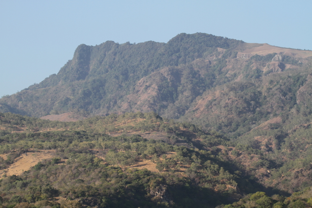
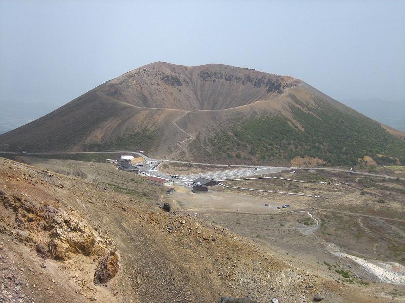
Mount Azuma is a complex volcano located in the Tohoku region of Japan, rising to an elevation of 2035 meters. It formed through multiple eruptive phases that created overlapping volcanic cones and craters. The most iconic feature is Azuma-Kofuji, a symmetrical cinder cone resembling a smaller Mount Fuji, formed from relatively recent volcanic activity. The volcano’s landscape is marked by fumaroles emitting volcanic gases, sulfur deposits, and steaming vents that reveal ongoing subterranean activity. Lava flows and ash deposits have shaped the surrounding terrain, creating a mosaic of volcanic minerals and rugged rock formations. The presence of marshlands and ponds within the volcanic caldera adds ecological diversity to this dynamic geological environment.
The Volcano Trek: Terrain and Hiking Experience
Hiking Mount Azuma offers a diverse and engaging terrain that challenges and delights trekkers. The ascent to Azuma-Kofuji involves climbing loose volcanic sand, gravel, and scoria, which can be slippery and requires careful footing. The trail is well-maintained but demands moderate fitness due to steep sections and uneven surfaces. As hikers progress, they encounter rocky ridges and exposed crater rims where wind conditions can be strong, adding an element of exposure and requiring caution. The volcanic ash slopes contrast with lush marshlands and grasslands in the Jododaira area, where hikers can observe unique alpine flora thriving in the nutrient-poor volcanic soil. The trail network is extensive, offering options from short crater rim walks to longer ridge traverses, including the popular route to Mt. Issaikyo and beyond. Altitude effects are mild but noticeable, with temperatures dropping near the summit and weather conditions changing rapidly. The terrain’s volcanic origin means hikers must be prepared for loose scree and occasional fumarole steam vents along the way. Overall, the hiking experience combines geological intrigue with physical challenge, rewarding trekkers with spectacular views of emerald crater lakes, volcanic cones, and the surrounding Bandai-Asahi National Park.
What Makes This Volcano Trek Unique
Mount Azuma stands out for its iconic Azuma-Kofuji cone, a rare example of a perfectly symmetrical cinder cone that invites climbers to circle its crater rim. The presence of active fumaroles and sulfur vents within the crater adds a sensory dimension, with the smell of sulfur and visible steam reminding hikers of the volcano’s living nature. The surrounding landscape features vibrant marshlands and turquoise volcanic lakes such as Goshikinuma, creating a striking palette of colors against the volcanic rock. The Bandai-Azuma-Adatara Volcano Trail connects Mount Azuma with neighboring active volcanoes, offering a multi-day trekking adventure through diverse volcanic terrains. Seasonal wildflowers and alpine plants flourish in the nutrient-poor soils, providing ecological interest alongside geological wonders. The Bandai Azuma Skyline road enhances accessibility, allowing hikers to reach high elevations quickly and enjoy panoramic views of the Tohoku region’s volcanic landscape.
The Summit and Crater Experience
Reaching the summit of Azuma-Kofuji or Mt. Issaikyo offers a dramatic encounter with the volcano’s raw power. At the crater rim, hikers witness steaming fumaroles and sulfur deposits that emit a faint, pungent aroma. The ground beneath is warm in places, evidence of the active magma chamber below. The panoramic views stretch across the Azuma mountain range, revealing emerald crater lakes like Goshikinuma and the rugged peaks of neighboring volcanoes. The sound of escaping volcanic gases punctuates the stillness, while the wind sweeps across the exposed ridges. The vibrant colors of the volcanic landscape, from rust-red scoria to deep green marshes, create a surreal and unforgettable scene. This sensory experience connects trekkers intimately with the earth’s dynamic forces.
Best Time to Trek Mount Azuma
The optimal trekking season for Mount Azuma spans from late April or early May through mid November, when the Bandai Azuma Skyline road is open and weather conditions are favorable. Autumn, particularly early to mid October, is renowned for spectacular fall foliage that enhances the volcanic landscape’s beauty. Winter months bring heavy snow and road closures, making access difficult and unsafe. Spring offers blooming wildflowers but can be wet and muddy. Hikers should monitor volcanic activity alerts, as Mount Azuma is active and subject to sudden changes. Early morning climbs are recommended to avoid afternoon winds and to enjoy clear views. Seasonal hazards include strong winds near the summit, sudden weather shifts, and occasional volcanic gas emissions.
Trekking Routes and Trail Options
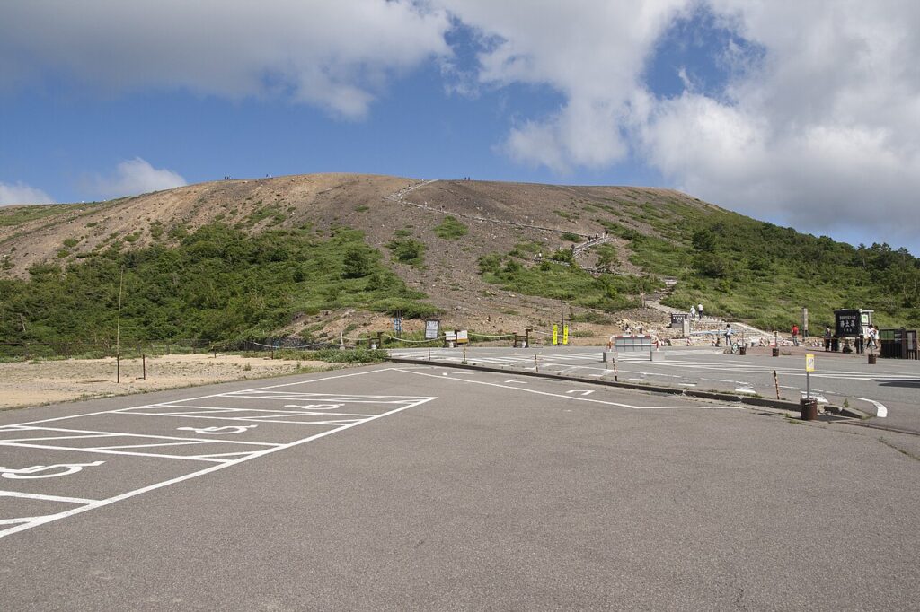
Mount Azuma offers a variety of trekking routes catering to different skill levels and interests. The most popular and accessible trail begins at the Jododaira Visitor Center near the Bandai Azuma Skyline parking lot. From here, hikers can ascend Azuma-Kofuji’s crater in about 10 to 15 minutes, followed by a panoramic 45-minute walk around its rim. For a more challenging hike, the trail to Mt. Issaikyo takes approximately 80 minutes of moderate climbing, rewarding trekkers with expansive views of the volcanic landscape and the emerald Goshikinuma pond. Beyond Issaikyo, the route continues past Kamanuma Pond and ascends Mt. Higashi Azuma, a steeper and more rugged trail that takes about 45 minutes from the pond. Longer multi-day options include traversing the Bandai-Azuma-Adatara Volcano Trail, which connects Mount Azuma with neighboring active volcanoes and volcanic lakes over a 300 km route. This trail can be tackled in sections, with accommodations and hot springs available along the way. Alternative loops around Kamanuma Pond and marshlands offer gentler terrain suitable for day hikes. Trails are well-marked, and maps are available at the visitor center. Guided tours are offered by local operators for those seeking expert insights and logistical support.
Difficulty Assessment
Mount Azuma’s trekking difficulty is classified as moderate. The terrain includes loose volcanic sand, gravel, and scoria that can be slippery, requiring good balance and sturdy footwear. Elevation gain on main routes ranges up to 500 meters, with some steep sections especially on the ascent to Mt. Issaikyo and Mt. Higashi Azuma. The trails are non-technical but demand a reasonable level of fitness and endurance. Altitude effects are mild but can cause slight breathlessness near the summit. Weather conditions, including strong winds and sudden temperature drops, add to the challenge. The volcanic environment requires hikers to be cautious of unstable ground near fumaroles and crater edges. Overall, the trek is suitable for hikers with some mountain experience and good physical condition, but beginners can enjoy shorter, easier routes such as the Azuma-Kofuji crater walk.
Essential Volcano Trekking Gear
For trekking Mount Azuma, essential gear includes sturdy hiking boots with good grip to navigate loose volcanic sand and rocky terrain. Trekking poles are recommended to aid balance on slippery slopes. A windproof and waterproof jacket is necessary due to variable weather and strong winds near the summit. Layered clothing helps manage temperature changes. Sun protection such as a hat, sunglasses, and sunscreen is important as the volcanic landscape offers little shade. A headlamp is useful for early morning or late afternoon hikes. Carry sufficient water and snacks, as facilities on the trail are limited. A map or GPS device is advised, along with a basic first aid kit. Although volcanic gas levels are generally low, sensitive individuals may consider a lightweight respirator or mask. Emergency whistle and mobile phone for communication are recommended. Finally, bring a camera to capture the spectacular volcanic scenery.
Safety and Volcanic Hazards
Mount Azuma is an active volcano, and hikers must remain vigilant about volcanic hazards. Fumaroles emit sulfurous gases that can be harmful in high concentrations; avoid lingering near vents and follow all posted warnings. The volcanic alert level system is monitored by local authorities, and access may be restricted during increased activity. Unstable crater edges and loose scree pose risks of falls and rockslides, especially on steep slopes. Sudden weather changes, including strong winds and fog, can reduce visibility and increase exposure risks. It is essential to check volcanic activity updates before hiking and to carry a map indicating evacuation routes and emergency shelters such as the Meigetsusou hut. Wearing a helmet is advisable in areas prone to falling rocks. Hikers should inform someone of their itinerary and expected return time. In case of eruption warnings, follow instructions from park officials promptly. Preparedness and respect for the volcano’s power ensure a safe and rewarding trekking experience.
Permits, Guides, and Logistics
Mount Azuma does not require special permits for hiking, making it accessible for independent trekkers. However, visitors should register at the Jododaira Visitor Center to obtain current volcanic activity information and trail maps. The Bandai-Asahi National Park may charge nominal park entry fees, which contribute to trail maintenance and conservation. Several reputable tour operators provide guided hiking experiences and logistical support, including Tohoku Local Secret Tours, Hike Master Japan, and In Outbound Sendai & Matsushima. These operators offer customizable tours ranging from day hikes to multi-day trekking packages along the Bandai-Azuma-Adatara Volcano Trail, often including luggage transport, accommodation bookings, and expert guidance on volcanic safety and local ecology. Guided tours are recommended for first-time visitors or those unfamiliar with volcanic terrain, ensuring a safer and more informative experience. Access to the trailhead is facilitated by the Bandai Azuma Skyline road, open from mid-April to mid-November, with parking available at Jododaira. Public transport options are limited, so renting a car or joining a tour is advisable. Seasonal road closures and weather conditions should be monitored in advance. Emergency shelters such as Meigetsusou hut are available on longer routes, but hikers must carry their own food and sleeping gear. Overall, logistical planning is straightforward, with ample resources and local expertise to support volcano trekking adventures.
Where to Stay Near Mount Azuma
Accommodation options near Mount Azuma cater to a range of preferences, from traditional ryokans to mountain huts and hot spring inns. The Jododaira area, adjacent to the Bandai Azuma Skyline parking lot, serves as the primary base for accessing the volcano’s trails. Here, the Jododaira Visitor Center provides essential information and trail maps. For mountain hut accommodations, Meigetsusou offers a free emergency shelter with water but requires guests to bring their own food and sleeping bags. For more comfortable lodging, nearby hot spring resorts such as Takayu Onsen and Tsuchiyu Onsen are popular choices, located approximately 30 minutes’ drive from Jododaira. These onsen towns feature public baths, ryokans, and guesthouses where hikers can relax after trekking. Notable ryokans include Futamata Onsen Kashiwaya Ryokan, renowned for its five natural hot springs, self-flowing stone baths, and traditional Japanese hospitality. Amenities often include Wi-Fi, meals featuring local Fukushima cuisine, and guided nature walks. For those seeking convenience, accommodations in Fukushima City provide urban comforts and easy access to the Bandai Azuma Skyline by car or bus. Camping is also possible in designated areas within Bandai-Asahi National Park, offering a more immersive outdoor experience. Early booking is recommended during peak seasons, especially autumn foliage months. Overall, the region offers a blend of rustic mountain lodging and soothing hot springs, enhancing the volcano trekking adventure.