
Hiking La Palma Caldera de Taburiente: A Complete Volcano Trekking Guide to Spain’s Majestic Volcanic Caldera
Explore the vast and lush Caldera de Taburiente on La Palma, Spain. This comprehensive guide covers geology, trekking routes, terrain challenges, permits, accommodations, and safety tips for hiking this spectacular volcanic caldera.
Quick Volcano Snapshot
| Attribute | Value |
|---|---|
| Volcano type | Caldera |
| Elevation | Up to 2,426 meters (Roque de los Muchachos nearby) |
| Location | La Palma, Canary Islands, Spain |
| Activity status | Dormant |
| Trekking difficulty | Moderate to Demanding |
| Typical trek duration | 6 to 8 hours |
| Altitude gain | Up to 1,000 meters depending on route |
| Terrain type | Volcanic rock, forest trails, ravines, waterfalls |
| Best season | Spring and Autumn |
| Temperature range | 10°C to 25°C |
| Permit requirement | Parking permit required at La Cumbrecita; National Park entry regulated |
Introduction: The Experience of Hiking La Palma Caldera de Taburiente
Approaching the Caldera de Taburiente is like stepping into a colossal natural amphitheater carved by volcanic forces and water erosion. Towering cliffs rise dramatically, enclosing a lush basin filled with Canary Island pines and cascading waterfalls. The air is fragrant with pine and fresh mountain streams, while the silence is punctuated by the calls of native birds. Hiking here immerses you in a landscape where geological power meets vibrant life, offering a profound connection to the island’s volcanic heart. The descent into the caldera reveals a contrast between rugged volcanic rock and verdant forest, culminating in the emotional arrival at the crater floor, a place of serene beauty and raw earth energy.
The Volcano Itself: Geological Background
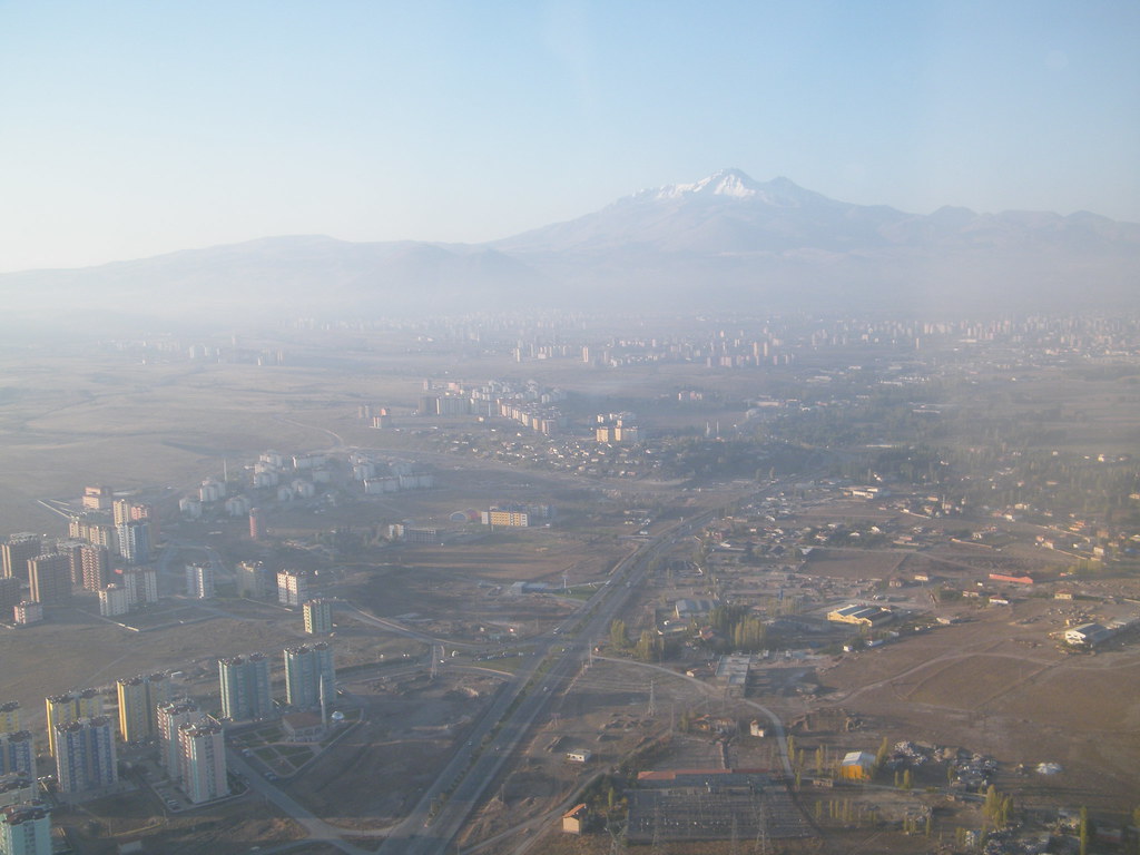
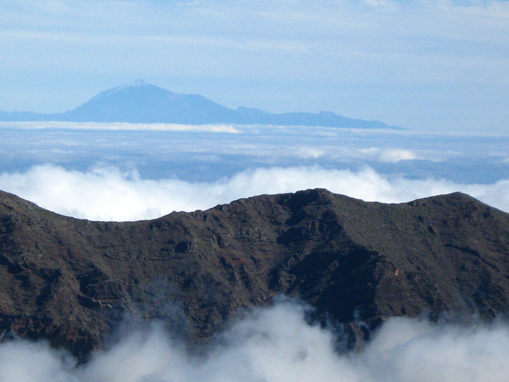
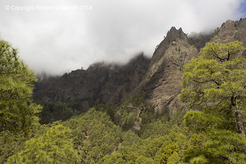
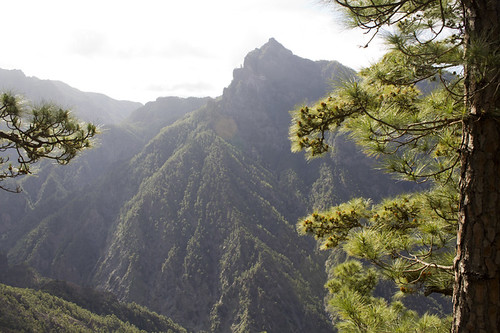
La Palma’s Caldera de Taburiente is a massive erosion caldera formed over millions of years through a combination of volcanic activity, landslides, and intense water erosion. Unlike a typical explosive crater, this caldera spans approximately 8 kilometers in diameter and plunges nearly 1,800 meters deep, surrounded by cliffs soaring up to 2,000 meters. The geology is dominated by basaltic lava flows rich in minerals like olivine and pyroxene, with visible pillow lavas from ancient underwater eruptions. The caldera’s formation involved overlapping eruptions and giant landslides, creating a horseshoe-shaped basin open to the sea via the Barranco de las Angustias. This unique geological history has sculpted a landscape of steep ridges, deep ravines, and abundant watercourses, making it a natural laboratory for volcanic and erosion processes.
The Volcano Trek: Terrain and Hiking Experience
Hiking the Caldera de Taburiente is a demanding yet rewarding experience that challenges both body and senses. The terrain varies from well-maintained forest trails to rugged volcanic rock paths, with sections of steep descents and ascents. Starting typically from the Mirador de Los Brecitos at around 1,080 meters elevation, the trail descends gently through dense Canary pine forests, crossing wooden bridges over streams and passing through lush ravines. The path is often shaded, but exposed sections near the caldera rim can be windy and cooler. As you approach the caldera floor, the trail becomes rockier with loose volcanic stones and occasional slippery moss-covered rocks near waterfalls. The Barranco de las Angustias gorge presents a dramatic landscape of basalt layers, pillow lavas, and crystal-clear pools, requiring careful footing on uneven ground. Altitude effects are moderate but noticeable, especially on longer routes that involve significant elevation changes. Temperature can vary from cool in shaded forested areas to warm in exposed volcanic zones, so layered clothing is essential. The hike demands good physical fitness due to its length, elevation gain, and varied terrain, but the diverse landscapes—from fragrant pine woods to vibrant waterfalls and volcanic rock formations—make every step memorable. Trekkers should be prepared for changing weather and carry sufficient water, as natural sources are limited to certain areas. The trail’s natural beauty, combined with geological wonders, creates an immersive experience that connects hikers deeply with the volcanic environment.

What Makes This Volcano Trek Unique
The Caldera de Taburiente trek stands out for its immense scale and ecological diversity within a volcanic setting. Unlike many volcanic hikes that focus on barren lava fields, this caldera hosts lush Canary pine forests, abundant freshwater streams, and spectacular waterfalls such as the Cascada de Colores, known for its vibrant mineral-rich hues. The caldera’s vast horseshoe shape, with cliffs towering up to 2,000 meters, offers dramatic vistas and a sense of enclosure rare among volcanic landscapes. The presence of permanent watercourses inside the caldera creates a unique microclimate supporting diverse flora and fauna, contrasting sharply with the surrounding arid volcanic slopes. The sacred Roque Idafe rock formation adds cultural significance, while the opportunity to swim in the crystal-clear Taburiente River enhances the trekking experience. This blend of geological grandeur, ecological richness, and cultural heritage makes the Caldera de Taburiente a singular destination for volcano hikers.
The Summit and Crater Experience
Reaching the floor of the Caldera de Taburiente feels like entering a hidden world carved by time. The panoramic views from the rim reveal a vast volcanic amphitheater surrounded by jagged peaks and deep ravines. At the crater floor, the sound of flowing water and bird calls replaces the wind’s howl from above. The air carries the fresh scent of pine and moist earth, while the sight of waterfalls cascading over colorful mineral-streaked rocks captivates the senses. The iconic Roque Idafe stands as a silent sentinel, its silhouette etched against the sky. The experience is both humbling and exhilarating, offering a profound connection to the island’s volcanic origins and natural beauty. Unlike active volcano summits, here the calm and lush environment invites reflection and awe at the forces that shaped this extraordinary landscape.
Best Time to Trek This Volcano
The ideal seasons for trekking the Caldera de Taburiente are spring and autumn when temperatures are mild, ranging from 10°C to 25°C, and rainfall is moderate. These seasons offer comfortable hiking conditions with blooming native flowers adding color and fragrance to the trails. Summer can be warmer and drier, increasing the risk of dehydration and sun exposure, while winter brings cooler temperatures and occasional rain, which can make some paths slippery. It is essential to check weather forecasts and park advisories before planning your hike, as sudden weather changes can occur. The National Park regulates access, and parking at popular viewpoints like La Cumbrecita requires advance reservation. Early morning starts are recommended to avoid midday heat and to enjoy the calm atmosphere. Volcanic activity is dormant, so there are no eruption-related restrictions, but hikers should always respect park rules and seasonal closures.
Trekking Routes and Trail Options
The Caldera de Taburiente offers several trekking routes catering to different skill levels and time availability. The most popular is the circular hike starting at the Barranco de las Angustias car park, descending into the caldera and looping back via the Mirador de Los Brecitos. This route covers approximately 20 kilometers and takes 6 to 8 hours, with an elevation gain and loss of around 1,000 meters. It passes through diverse landscapes including pine forests, waterfalls, and volcanic rock formations. For those seeking a shorter option, a taxi service is available from the Barranco de las Angustias car park to the Mirador de Los Brecitos, allowing hikers to descend through the caldera in 3 to 4 hours. The PR LP 13 trail from La Cumbrecita viewpoint offers easier, family-friendly walks with spectacular views but limited access to the caldera floor. Guided tours by operators such as Isla Bonita Tours, Pelago, and Civitatis provide structured experiences with transportation, knowledgeable guides, and insights into the park’s geology and ecology. All routes require good physical condition due to the terrain and length, and hikers should plan logistics carefully, including parking permits and transport options.
Difficulty Assessment
The Caldera de Taburiente trek ranges from moderate to demanding depending on the chosen route. The terrain includes steep descents and ascents, uneven volcanic rock paths, and sections with loose scree and slippery surfaces near water features. Altitude changes of up to 1,000 meters challenge cardiovascular fitness and leg strength. The hike is not technical but requires good balance and endurance. Weather conditions such as wind and rain can increase difficulty. This trek is best suited for experienced hikers or those in good physical condition. Beginners should consider guided tours or shorter routes with less elevation change. Overall, the trek is classified as a demanding volcano ascent, offering a rewarding experience for prepared adventurers.
Essential Volcano Trekking Gear
For hiking the Caldera de Taburiente, essential gear includes sturdy hiking boots with good grip for rocky and uneven terrain, trekking poles to assist with steep descents and ascents, and layered clothing to adapt to temperature changes. A windproof jacket is recommended for exposed sections. Sun protection such as a wide-brimmed hat, sunglasses, and high SPF sunscreen is vital due to limited shade. Carry sufficient water and snacks, as natural water sources are limited and not always accessible. A headlamp is useful for early starts or late finishes. A small first aid kit, insect repellent, and a map or GPS device enhance safety. For swimming in the caldera’s natural pools, bring swimwear and a quick-dry towel. Gas masks or respirators are not necessary as the volcano is dormant and there are no harmful gases.
Safety and Volcanic Hazards
Although the Caldera de Taburiente is dormant with no recent volcanic activity, hikers should remain cautious of natural hazards. Steep and unstable crater edges require careful footing to avoid falls. Loose volcanic scree and slippery rocks near streams and waterfalls increase the risk of slips and injuries. Sudden weather changes, including fog and rain, can reduce visibility and trail safety. Falling rocks are possible in narrow ravines, so avoid lingering in exposed areas. The National Park authorities monitor conditions and provide safety guidelines; hikers must adhere to marked trails and park regulations. Emergency services are accessible but response times may vary due to the remote terrain. It is advisable to hike with a partner or guide, carry a fully charged mobile phone, and inform someone of your itinerary. Respecting the environment and following safety protocols ensures a secure and enjoyable trekking experience.
Permits, Guides, and Logistics
Access to the Caldera de Taburiente National Park is regulated to preserve its delicate ecosystem. Visitors must obtain a parking permit in advance for popular access points such as La Cumbrecita viewpoint, which can be reserved through the official National Parks website. The main trailhead at Barranco de las Angustias has a car park where parking is permitted without advance reservation, but space is limited. Due to the caldera’s rugged terrain, vehicle access inside the park is prohibited; all exploration is on foot. Several reputable tour operators offer guided hiking experiences, including Isla Bonita Tours, Pelago, Civitatis, Musement, and La Palma Transfer & Tours. These companies provide transportation from major towns, knowledgeable multilingual guides, and organized itineraries covering key highlights such as Los Brecitos viewpoint, Cascada de Colores waterfall, and the caldera floor. Guided tours typically last around 6 hours and cost approximately $38 to $50 per person. Booking in advance is recommended due to high demand. For independent hikers, public buses connect to Los Llanos de Aridane, from where taxis or private transfers can reach trailheads. Hikers should prepare for limited facilities inside the park; carrying sufficient water, food, and appropriate gear is essential. Camping within the park is allowed only with a special permit obtained from park authorities, and stays are limited to designated areas and durations. Seasonal weather and park advisories may affect trail accessibility, so checking current conditions before visiting is crucial. Overall, careful planning and adherence to regulations ensure a safe and responsible visit to this volcanic treasure.
Where to Stay Near the Volcano
Accommodation options near the Caldera de Taburiente cater to a range of preferences and budgets, providing convenient bases for exploring the park. The nearby town of Los Llanos de Aridane, approximately 10 kilometers from the Barranco de las Angustias trailhead, offers numerous hotels, guesthouses, and apartments. Notable options include Hotel Taburiente, known for its comfortable rooms and proximity to local amenities, and various eco-lodges nestled in forested areas for a tranquil stay. For those seeking rustic charm, Casas de Tenerra and Casas de Taburiente within the caldera offer a unique experience, though these are limited and often require advance booking. Camping is possible inside the park at designated sites along the Taburiente River, but a permit must be obtained from park authorities. Visitors can also find accommodations in El Paso and Santa Cruz de La Palma, both within a 20-30 minute drive, featuring boutique hotels and traditional Canarian guesthouses. Amenities typically include Wi-Fi, parking, and easy access to restaurants and shops. Many tour operators provide pickup services from these towns, facilitating hassle-free transfers to trailheads. Early reservation is advised, especially during peak hiking seasons, to secure preferred lodging. Staying near the caldera allows hikers to rest well before and after demanding treks, enhancing the overall volcano hiking experience.