
Mount Price Volcano Trekking Guide: Exploring British Columbia’s Dormant Stratovolcano
Mount Price is a dormant stratovolcano in British Columbia’s Garibaldi Provincial Park, offering a challenging moderate trek with stunning volcanic landscapes, lava flow features, and panoramic summit views. This guide covers geology, terrain, routes, safety, permits, and accommodations for adventurous volcano hikers.
Quick Volcano Snapshot
| Attribute | Value |
|---|---|
| Volcano type | Stratovolcano |
| Elevation | 2,049 metres (6,722 feet) |
| Location | Garibaldi Provincial Park, British Columbia, Canada |
| Activity status | Dormant |
| Trekking difficulty | Moderate |
| Typical trek duration | Full day (approx. 8-10 hours) |
| Altitude gain | Approx. 1,500 metres |
| Terrain type | Volcanic scree, lava boulder fields, forest trails, ridgelines |
| Best season | Summer to early fall (July to September) |
| Temperature range | 5°C to 20°C (41°F to 68°F) in summer |
| Permit requirement | Backcountry permit required for camping; day hiking permit recommended |
Introduction: The Experience of Hiking Mount Price
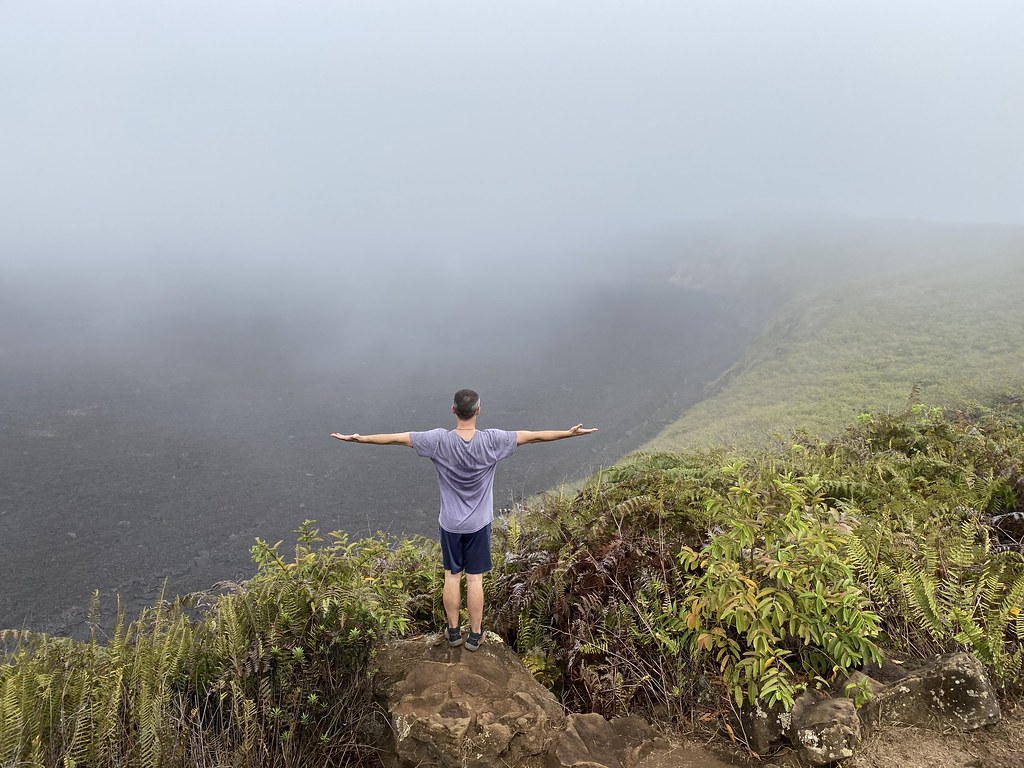
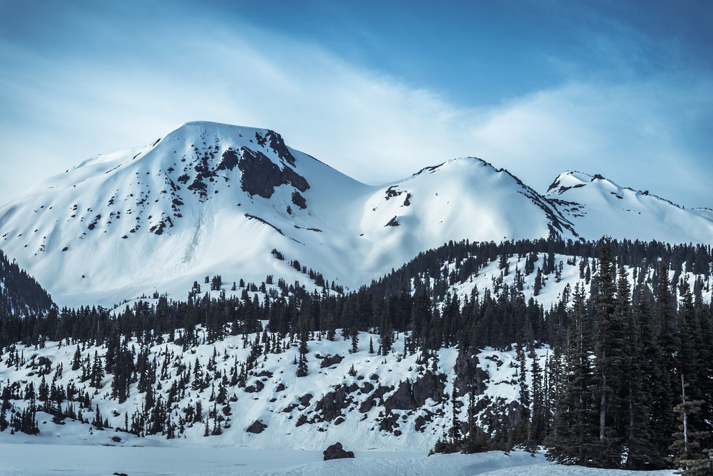
Approaching Mount Price, hikers are greeted by a dramatic volcanic landscape dominated by rugged lava flows and the serene expanse of Garibaldi Lake. The trek begins with a steady ascent through dense forest, gradually revealing glimpses of the mountain’s volcanic cone. As you climb higher, the terrain shifts to volcanic scree and boulder fields, immersing you in the raw geological power that shaped this region. The summit rewards with sweeping panoramic views of the Garibaldi Ranges, including neighboring peaks like Mount Garibaldi and The Black Tusk. The contrast between the lush forests below and the barren volcanic summit creates a profound sense of wilderness and adventure, making the climb a memorable experience for volcano enthusiasts and hikers alike.
Geological Background of Mount Price
Mount Price is a small stratovolcano located within the Garibaldi Volcanic Belt, part of the larger Cascade Arc in southwestern British Columbia. Formed approximately 1.2 million years ago, Mount Price’s volcanic activity continued intermittently until about 15,000 years ago. The volcano’s western flank features Clinker Peak, which produced two significant lava flows that ponded against glacial ice, creating unstable lava dams known as The Barrier. These lava flows have been prone to large landslides, with notable events as recent as the 1850s. The mountain’s geology is characterized by layers of volcanic rock, including basaltic andesite lava flows and pyroclastic deposits. Fumaroles and sulfur deposits are minimal due to its dormant status, but the volcanic features remain prominent, offering hikers a unique glimpse into the region’s volcanic past.
The Volcano Trek: Terrain and Hiking Experience
The trek to Mount Price is a demanding yet rewarding journey that challenges hikers with a variety of volcanic terrains and elevation gains. The hike begins at the Rubble Creek trailhead, where the first 6.5 kilometers consist of steady switchbacks through dense coniferous forest. This section, while monotonous, allows for rapid elevation gain of over 750 meters in about 1.5 hours. Upon reaching the junction near Garibaldi Lake, the trail opens up to more scenic views, including the iconic Barrier lava dam formed by ancient lava flows from Clinker Peak.
From Garibaldi Lake’s western shore, the trail becomes more rugged and volcanic in nature. Hikers traverse a boulder field composed of jagged lava rocks, which requires careful footing and can be particularly challenging if snow is present. Beyond the boulder field, the route ascends a long ridgeline with sporadic trail markers, demanding good navigation skills as the path is faint and overgrown in places. Scrambling through bushes and negotiating uneven volcanic talus, hikers experience the raw volcanic landscape firsthand.
The final ascent to Mount Price’s summit is a gradual climb along an open trail that skirts the base of Clinker Peak. The summit itself is broad and flat, offering expansive 360-degree views of the surrounding Garibaldi Ranges, Garibaldi Lake, and distant coastal mountains. Weather conditions can vary significantly, with strong winds and cooler temperatures at higher elevations. Altitude effects are moderate but noticeable, requiring a steady pace and adequate hydration.
Overall, the terrain combines forest trails, volcanic scree, boulder fields, and ridgeline hiking, making the trek moderately difficult. Hikers should be prepared for route finding challenges, especially beyond Garibaldi Lake, and variable trail conditions depending on the season. The volcanic nature of the terrain provides a unique hiking experience, immersing trekkers in the geological history and raw power of Mount Price.
What Makes the Mount Price Trek Unique
Mount Price stands out among Canadian volcano hikes due to its combination of geological features and scenic vistas. Unlike more frequented peaks, it offers solitude and a sense of wilderness, with fewer hikers on its trails. The presence of Clinker Peak’s ancient lava flows and The Barrier lava dam provides a tangible connection to volcanic processes that shaped the landscape thousands of years ago. The trek’s proximity to Garibaldi Lake adds a striking contrast between vibrant alpine waters and stark volcanic rock.
The summit’s broad, flat volcanic cone is rare in the region and affords panoramic views of the Pacific Ranges, including iconic formations like The Black Tusk and Mount Garibaldi. The challenging boulder fields and ridgeline sections require technical hiking skills, making the trek appealing to experienced adventurers seeking a volcanic landscape that is both rugged and visually spectacular.
The Summit and Crater Experience
Reaching the summit of Mount Price is a moment of awe and reflection. The broad volcanic cone provides unobstructed views across Garibaldi Lake’s shimmering waters and the surrounding peaks of the Garibaldi Ranges. The air is crisp and often carries a faint scent of earth and mineral-rich volcanic soil. Although Mount Price’s crater is not active, the summit’s geological formations reveal the mountain’s fiery past through exposed lava flows and volcanic rock strata.
Hikers can observe the rugged terrain shaped by ancient eruptions and glacial interactions, with the imposing Barrier lava dam visible in the distance. The summit’s open exposure often brings strong winds, adding to the sense of standing on a powerful geological monument. The silence and vastness of the landscape evoke a deep connection to the natural forces that created this dormant volcano.
Best Time to Trek Mount Price
The optimal season for trekking Mount Price is during the summer and early fall months, from July through September. During this period, the weather is generally stable, with mild temperatures ranging from 5°C to 20°C. Snow and ice are minimal, reducing hazards on the volcanic scree and boulder fields. Daylight hours are long, allowing ample time for the full-day trek.
Spring and late fall can present unpredictable weather, including early snowfalls and wet trail conditions, which increase the difficulty and risk. Winter ascents are possible but require advanced mountaineering skills, snowshoes or skis, and avalanche awareness due to snow accumulation and avalanche-prone slopes.
Volcanic activity monitoring is minimal as Mount Price is dormant, but hikers should always check local weather forecasts and park advisories before setting out. Early morning starts are recommended to avoid afternoon weather changes and to maximize daylight.
Trekking Routes and Trail Options
The primary route to Mount Price begins at the Rubble Creek trailhead, located off the Sea to Sky Highway. This trail is approximately 26 kilometers round trip, with an elevation gain of about 1,500 meters. The initial section to Garibaldi Lake is well-traveled and maintained, featuring forested switchbacks and scenic viewpoints such as The Barrier lava dam.
From Garibaldi Lake, hikers follow a less maintained and more rugged trail hugging the lake’s western shore before entering a challenging boulder field formed by lava flows from Clinker Peak. This section requires careful navigation and scrambling over volcanic rocks. Beyond the boulder field, the trail ascends a ridgeline with sporadic markers, demanding good route-finding skills.
An alternative winter route involves ascending directly up one of the northern gullies, often accessed by skiing or snowshoeing across the frozen Garibaldi Lake. This route is more direct but requires avalanche awareness and winter mountaineering experience.
The summit approach continues along an open trail leading to the broad volcanic cone of Mount Price. There are no official side trails or alternate routes to the summit, making the described path the standard and safest option. Guided hikes are uncommon, and most trekkers undertake the route independently, though local guiding services may be available through regional outdoor outfitters.
Difficulty Assessment
Mount Price is classified as a moderate volcano trek. The hike demands good physical fitness due to its length (approximately 26 kilometers round trip) and significant elevation gain of around 1,500 meters. The terrain varies from forest trails to volcanic scree and boulder fields, requiring sure-footedness and some scrambling ability.
While technical climbing equipment is not necessary in summer, hikers should be comfortable with route finding in less marked sections and prepared for variable weather conditions. Altitude effects are moderate but can affect less acclimatized individuals. The trail’s length and ruggedness make it unsuitable for beginners or casual hikers.
In winter, the difficulty increases substantially due to snow, ice, and avalanche risk, elevating the trek to a demanding mountaineering challenge requiring specialized gear and experience.
Essential Volcano Trekking Gear
For a successful Mount Price trek, hikers should equip themselves with sturdy hiking boots offering good ankle support and grip suitable for rocky and scree terrain. Trekking poles are highly recommended to aid balance on uneven volcanic boulders and during the long ascent.
Layered clothing is essential to adapt to temperature changes, including a moisture-wicking base layer, insulating mid-layer, and a windproof, waterproof outer shell. A hat and gloves are advisable, especially for higher elevations where winds can be strong.
Navigation tools such as a detailed map, compass, and GPS device are crucial due to faint trail markings beyond Garibaldi Lake. A headlamp is useful for early starts or late finishes. Carry sufficient water and high-energy snacks, as there are no resupply points on the trail.
Sun protection, including sunglasses, sunscreen, and a wide-brimmed hat, is important given the exposed volcanic terrain. Insect repellent may be needed in forested sections during summer. For winter ascents, additional gear such as snowshoes, crampons, avalanche beacon, probe, and shovel are mandatory.
Safety and Volcanic Hazards
Mount Price is a dormant volcano with no recent eruptive activity, minimizing immediate volcanic hazards. However, the terrain presents natural risks including unstable volcanic scree, loose boulders, and steep ridgelines that require caution and good hiking skills.
The Barrier lava dam near Garibaldi Lake is structurally unstable and designated as a civil defense zone; hikers are advised not to camp or linger in this area. Weather can change rapidly, with strong winds and sudden temperature drops at higher elevations.
Avalanche risk exists in winter and early spring, particularly on slopes and gullies near the summit. Hikers should consult avalanche forecasts and carry appropriate safety equipment during these seasons.
There is limited volcanic monitoring by the Geological Survey of Canada for Mount Price, so hikers should stay informed through BC Parks and local authorities for any advisories. Emergency communication can be limited in remote areas; carrying a satellite messenger or personal locator beacon is recommended for safety.
Permits, Guides, and Logistics
Mount Price lies within Garibaldi Provincial Park, which requires visitors to obtain permits for backcountry camping. Day hiking permits are recommended but not always mandatory; however, it is advisable to check current regulations on the BC Parks website before planning your trip. The park is managed to preserve its natural environment, and permits help regulate visitor impact.
There are no mandatory guide requirements for hiking Mount Price, and most trekkers undertake the route independently. However, local guiding companies in the Sea to Sky region may offer guided hikes or mountaineering instruction for those seeking expert support or unfamiliar with the terrain.
The primary access point is the Rubble Creek trailhead, reachable by vehicle via the Sea to Sky Highway. Parking is limited and can fill early during peak season. The access road is maintained in summer but may be closed or require additional walking in winter.
There are no commercial tour operators specifically dedicated to Mount Price volcano trekking, but regional outdoor adventure companies in nearby Whistler or Squamish may provide related services or multi-day hiking packages including Garibaldi Provincial Park.
Hikers should prepare for a full-day trek with no facilities beyond Garibaldi Lake, where there are washrooms and a ranger station. Carry all necessary supplies, including water, food, and emergency gear. Cell phone coverage is limited, so plan accordingly.
In summary, while permits and guides are not strictly required, responsible preparation and adherence to park regulations are essential for a safe and enjoyable Mount Price volcano trekking experience.
Where to Stay Near Mount Price
Accommodation options near Mount Price primarily center around the communities along the Sea to Sky Corridor, including Squamish, Whistler, and the town of Garibaldi Lake area.
The closest base for accessing the Rubble Creek trailhead is the town of Squamish, approximately a 30-minute drive south. Squamish offers a range of lodging options including hotels, motels, and guesthouses such as the Executive Suites Hotel and the Squamish Adventure Inn. These accommodations provide comfortable amenities and easy access to local outdoor gear shops and restaurants.
Whistler, about 45 minutes north of the trailhead, is a larger resort town with extensive lodging choices ranging from luxury hotels like the Fairmont Chateau Whistler to budget hostels and vacation rentals. Whistler also offers numerous services for outdoor enthusiasts, including gear rental, guiding companies, and transportation options.
For those seeking a more rustic experience, Garibaldi Provincial Park provides designated backcountry campsites near Garibaldi Lake. Camping requires a backcountry permit and preparation for wilderness conditions. The lakeside campsites offer stunning views and a strategic base for early summit attempts.
There are no lodges or commercial accommodations directly at the trailhead or within immediate proximity to Mount Price. Visitors should plan to stay in nearby towns and start their hike early. It is advisable to book accommodations well in advance during the peak summer season due to high demand.
Overall, Squamish and Whistler serve as the primary gateway communities for Mount Price trekking, offering a balance of convenience, amenities, and access to the volcanic landscape.