
Hiking Huaynaputina Volcano: Trekking Peru’s Historic Stratovolcano of the 1600 Mega-Eruption
Huaynaputina is a dormant stratovolcano in southern Peru, known for its catastrophic 1600 eruption, the largest in South America’s recorded history. This guide explores the volcano’s geology, trekking terrain, routes, safety, permits, and accommodation options nearby, offering an expert resource for adventurous volcano hikers.
Quick Volcano Snapshot
| Attribute | Value |
|---|---|
| Volcano type | Stratovolcano |
| Elevation | 4,850 meters |
| Location | Moquegua, Peru |
| Activity status | Dormant |
| Trekking difficulty | Moderate |
| Typical trek duration | 2-3 hours |
| Altitude gain | Approx. 400 meters |
| Terrain type | Volcanic crater, rocky slopes, ash deposits |
| Best season | May to September (dry season) |
| Temperature range | 5°C to 18°C |
| Permit requirement | Required |
The Experience of Hiking Huaynaputina Volcano
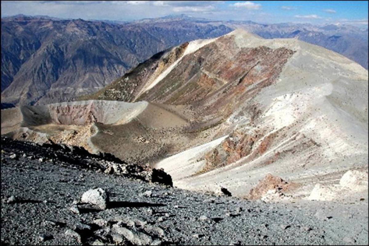
Approaching Huaynaputina, hikers are met with a vast volcanic crater rather than a classic mountain peak. The landscape is stark and powerful, shaped by the largest volcanic eruption in South America’s history in 1600. The terrain contrasts barren volcanic ash and rock with the surrounding Andean highlands. Trekking here offers a profound connection to Earth’s geological forces and a rare chance to stand within a massive volcanic amphitheater. Reaching the crater rim, the silence and sweeping views evoke the immense energy once unleashed here, making the experience both humbling and exhilarating.

Geological Background of Huaynaputina Volcano
Huaynaputina is a stratovolcano located in the Central Volcanic Zone of the Andes, formed by the subduction of the Nazca Plate beneath the South American Plate. Unlike typical cone-shaped volcanoes, Huaynaputina features a large volcanic crater with an amphitheater-shaped structure, possibly a former caldera or shaped by glacial erosion. Its eruptions have produced dacitic magma rich in volcanic minerals. The most notable eruption occurred on February 19, 1600, a VEI 6 event that expelled approximately 30 cubic kilometers of tephra. This eruption devastated the surrounding region, burying villages under meters of volcanic material and triggering lahars that reached the Pacific coast 120 kilometers away. The eruption’s climatic impact was global, inducing a volcanic winter that contributed to famines and social upheavals worldwide. Since then, Huaynaputina has remained dormant, though fumaroles and hot springs indicate residual geothermal activity.
Terrain and Hiking Experience on Huaynaputina
Trekking Huaynaputina is a unique adventure that immerses hikers in a dramatic volcanic landscape shaped by one of history’s most powerful eruptions. The trail leads through rugged volcanic terrain characterized by loose ash deposits, rocky slopes, and scattered volcanic debris. Hikers should be prepared for moderate elevation gain, typically around 400 meters, with the summit reaching approximately 4,850 meters above sea level. The ascent involves navigating uneven volcanic rock and ash, which can be slippery and unstable, requiring careful footing and good hiking boots with solid grip. The terrain is largely barren, with sparse vegetation due to the volcanic soil and high altitude, but the starkness enhances the sense of isolation and raw natural power. Weather conditions can vary, with cool temperatures and strong winds common near the crater rim. Altitude effects may be felt, so acclimatization in the region is advisable before attempting the hike. The trail offers panoramic views of the surrounding Andes and the vast volcanic crater, providing a rewarding experience for those prepared for the physical and environmental challenges. The volcanic ash and pumice fields require steady pacing, and hikers should be ready for sudden weather changes, including cold winds and occasional rain, especially outside the dry season. Overall, the Huaynaputina trek combines geological intrigue with physical challenge, making it a compelling destination for volcano enthusiasts and experienced hikers alike.
What Makes the Huaynaputina Trek Unique
Huaynaputina stands out for its historical significance as the site of South America’s largest recorded volcanic eruption in 1600. Unlike many volcanoes with prominent peaks, Huaynaputina’s defining feature is its vast crater and amphitheater-shaped structure, offering a rare glimpse into a massive volcanic caldera. The trek provides an extraordinary opportunity to explore a landscape shaped by catastrophic volcanic forces, with extensive ash deposits and pyroclastic flow remnants visible along the route. The global climatic impact of its eruption adds a profound historical dimension, linking this remote volcano to worldwide environmental and social changes. The presence of fumaroles and hot springs nearby hints at ongoing geothermal activity, enhancing the scientific interest. The surrounding Moquegua region offers additional volcanic and cultural attractions, making Huaynaputina a unique blend of natural power, geological history, and cultural legacy.
The Summit and Crater Experience on Huaynaputina
Reaching the summit of Huaynaputina places hikers on the rim of a vast volcanic amphitheater, where the scale of the 1600 eruption becomes tangible. The crater is expansive and barren, with fumaroles emitting steam and the faint sulfur scent lingering in the air. The ground beneath is a mosaic of volcanic rock and ash, remnants of pyroclastic flows that once surged through the area. From the rim, panoramic views stretch across the Andes, revealing rugged peaks and distant valleys. The silence at the summit is profound, broken only by the wind and occasional bird calls. The experience is both humbling and awe-inspiring, offering a direct connection to Earth’s volcanic forces and a moment to reflect on the power that reshaped this landscape centuries ago.
Best Time to Trek Huaynaputina Volcano
The optimal time to hike Huaynaputina is during Peru’s dry season, from May to September. During these months, the weather is more stable, with clear skies and minimal rainfall, providing safer and more comfortable trekking conditions. Daytime temperatures typically range from 5°C to 18°C, but can drop significantly near the crater rim, especially in the early morning or late afternoon. The dry season also reduces the risk of slippery volcanic ash and muddy trails. Transitional months like April and October can be unpredictable, with occasional showers, while the wet season from November to March brings frequent rain, higher humidity, and increased trail hazards. Planning your trek during the dry season maximizes visibility, trail safety, and overall enjoyment of the volcanic landscape.
Trekking Routes and Trail Options on Huaynaputina
Huaynaputina’s trekking routes are less formalized compared to more frequented volcanoes, reflecting its remote location and limited tourism infrastructure. The primary approach begins from local communities in the Moquegua region, where hikers can access the volcanic plateau and the crater rim. The main trail involves a moderate ascent of approximately 400 meters in elevation gain, traversing volcanic ash fields and rocky slopes. The route typically takes 2 to 3 hours round trip, depending on fitness and weather conditions. Due to the volcano’s dormancy and rugged terrain, guided tours are recommended for safety and navigation. Local tour operators such as Alpaca Expeditions and XTreme Tourbulencia offer organized hikes that include transportation, permits, and expert guidance. These tours often combine Huaynaputina with other regional geological and cultural sites, providing a comprehensive experience. Self-guided trekking is possible but requires careful preparation, including detailed maps, GPS, and knowledge of local conditions. Alternative routes may explore the surrounding volcanic landscape and hot springs, but these are less established and should only be attempted with local advice. Overall, trekking Huaynaputina offers a moderately challenging route through a dramatic volcanic environment, best experienced with professional support.
Difficulty Assessment of the Huaynaputina Trek
Huaynaputina presents a moderate trekking challenge suitable for hikers with good fitness and some high-altitude experience. The trail involves steady elevation gain to nearly 4,850 meters, where thinner air can affect breathing and endurance. Terrain includes loose volcanic ash, rocky slopes, and uneven surfaces requiring surefootedness and sturdy hiking boots. The absence of shade and exposure to wind and cold temperatures near the crater rim add to the physical demands. While technical climbing is not necessary, hikers should be comfortable with steep ascents and descents on unstable ground. Altitude acclimatization is recommended to mitigate risks of altitude sickness. Overall, the trek is classified as a moderate volcano ascent, accessible to prepared and experienced hikers but not suitable for beginners or those with respiratory or mobility issues.
Essential Gear for Trekking Huaynaputina Volcano
Proper gear is crucial for a safe and comfortable Huaynaputina trek. Recommended items include sturdy hiking boots with excellent grip to handle loose volcanic ash and rocky terrain. Trekking poles can aid balance on uneven slopes. Layered clothing is essential to adapt to temperature fluctuations, including a windproof and waterproof jacket for protection against cold winds and possible rain. Sun protection is vital due to high altitude exposure: bring sunscreen, sunglasses, and a wide-brimmed hat. Carry sufficient water and high-energy snacks to maintain hydration and energy. A headlamp is useful for early starts or late finishes. A basic first aid kit and altitude sickness medication are advisable. Due to fumaroles and sulfur emissions, sensitive individuals may consider a lightweight respirator or mask. Finally, a camera or smartphone is recommended to capture the dramatic volcanic landscapes.
Safety and Volcanic Hazards at Huaynaputina
Although Huaynaputina has been dormant since its massive 1600 eruption, safety precautions remain essential. The volcanic terrain includes unstable ash slopes and loose rocks that can cause slips and falls. The crater rim may have fragile edges, so hikers should maintain a safe distance to avoid accidents. Fumaroles emit volcanic gases such as sulfur dioxide, which can be irritating or harmful; hikers with respiratory conditions should exercise caution. Sudden weather changes, including strong winds and cold temperatures, can increase risk, especially at high altitude. There is no current eruption threat, but the volcano is monitored by the Peruvian Geophysical Institute’s Southern Volcanological Observatory. Visitors should heed local warnings and avoid restricted areas. Guided tours enhance safety by providing expert knowledge and emergency support. Proper acclimatization is important to prevent altitude sickness. Overall, awareness and preparation are key to a safe and rewarding Huaynaputina trekking experience.
Permits, Guides, and Logistics for Huaynaputina Trekking
Trekking Huaynaputina requires obtaining permits from local authorities, as the area is monitored to preserve its geological and cultural significance. Permits can be arranged through authorized tour operators such as Alpaca Expeditions and XTreme Tourbulencia, who provide comprehensive packages including transportation, permits, and experienced guides. These operators facilitate access to the volcanic crater and surrounding trails, ensuring compliance with regulations and enhancing safety. Permit costs vary but generally include park entry fees and guide services. Due to the volcano’s remote location in the Moquegua region, logistics involve travel from Arequipa or Moquegua city, with road access to nearby villages serving as trailheads. Most tours include pickup from these cities and transport to the trail start. Guides offer valuable insights into the volcano’s geology, history, and local culture, enriching the trekking experience. Independent trekking is possible but not recommended without local knowledge and proper permits. Booking in advance is advised, especially during the dry season from May to September, to secure permits and guide availability. Overall, partnering with reputable tour operators ensures a well-organized, safe, and informative trek to Huaynaputina.
Where to Stay and Nearby Bases for Huaynaputina Trekking
Accommodation options near Huaynaputina are limited due to its remote location, but several towns in the Moquegua region provide suitable bases for trekking. The city of Moquegua, approximately 70 kilometers from the volcano, offers a range of hotels and guesthouses with amenities such as restaurants, Wi-Fi, and transportation services. Notable accommodations include Hotel Casa Blanca and Hotel Tacna, which provide comfortable lodging and easy access to local tour operators. Arequipa, a larger city about 150 kilometers away, serves as a major hub with extensive lodging options ranging from budget hostels to luxury hotels like Casa Andina Select and Hotel Libertador. From Arequipa, guided tours typically arrange transport to Huaynaputina’s trailheads. Smaller villages closer to the volcano may offer basic homestays or eco-lodges, but these are sparse and require advance arrangements. Due to the high altitude and rugged terrain, staying in Moquegua or Arequipa allows for proper acclimatization before the trek. Visitors should plan logistics carefully, considering travel times and transport availability. Overall, while direct accommodation near Huaynaputina is minimal, nearby urban centers provide comfortable and convenient bases for exploring this historic volcano.